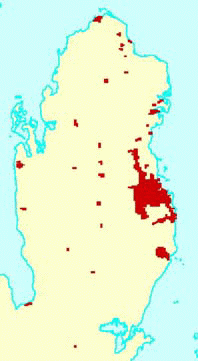
Index of Large scale Orthoimage data set
State of Qatar's National Orthoimage database comprising of 10cm pixel resolution imagery for all urban areas compiled from 1:4,000 scale aerial photography and 1m pixel imagery for the whole country compiled from 1:54,000 scale aerial photography is a major component of the National Topographic database. This paper looks into core aspects of this computer manipulated imagery in true map projection- organization, quality control, accuracy, resampling, replication, cataloging, compression and storage- including its wide usage.
State of Qatar is one of the first country to implement a comprehensive integrated nationwide GIS and is internationally recognized as one of the finest GIS implementations in the world. The Centre for GIS is the principal agency, coordinating systematic implementation of GIS in Qatar. As the official mapping agency for the State of Qatar, the Centre maintains and provides on-line access to National Digital Topographic Database. This comprehensive database comprises of highly accurate, topologically structured Topographic vector maps; high resolution Orthoimagery and high precision Digital Elevation Model(DEM).
This paper looks into Qatar's National Orthoimage database, aspects of this computer manipulated imagery in true map projection- organization, quality control, accuracy, resampling, replication, cataloging, compression and storage- including its wide usage.
Modern Geographical Information Systems(GIS) allow joint processing of vector and raster data. Scanned aerial photos contain a wide spectrum of information that is of interest to GIS, but cannot be directly processed in GIS because of its geometric distortions.
Digital Orthoimagery is comprised of a computer-compatible raster image which has been analytically rectified to eliminate distortions arising from the camera system, the attitude of the camera at the time of exposure, and the image displacement occurring as a function of relief. The resultant image resembles an aerial photograph, but is a computer manipulated image in true map projection form. These geo-referenced images thus constitute a photo map supporting measurement of azimuth, distance and area.
The Large scale data set consists of 10cm resolution original orthoimage compiled from 1:4,000 scale aerial photographs dated 1993 for urban areas and villages. Resampled versions of this original data set to 20cm and 50cm are also available in the database.
Index of Large scale Orthoimage data set
The Small scale data set consists of 100cm resolution orthoimages compiled from 1:54,000 scale aerial photographs dated 1995, covering the entire country. Resampled versions of this original image to 200cm and 500cm resolution images are also available in the database.
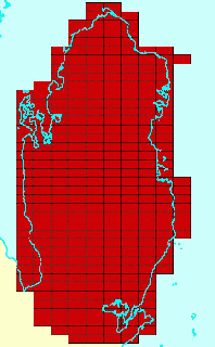
Index of Small scale Orthoimage data set
Because of its high resolution, the amount of detail it contains, and the fact it is on-line to all users, Orthoimagery has found a wide variety of applications in Qatar including: strategic planning; layout and design; inventory management and display; and as a backdrop for overlaying underground services and other thematic data.
Resolution : 10cm
RMS error : Less than 3 pixels
Image format : TIFF 5.0
Spatial tile : 1000 meter X 500 meter
Scanning resolution : 25 microns
Size of original image 10cm : 50 MB
Size of resampled image 20cm : 12.5 MB
Size of resampled image 50cm : 2 MB
Year of photography : 1993
Resolution : 100cm
RMS error : Less than 3 pixels
Image format : TIFF 5.0
Spatial tile : 10,000 meter X 5,000 meter
Scanning resolution : 25 microns
Size of original image 100cm : 50 MB
Size of resampled image 200cm: 12.5 MB
Size of resampled image 500cm: 2 MB
Year of photography : 1995
Digital orthophotos are created in a five step process.
The coverage area is planned, aerial photography is taken during conditions favorable for producing clear photos at a scale appropriate for the accuracy and resolution required.
Sufficient horizontal and vertical control points are provided to orient the photographs to known coordinate system. Analytical aerial triangulation is performed to mathematically densify the ground control.
Aerail photos are scanned, at high resolutions producing continuos tone, digital raster images of the photography. The scanner should have high degree of geometric and radiometric accuracy.
Aerial photographs are used to compile a digital Elevation model of the area, a series of x,y,z coordinates that accurately depicts the surface of the earth. The DEM must be accurate and dense enough to adequately define the surface. Two types of DEM features are compiled, the mass points defines a grid-type pattern of height points, and breaklines defines the change in shape of the ground. Mass points need to be collected in a denser configuration if the variations in the terrain are more.
The final tiled images are delivered to the Centre in CD ROM. For easy handling, the 50 MB high resolution images are split into 8 sub tiff images. The page-to-world transformation parameter file also accompanies these tiff files.
The Centre conducts rigorous quality control on these delivered Orthoimages both through software programs and visual check. The quality control procedure consists of two stages:
1. The Initial Quality Control (IQC) involving Image delivery validation, Image parameter verification, Radiometric distribution checking.
2. Final Quality Control(FQC) involving Mosaic line verification, Positional accuracy checking, and Edge checking.
The entire procedure of IQC is automated by an in-house software DOIPrepro.
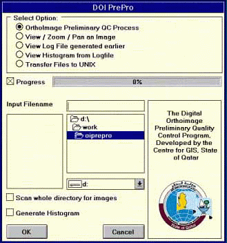
IQC Software -DOIPrepro
Image Width : 2500
Image Length : 2500
Rows Per Strip: 4
No. of Strips: 625
Strip Size : 10000
Image to world transformation parameter no: 1,2,3,4,5 and 6.
Frequency of pixel value distribution are checked and mapped in image Histogram. The software checks the following 'range dispersion' and 'measures of central tendency' pixel values. These values are validated using visual check.
Lower boundary pixel value & Frequency at lower boundary
Upper boundary pixel value & Frequency at upper boundary
Mean Class & Mean Frequency
Standard Deviation
Median Class & Median Frequency
Mode Class & Mode Frequency
The Seam lines are lines along which rectified photos are mosaiced to form the imaged area. Seam lines need to follow surface profile/ground features for distortion free image. The images are checked in ArcView to ensure that no mosaic lines passed through tall features. Seamlines shall also be designed to minimize effects of differing radiometric characteristics between adjacent images.
The edges of the sheet tiles are compared with the adjacent tiles for continuity in pixel position and radiometric balance.
The process of reducing the image data set size by representing a group of pixels with a single pixel. Resampled images are 'coarse' and have less information than the images from which they are taken.
In order to have better storage management and for accommodating wider user base, the original images are resampled into medium and low images. Original 10cm (50 MB) image is resampled to medium 20cm (12.5 MB) and low 50cm (2 MB)images. Also original 100cm (50 MB) image is resampled to medium 200cm (12.5 MB) and low 500cm (2 MB)images.
Storage management involves finalizing the storage pattern in different platforms taking into consideration the following aspects - size of the data set, frequency of usage, wider availability of the images to the users.
The Centre maintains 20cm, 50cm, 100cm, 200cm, 500cm, data sets in NT platform on-line. Due to the large space requirement, 10cm resolution image is kept off-line and is available on demand.
In Unix platform, 50 cm, 200 cm, and 500 cm data sets are maintained on-line.
The Unix data sets are generated through a system replication process from the NT platform and hence called replicated data set.
An organized set of spatially referenced, possibly overlapping, images that can be accessed as one logical image. An image catalog is a group of images on disk, each referenced by a record in an INFO data file. At a minimum, items in the data file include the image pathname and the bounding coordinates xmin,ymin and xmax,ymax.
The Centre maintains respective image catalogs in both NT and Unix platforms for Arc/info and ArcView applications.
The Current data set is made from photography taken in 1993 and 1995. A new Orthoimage update is planned.
Qatar's National Orthoimage database is one of the most comprehensive and accurate spatial data resource for the GIS community. Highlight of this huge data set is that the entire country is orthomapped with highly accurate Urban data.
Co-author:
Name : Krishna Kumar R Nair
Title : GIS Analyst
Organization : The Centre for Geographic Information Systems
Address : P B. No. 22088, Doha, Qatar
Telephone : +974-337549
Fax number : +974-444036
E-mail address : nkrishna@gisqatar.org.qa