In an effort to stop the shooting of raptors, the Hawk Mountain
Sanctuary was established in 1934 as the world's first refuge for these
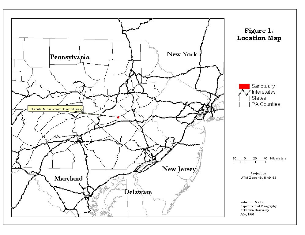
birds of prey. The Sanctuary is a 2,400-acre natural area straddling the
Kittatinny Ridge, the eastern-most crest of the Appalachian Mountains within
Pennsylvania, see Figure 1. Its mission is to foster the conservation of
birds of prey worldwide and to create a better understanding of the natural
environment. During the last 65 years, the Sanctuary has become an international
center for conservation, education, and research about raptors.
The more than 70,000 annual visitors to Hawk Mountain have scenic vistas of the Appalachian Ridge and Valley Provinces from the Sanctuary's lookouts as well as opportunities to observe the birds of prey migrations. A combination of mountain topography and prevailing northwesterly winds places Hawk Mountain along a major migration route for Western Hemisphere birds. From late summer through fall, an average of 18,000 hawks, eagles, and falcons representing 16 of North America's 34 species of raptors and vultures fly past North Lookout, a rocky promontory 1,521 feet in elevation. Ospreys, American Kestrels, and thousands of Broad-winged Hawks move though in late August and September, while October brings a greater variety of species including Sharp-shinned and Cooper's Hawks, Peregrine Falcons, and Merlins. November and early December bring Red-tailed Hawks, Golden Eagles, Goshawks, and even the occasional Rough-legged Hawk.
The science-based conservation research programs at Hawk Mountain have focused on long-term environmental monitoring, applied research, local land-use planning and public education.
"The Sanctuary's scientific effort is based on the belief that fundamental ecological research and long-term monitoring provide an essential foundation for understanding and managing our natural resources." (HMS Research Report, 1995)To improve the management of this unique refuge, Hawk Mountain Sanctuary and the Department of Geography, Kutztown University entered into a two year Memorandum of Understanding in 1996 to develop a Biological Inventory Geographic Information System, HMS/GIS. This agreement was subsequently extended for an additional year until June 1999. This effort has been funded by grants from the Pennsylvania Department of Natural Resources and Conservation, the McLean Contributionship, the National Park Service National Landmark Program, and the Hawk Mountain Sanctuary Association.
Over the last three years the process of developing the HMS/GIS has
had to overcome a number of problems. A discussion of some those problems
is the focus of this paper.
Based on our discussion the specific themes to be developed for the biological inventory were the following.
Transportation Features
Roads (paved, unpaved, logging), Railroads, Foot trails
Hydrologic Features
Streams, Ponds, Springs, Wetlands, Flood plains
Physiographic Features
Elevation, Slope, Aspect, Geology, and Soils
Infrastructure (other than Transportation)
Boundaries, Buildings, Lookouts, Amphitheater, Statues, Shelters, etc.
Property Ownership
Tax parcel and Land-use information
Flora Features
Woodlands, Open and Logged areas, Mushrooms, Aquatic and Unique Vegetation
Fauna Features
Avian species (breeding, wintering and migrant use patterns), Mammals, Reptiles, Amphibians, Fish, and Insects (butterflies, moths, and aquatic).
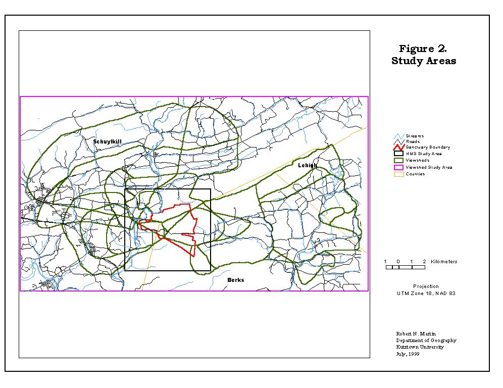
The overall project would have two study areas that differed in
scale. The Hawk Mountain Sanctuary study area would focus on the Sanctuary
itself and the area within a one- kilometer buffer, see Figure 2. The Sanctuary
study area would be the most detailed in terms of coverages. The second
study area would be based on the viewsheds of Hawk Mountain Sanctuary based
on observation from the various lookouts. While the number and type of
coverages for the viewshed study area would be smaller, it was with this
study area that we had the most problems in developing the HMS/GIS.
In consultation with the Hawk Mountain staff, it was decided that the
biological inventory GIS would be developed for use with ArcView GIS. This
software would provide a relatively easy-to-use platform for most of the
staff and had the analytical tools needed for planning and research. And
it was agreed that all coverages would be projected into a Universal Transverse
Mercator projection for Zone 18 based on North America Datum 1983.
The Hawk Mountain staff and volunteers as well as Kutztown University
Geography research assistants and/or interns collected the themes (coverages).
The information for the themes was based on field surveys and research,
Hawk Mountain research archive sources, and public data sources. Data collection
and entry into a GIS format for most of the themes produced very few problems.
However, this was not the case for four basic themes. In particular, the
Boundaries, Parcels, Soils, and Elevation themes had problems that slowed
the development and implementation of the final HMS/GIS.
The major problems faced in developing the HMS/GIS were primarily related to the Sanctuary's location in two counties and on four USGS topographic map sheets. In other words, we faced the typical GIS problem that the study areas did not fit onto one map. County files were the sources for boundary, parcels and soils information while the topographic maps were the basis for developing elevation, slope and aspect models for the study area. In addition, the viewshed study area required that a part of a third county be included in order to have complete coverage. The problems dealing with the boundary and parcel files will be discussed first since these were the most difficult to resolve. This will be followed by a discussion of the problems related to the topographic maps and finally the soil maps problem will be considered.
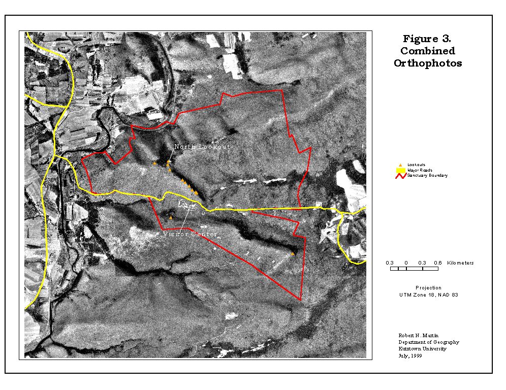
The boundary of Hawk Mountain Sanctuary was built by using a series of plans from a 1984 survey. These plans were at a scale of 1:2400 and highly detailed. However, they lacked any geographic coordinates and therefore coordinate geometry, COGO, was used to build the initial boundary file. To geo-reference this boundary file the Sanctuary had a series of blueprint copies of orthophotos developed for the State of Pennsylvania to inventory state forests and game lands that surround most of the Sanctuary. These orthophotos were scaled at 1:4800 and 1:2400 and had been overlaid with a State Plane, PA-South, NAD 1927 grid. The major features on these orthophotos were manually digitized and became the basis of geo-registering the survey boundary file. After geo-referencing the survey file it was immediately apparent that something was wrong. The boundary of the Sanctuary built from the surveyor's plans did not match the boundary digitized from the orthophotos. Even taking into account the fact that the blue prints may have warped over time, the errors in the shape of the Sanctuary's boundary could not be resolved.
The purchase of a GPS, Trimble Pathfinder ProXL, by Hawk Mountain sanctuary allowed the resolution of boundary shape and registration problems. The GPS was used to geo-register the boundary of the Sanctuary as well as all trails, buildings, streams, and many other small features. When compared to the Pennsylvania forestry orthophotos and USGS digital orthophoto quarter quads, DOQQ, which were acquired later, we found that the average error for the features was about plus/minus one to two meters, see Figure 3. However, I would caution that this minimal error was only for features that could be seen on the orthophotos and not for the manmade line features such as political or property boundaries that had been added to the orthophotos.
The three counties within the viewshed study area, Berks, Lehigh, and Schuylkill, had their own unique method for recording their tax parcels. The files for Berks County, on the southern side of Kittatinny Ridge, were available in an Arc/Info export format for each township and borough. The tax parcel plat sheets had been digitized and edge-matched by the county's tax office and were in State Plane, PA-South, NAD 1927 coordinates. For the two townships within the study area, Windsor and Albany, the files were purchased from the county and imported into a coverage for the study area. There was some minor editing that had to be done for these two townships before they were projected in UTM Zone 18, NAD 1983 coordinates.
For Schuylkill County, on the northern side of Kittatinny Ridge, we had to purchase paper copies of the twenty-nine plat sheets that covered East and West Brunswick townships. Each sheet had a grid of the State Plane, PA-South, NAD 1927 coordinates, which became our georeferencing registration tics for the digitizing process. This resulted in the usual time-consuming digitizing process with added complications. Specifically, the neighboring plat sheets included parcels that did not match up because one sheet had been updated but not its neighbor. In addition, there were several cases where a subdivision had been added in the margins of a plat sheet but its scale differed from the rest of the sheet or that it was supposed to be located on a different plat sheet entirely. The problem of the same parcel having different shapes on bordering plat sheets was resolved by assuming that the 'smaller' parcels were correct. This assumption was based on the fact that the region is undergoing rapid development, especially housing development and therefore there would be subdividing of property and not merging. As for the subdivision inserts, these were digitized as separate files and then using an affine transformation they were registered to their correct location.
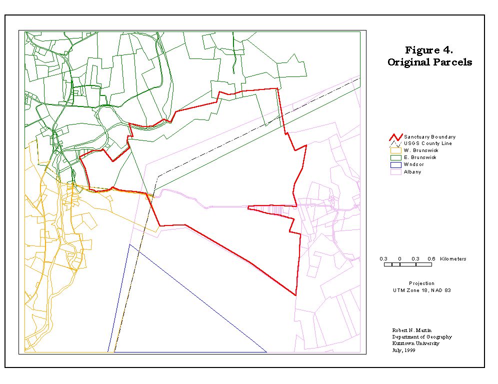
When the digital parcels files for Berks and Schuylkill counties were
merged, a new problem arose. Specifically, there was a significant overlap
in their boundaries
resulting in both counties claiming the same land, see Figure 4. The
largest difference in this overlap is a distance of approximately 500 meters.
It should also be noted in Figure 4 that county line from the USGS topographic
maps does not match the boundary claimed by either county, yet that
the road network does have very close match. One possible explanation
for these anomalies is that Hawk Mountain Sanctuary is surrounded by state
game or forest lands. Since these lands are not taxable, the counties are
not concerned by where their common boundary falls on parcel plat sheets.
This explanation is supported by the fact that as you move away from the
state owned land, the difference in county boundary location decreases.
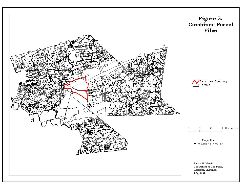
Lehigh County to the east was the worst case scenario in terms of the property parcels files. We obtained fourteen digital files from the Lehigh County Agricultural Land Preservation Board that covered Lynn Township, the area within the viewshed. These files were in an AutoCAD .DXF format. Each file represented a single plat sheet. While each file included a set of grid lines, the coordinate system was 'paper space' and the grid lines had no annotation as to their value. These files had one of the same problems that we found in Schuylkill County, i.e.; property parcels had been edited on a single plat sheet basis. In addition, we found that the scale of each sheet was not constant. Luckily there was sufficient overlap in the digital plat sheets to allow co-registration of the sheets with an affine transformation. Once all the sheets were co-registered into a single coverage based on paper space coordinates, the Lynn Township coverage was projected into a UTM Zone 18, NAD 1983 coordinate system registered to parcel coverage for the other two counties with an affine transformation. At this point some minor editing was necessary along the overlapping areas, see Figure 5.
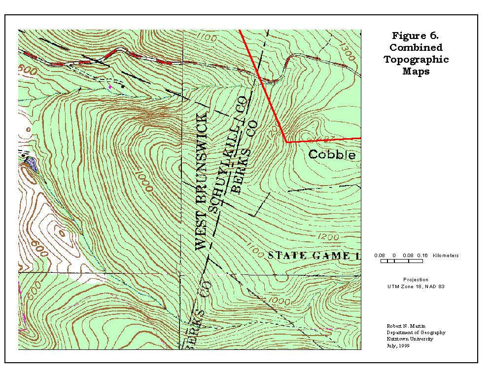
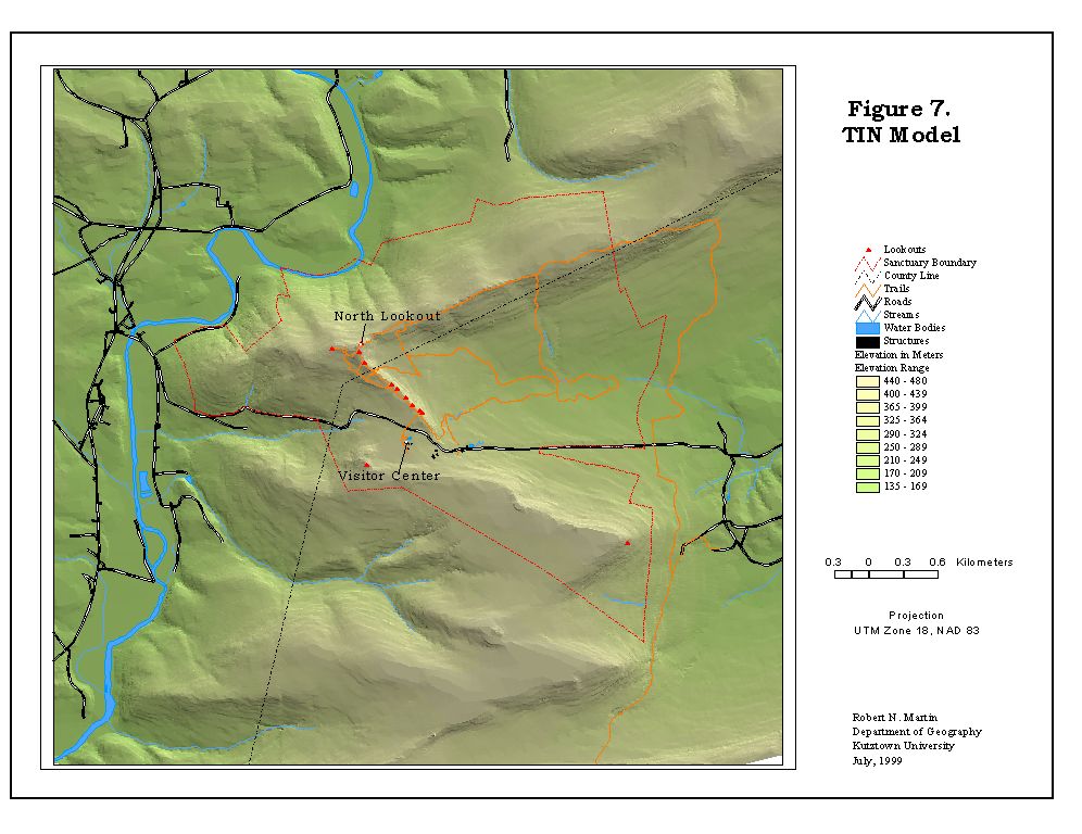
Besides the problems with the parcel files from county sources, we also had a problem related to the USGS topographic maps for the study areas. Initially, we had obtained the 30-meter digital elevation model, DEM, files from the United States Geological Survey for the four topographic maps that covered the study area. When these grid files were merged and a shaded relief model developed, there was a distinctive 'plus' sign at the junction of map sheets. Upon closer examination, it was noted that by crossing the topographic sheet edge elevation grid cells values could change as much as 20 meters. Various smoothing operations did not seem appropriate and they did not remove the problem. Therefore the 20-foot contour lines on the Hawk Mountain study area portions of the Orwigsburg, Auburn, Hamburg, and New Ringgold USGS 7.5-minute topographic maps sheets were manually digitized. These files were merged into a single contour map but the 'plus' problem remained however at a smaller elevation difference. The final solution to this problem was the use of the USGS digital raster graphics, DRG, for the topographic maps. These were merged and the source of the error became apparent, see Figure 6. Along the junction of the four map sheets there are differences in the location of the same contour line. By averaging the difference in location while maintaining the shape as much as possible, the manually digitized contour lines were edited. From these edited contour lines a triangulated irregular network, TIN, was developed with streams and water features as breaklines, see Figure 7. This TIN became the basic elevation model for the Hawk Mountain study and the basis for the slope and aspect themes.
Before closing this section let me mention that problems with the soil
maps still have to been resolved. In particular, the problem is that at
the political boundary of the Berks and Schuylkill counties the
soils change. The classification of soil type and the shape of the soil
polygons are different across the county line. The present development
of new GIS based soil maps for the State of Pennsylvania will hopefully
solve this problem in the very near future.
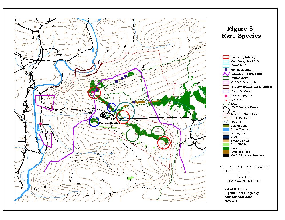
The biological inventory unveiled numerous interesting discoveries including the addition of two new mammals to the Sanctuary's inventory: Pine Vole (Pitymys pinetorum) and Pygmy Shrew (Microsorex hoyi). The first inventories for butterflies, moths, and mushrooms were compiled. The migration paths of the spotted salamanders (Ambystoma maculatum) during mating season were identified and mapped, see Figure 8.
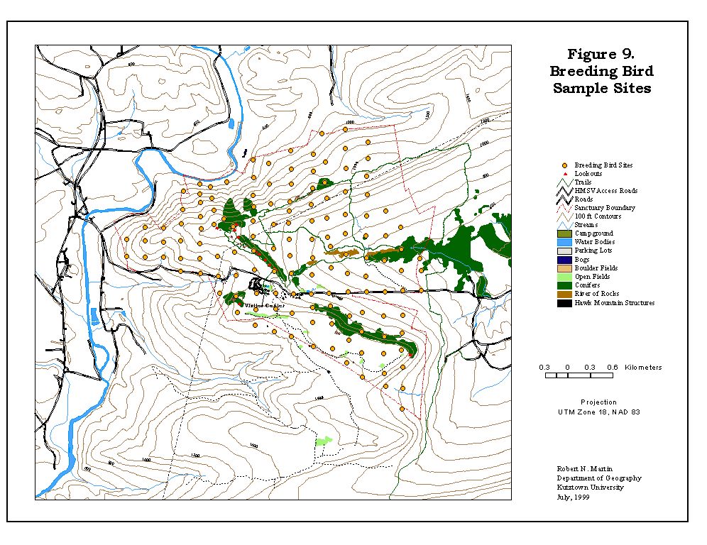
HMS/GIS allowed the determination of a sampling grid for the breeding birds surveys to preclude double counting, see Figure 9. The distribution of the number and type of breeding birds observed or heard could be mapped as well as their potential spatial distribution estimated. The spatial distribution of the breeding birds could, in part, be related to vegetation type, the amount of clearing, elevation and/or aspect.
While the problems with the parcel files and topographic maps were frustrating, they did provide an excellent learning experience for my students and myself. It was also a learning experience for the Hawk Mountain Sanctuary personnel involved with project - they learned not to trust maps but to approach them with an open and questioning mind.
This GIS project has been one of challenges and rewards for the last
three years. Having completed almost all of the biological inventory, the
Hawk Mountain Sanctuary staff and the Department of Geography are committed
to maintaining and expanding the database to meet the Sanctuary's needs
for management and planning. To date the Hawk Mountain biological inventory
GIS has been a success. It has help explain the location of breeding bird-nesting
sites; map salamander migration routes; and provide a better understanding
of the complex environment that is Hawk Mountain Sanctuary.
Mark Monroe, "Spring Rains Bring Herpetological Activity to Hawk Mountain," Kempton, PA: Hawk Mountain Sanctuary Association, 1998.
Mark Monroe, "Hawk Mountain Sanctuary Biological Inventory," Kempton, PA: Hawk Mountain Sanctuary Association, 1998.
Mark Monroe and Laurie Goodrich, "Breeding Birds of Hawk Mountain Sanctuary," Kempton, PA: Hawk Mountain Sanctuary Association, May 1999.