1 Abstract
EnviCat can used for documentation of geodata with FGDC/ISO metadata in a distributed environment. Input of metadata is done in batch mode or with JAVA forms. An ActiveX-based GUI similar to Windows Explorer is developed for integrated WWW-based browse/query and visualisation of metadata and geodata. Data can be ordered and downloaded online. Before download, automatic processing can be ordered (clipping, feature extraction, format- and projection-conversion). The system can handle multiple user groups with complex access rules. All data can also be directly visualized with ArcView IMS.
Key components are SDE, Oracle, Oracle Web Application Server, ArcView IMS, ISO metadata, VB, ActiveX and FME.
Among the users are Swedish Space Corporation, Swedish National Land Survey, the Swedish EPA and the Swedish Road Agency.
2 System overview
EnviCat is a system used for:
It is a general system that utilises the Internet, where different user categories can work in parallel. With EnviCat as a platform, MDC offers services in the above fields.
Figure 1. GeoData Explorer is the user-client for accessing data in EnviCat
EnviCat was initially designed to meet MDC’s requirements for handling geographic data. The system is centred on a meta-database that stores all information on geographic data, maps, user groups, authorisation, etc. This strategy has been important, as the meta-database is one of the main components for data administration. During the development phase, great interest has been shown in the system and MDC also offers other services based on EnviCat.
2.1 Meta data
The core of the system is a meta-database developed in line with the meta data standard of the FGDC (Federal Geographic Data Committee) in the USA. Certain parts of the draft of the international standardisation project (ISO) and the Cataloguing Services within the OGC have also been incorporated in the system. It has been implemented with approx. 60 tables in an ORACLE 8 relational database.
The aim is that when the ISO-standard is ready, EnviCat will use its structure. It is our hope that Sweden too will make a decision to choose the ISO option regarding meta data. Future development among software suppliers within the OGC (Open GIS Consortium) does not deal with meta data itself, but instead refers to ISO work.
In order to register meta data, a complete JAVA-based form input has been developed. This means being able to use e.g. Netscape to edit the approx. 25 forms the input application consists of. The main groups of information that the user can register information about are:
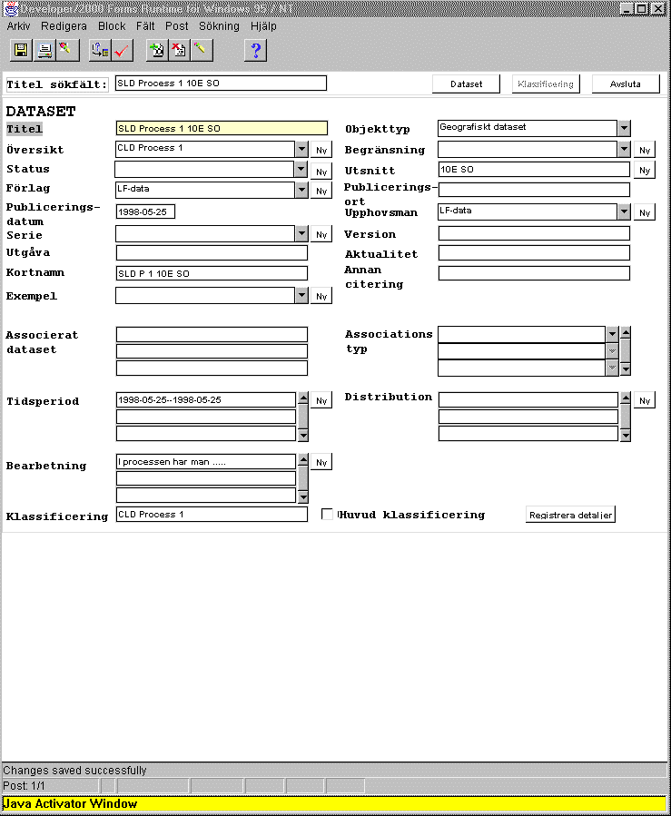
Figure 2. Design of main form for registering meta data via the Internet
The meta-database is used jointly for several different users. This is solved by different user groups being given authorisation to different sections of the database.
2.2 Geographic data
Storage of geographic data sets is done in the same ORACLE 8 database as for the meta data. The Spatial Database Engine (SDE) from Esri is used for this. This close link between data and meta data facilitates data administration. The goal is that no data shall be able to be stored unless certain meta data is registered. However, some data sets are stored as files to be downloadable over the Internet without preceding conversion or processing of e.g. different types of raster data.
2.3 System overview
The system is basically built on ORACLE 8.0, which handles the geographic data and meta data, stores map presentations, user groups and session logs. There are server functions around this database that manage different types of query.
2.4 GeoData Explorer
The functions built up on the server for searching, browsing meta data and processing and retrieving data can be accessed via a self-developed programme called GeoData Explorer (GDE). The intention has been for it to resemble the ordinary Explorer in Windows NT or 95 both visually and practically.
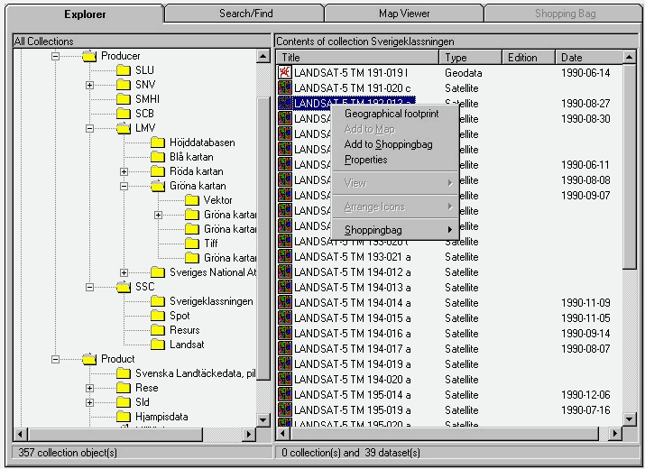
Figure 3. GeoData Explorer is the user interface the user meets when working with EnviCat. In it, the user can browse and search for data, look at interactive map presentations, download data and order data-processing prior to downloading.
GDE consists of four main tabs.
EnviCat has been developed as a system for frequent users rather than for the one-off user. Once the programme has been installed, subsequent start-ups will be rapid.
Therefore GDE is built like an ActiveX component, which means that it has a Windows-like interface. When the user wishes to work with EnviCat for the first time, the GDE is downloaded over the Internet and installed on the user’s computer. At the following start-up it retrieves the programme which is now installed. Certain functions used in the programme have often already been downloaded in Windows NT/95 on the machine it is run on.
It will also be possible to browse through the data catalogue without needing to wait for a reply from a WWW server for each link clicked on. Therefore a local meta catalogue is installed with a very limited selection of meta data on the local computer. This local meta catalogue is automatically updated to be continually synchronised with the central meta-database.
2.4.1 Explorer
Below the first tab -"Explorer" – you can see the meta data catalogue divided into collections (classifications) in a tree structure in the left frame and the data set itself in the right frame. In the Windows Explorer the classifications of libraries and geographic data sets correspond to data files.
This structure is used to organise data into a logical hierarchy suited to the user’s needs. For example, data can be organised into a producer-oriented structure in which all the producers are indicated on the highest level. Below that the products of each producer are shown. Below the product level any versions of the product are shown. This producer-oriented classification is suitable for those who know what kind of products the different producers offer. For those more thematically-oriented, a parallel, thematic classification can be offered where for example all road data sets, irrespective of their database, are classified in the same thematic group. This type of thematic or activity-based classification is suitable for organising meta data for a special group of people, for example for physical planning, a municipal public works office or the environmental office of a regional administration authority. Each group will then often have its own classification system.
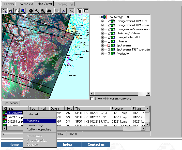
When a data set of interest has been found, it can be studied in more detail by requesting meta data about the data set, looking at a sample image or drawing the geographic section for the data set on the map.
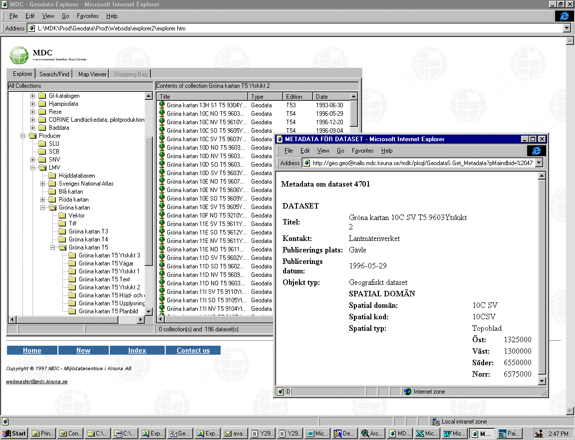
Figure 4. If you request meta data about the data set a meta data report is generated. These come in three different variants with an overview showing the basic identification information with storage information oriented towards describing how the data is stored, plus a third variant which shows a complete abstract can of the meta-database.

Figure 5. If you choose the alternative of showing the geographic extent, then rectangles appear on the map showing the geographic scope of the data set.
When an interesting data set has been identified, it can be ordered by placing it in the "shopping bag". If the user is not interested in receiving the whole data set or if the data was originally stored in the wrong format, then the user can request "Extract data" to a customer-oriented product and thereafter place it in the shopping bag for downloading.
Upon choosing Extract Data, a form appears with three tabs: Selection, Projection, and Format.
2.4.1.1 Selection
This alternative allows the user to make a selection based on geographic criteria or properties stored in the data set. These properties may be e.g. road codes, vegetation classes, category codes.
2.4.1.1.1 Geographic selection
Geographic selection can be made by first choosing a type of section, e.g. administrative district or topo sheet. After that the user can select one or more sections from this list, e.g. three council districts, from which to cut data. Another alternative for making the selection is to freely define a polygon in a map for data sectioning
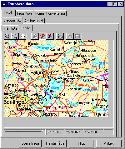
Figure 6. In the selection form you can make both a geographic selection and one based on the properties of the data set.
2.4.1.1.2 Attribute selection
Here the user has the possibility to choose one or more fields in the data set from which to make a selection, subsequently determining the operator, and the values from a list. The user may for example have chosen to extract data from the blue map, while only wishing to retrieve the main roads. The user then chooses to make the selection in the field for category codes, selecting the codes that include main roads.
2.4.1.2 Projecting
If a special projection is desired the user can choose from the list of projections which projection the data is to be delivered in. In the first version a number of versions of RT90 will be supported.
2.4.1.3 Format conversion
This tab allows the user to specify which format the data is to be delivered in. The formats supported at present are Esri-shape, DXF and KF85. This selection of output formats will be increased as needed.
2.4.2 Search
If the user’s browsing in Explorer is unsuccessful, there is a tab with search functions incorporating search filters
The search result is shown in a list below the search window
The same menu alternatives are available as for the data set in Explorer.
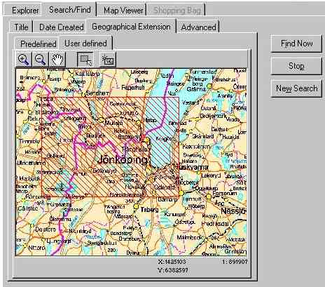
Figure 7. Below the Search tab you may set different search criteria if you cannot find the data set you are interested in.
2.4.3 Map window
Below this tab there is a map display which handles maps generated by the map server. Besides the map window with its standard buttons there is a separate table of symbols and lists below the map to display the search result of searches in any of the geographic data sets
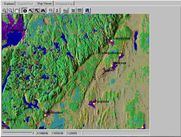
Figure 8. To simplify generation of thematic maps has several background maps benn created that are backdrops for more thematic datasets. The table of symbols and lists of search results may be removed to make room for a larger map format.
The map-generating functions on the server page have been expanded to enable the server to handle an unlimited number of maps. It is not limited to serving one (1) map to many users. The information about the contents of a map and the template the themes included are stored in the meta-database together with the geographic data. The maps are generated upon request and stored in the memory if the requests alternate between completely different map types. Suitable theme titles are also retrieved from the meta-database, as are fields in the database from which data is presented, in order that incomprehensible field names are never shown to the user.
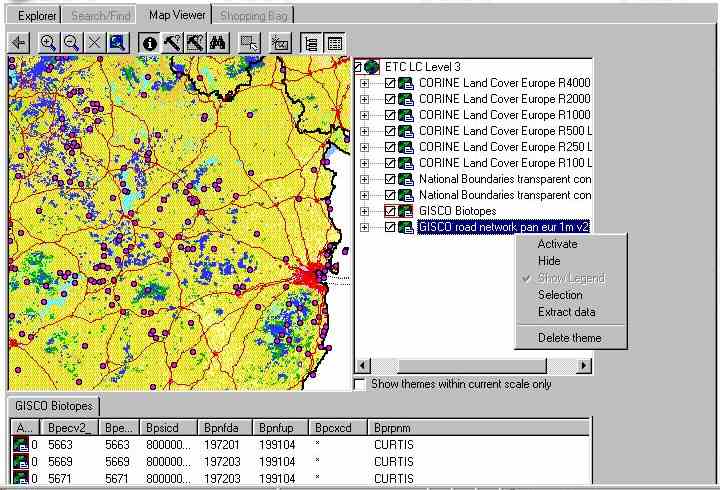
Figure 9. The Map server tab contains a number of standard functions for moving around the map and for asking questions on the themes the map is built up of. Examples are feature-streaming of point and polygon-data to client-software, direct link between queryresult and mapwindow, databasedriven hyperlinks.
2.4.4 Legend
The table of symbols is so built up to enable turning themes on and off and activating/deactivating themes in the traditional way. Also selectable is whether a theme shall be completely hidden to the user in the table of symbols, e.g. background information. One can also automatically hide themes that are not visible due to the scale range being outside the scale range limits set for the theme. Symbol settings for a theme are stored in the meta-database and retrieved for each theme by a click on the plus sign in front of each theme name.
The theme may also be handled hierarchically in the table of symbols, so that all data sets of one object type, e.g. roads, are stored as one item in the table of symbols, thus enabling making them all to be made visible/invisible with one selection.
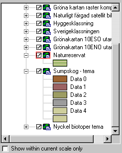
Figure 10. The legend for a map includes several functions to simplify handling of complex maps like grouping and hiding themes.
2.4.5 Shopping bag
When a number of data sets have been placed in the shopping bag and you wish to place an order, click on the shopping bag tab. Under this tab there is a simple list where you may choose to order all or part of the contents. The order can be sent directly to EnviCat or copied to a text file for later faxing or e-mailing. Those possessing an EnviCat account can send the order directly to the server in order to download the data directly. After the order has been sent the data set is packaged on the server with the necessary accompanying files for a shipment, e.g. meta data, template files and reference tables. When the order is packaged and ready for delivery the user is informed and can start to download the data.
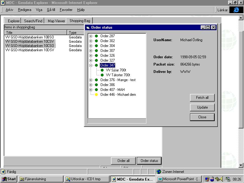
Figure 11. In the shoppingbag can a list of datasets be ordered. Each order can be listed, inspected and tracked before download of data.
3 User categories
A user account is needed to access EnviCat. Certain rights are linked to this account. Some data can be downloaded free of charge: data sets that are not free of charge may only be downloaded if there are allocated funds on the account. Upon downloading data, the cost is deducted from the balance on the user’s account. Functions for direct debiting via an account card etc. are under appraisal but will not be implemented until they have gained general acceptance in Sweden.
4 Present utilisation of EnviCat
Many forms of usage are Intranet applications with restricted group access. The following list is of EnviCat projects currently in progress.
MDC’s own databases
MDC is working on compiling archives of exhaustive satellite data of Sweden from different periods of time. In addition to these satellite imagery products there is also a considerable number of traditional GIS-data sets. They are archived and administered through EnviCat. New products are developed based on these data sets and will be able to be visualised and distributed via EnviCat
Swedish Land Cover Data (formerly Swedish CORINE)
This is a nationwide land cover database that will use satellite data etc. for mapping. EnviCat will be used as a production follow-up system, for documenting the products and for distributing the end product.
RESE (Remote Sensing for the Environment)
This is a research project with a large number of research departments within remote sensing that co-operate to develop environmental applications for satellite data. Input data and available output data will be archived and made accessible in EnviCat.
National Roads Administration
The National Roads Administration uses the system as a data switching exchange to provide geographic data to its regional offices. It is above all external data such as the National Land Survey Agency’s GSD bases and SGU’s products, but also some of its own data such as road information maps and road databases.
The European Environment Agency – EEA
Today the whole European CORINE Land Cover is stored as a distribution-copy in EnviCat. Besides a comprehensive vector base, raster bases in various resolutions are stored. They are available for presentation in the map window or for downloading. On-going discussions are dealing with storing further types of inventory.
SPOT scenes 1997
Satellitbild in Kiruna has produced a practically complete data set of Spot images from summer 1997. EnviCat is used to show the degree of coverage and quick looks at these scenes. It is also possible to place orders for these products.
Swedish National Environmental Protection Agency
A number of co-operation projects for the Swedish National Environmental Protection Agency are going on, in which different types of inventory are to be presented on a standardised map background. The inventories of interest are: wetland inventory, environmental protection inventory, meadow and grazing ground inventory and continual monitoring of the quality of bathing water in lakes. A major issue in this context is the availability of background data, for example from the National Land Survey Agency.
5 Availability
EnviCat is a system-service that is used for distributed work-groups. No open access to the system is available. If you would like to get more information please contact us at
envicat@mdc.kiruna.se or inspect the website www.envicat.com.Michael Östling
Environmental Satellite Data Centre - MDC
Address: Box 806, SE-982 28 Kiruna, Sweden
E-mail:
mos@mdc.kiruna.se Web: www.mdc.kiruna.seTel: +46 980 671 79. Fax: +46 980 671 80
Esri International user Conference, San Diego, July 26-30 1999
Key words: Internet, meta data, data distribution, Internet mapservers, search services