Managing Hawaii’s `Aina: Using GIS for Military Training Land Monitoring and Rehabilitation Prioritization
Nathaniel Whelan
Military land management requires GIS integration for educated training and natural resource decision making, yet the fragile and complex Hawaiian ecosystem poses unique challenges. Natural resource issues, such as severe water and wind erosion, threatened and endangered species, and numerous archaeological sites, conflict with potentially high-impact training activities. Training land condition is determined through land monitoring utilizing a GPS-based field data collection system. ARC/INFO, ArcView GIS, and ArcView Spatial Analyst was utilized to analyze data to evaluate training areas according to land condition and prioritize land rehabilitation and maintenance projects.
INTRODUCTION
The purpose of this report is to present the objectives and findings of Phase I of the Kahuku Training Area erosion study conducted by the Land Condition Trend Analysis (LCTA) program. This study relies on the combination of the Hawaii region Site Rehabilitation Prioritization protocol and the data logging and mapping technology provided by Integrated Training Area Management (ITAM) Global Positioning System. This study intends to identify and prioritize erosion problem areas within the Kahuku Training Area that may conflict with military training exercises. Secondary benefits of this study include a prioritization of erosion areas for ITAM’s Land Rehabilitation and Maintenance (LRAM) program and a strong reference aid for the military land use decision-making process at the installation level.
The LCTA program is one component of the ITAM program and is responsible for inventorying and monitoring the condition of US Army Hawaii training lands. Data provided through the LCTA program will be used during the management and decision making process that integrates Army training and other mission requirements with sustainable natural resource management. A fundamental tool of the LCTA process is the ITAM Geographic Information System (GIS), which acts as a powerful data analysis and map compilation tool. The LCTA program is implemented at a significant number of Army installations and provides a component of a natural resource baseline inventory for these installations.
Previous erosion studies have been conducted within the Kahuku Training Area. Walter Lum Associates (1979) was contracted through US Army Corps of Engineers Pacific Ocean Division to conduct Land Management / Erosion Control Studies throughout Oahu training areas. The Lum report concluded the overall assessment of soil erosion within the Kahuku area appeared more extensive than other US Army Hawaii Oahu installations.
METHODOLOGY
Phase I of this study focuses on mapping and rating eroded, or denuded, areas for rehabilitation prioritization. Field data were collected from October 1998 to February 1999 within areas supporting ground maneuver training and other scheduled training activities, such as bivouac sites, assembly/staging areas, drop zones, and landing zones. Inaccessible naturally eroded areas were not delineated. Following acquisition of digital color infrared orthoimagery (summer, 1999), Phase II of this project will commence and focus on utilizing this remote sensing data to interpret inaccessible gulch eroded areas.
Foot accessible eroded areas were field mapped using a Trimble Pro XR Global Positioning System (GPS). All GPS data was real time differentially corrected using Coast Guard radio beacon transmitting RTCM-104 correction data. Specific criteria used for eroded area selection and boundary delineation are stated below.
Site Rehabilitation Prioritization (SRP) data was collected for each 0.25 acre of mapped eroded area. Each mapped eroded area has a minimum of one SRP sampling point. Data inputs for SRP include slope, slope length, ground cover, canopy percentage, percent polygon degraded, percent polygon active erosion, accessibility, visibility, and potential drainage impacts. SRP data dictionaries were loaded on GPS data loggers for all data collection activities. See document Hawaii Region SRP Monitoring Protocol (Whelan, 1998) for more information.
ENVIRONMENTAL OVERVIEW
Terrain
The Kahuku Training Area encompasses 9,406 acres of leased and federally owned land (as of December 1998). The training area is situated on the slopes at the northern end of the Koolau Mountain Range on the island of Oahu. Elevation varies from roughly 100 ft in the coastal plain to approximately 2,000 ft in the uplands of the Koolau Mountains. The topography of the site consists of uplands and hills dissected by steep walled gullies generally aligned in a northeast to southwest direction. Approximately one-fifth of the Kahuku Training Area consists of gentle lowlands and uplands with 2 – 10% slopes and the remaining area consists of rugged topography and steep gulches with slopes ranging from 25 – 100%.
Land Use History
A review of the land use history is crucial for understanding the vegetative composition and the original causes behind many of the Kahuku Training Area’s erosion concerns. Colonization of the Hawaiian Islands introduced many aggressive alien species that have, in many cases, displaced the native flora and fauna. The alien species domination has forced many native species to exist in inaccessible, high elevation locations.
Sugar cane plantations use to exist along the windward plateau areas within the training area. Vast tracts of lowland native forest were cut to make way for new fields and provide firewood to run the boilers at sugar mills. Agricultural practices, such as vertical plowing, drainage ditches, and fire, promoted erosion particularly on the adjacent sloping gully sidewalls (Cuddihy and Stone, 1990).
Hydrology
The annual rainfall for the site varies from 40 inches to 75 inches near the Koolau crest. The Kahuku Training Area drains into the Kaunala, Waialee, Pahiapahialua, Kawela, Oio, Ohia, Keaaulu, and Mina Gulches, and forms a series of deep cut ephemereal streams that drain northward into the Pacific Ocean. Malaekahana Stream, located at the eastern training area boundary, is a perennial stream. Active United States Geological Service gaging stations are located on Malaekahana Stream, Oio Stream, Kaunala Gulch, and Paumala Gulch.
Vegetation
The Kahuku Training Area has a variety of principal vegetation community types. Areas receiving active training are primarily comprised of lowland mesic grasslands and lowland mesic forests. Aggressive introduced species typically dominate the less diverse lowland areas, including Strawberry Guava (Psidium cattleianum), Christmas Berry (Schinus terebinthifolius), Molasses Grass (Melinis minutiflora), Koa Haole (Leucaena leucocephala), and Bermuda Grass (Cynodon dactylon). The mesic forests extend into the less accessible higher montane elevations, with an associated higher density of native species, such as Koa (Acacia koa) and `Ohi`a (Metrosideros polymorpha).
Soils and Geology
Lowland areas under 800 ft are primarily characterized by two geographically associated soils, the Paumalu - Badland complex and the Kemoo - Badland complex. These are silty clay soils with potential rapid runoff and severe erosion. The upland areas are dominated by Kapaa silty clay. Rock outcrops are typical throughout these areas.
The substratum throughout this area is basic igneous rocks. This is a relatively soft and weathered substrate.
LAND USE
The Kahuku Training Area is subdivided into nine sections: A1, A2, A3, B1, B2, C1, C2, D1, and D2. There are also three drop zones and eleven landing zones for tactical air operations. The Kahuku Training Area is primarily used for tactical maneuver training, mountain and jungle warfare training, and for air support with fixed and rotary winged aircraft. The training area is rugged and mountainous and suitable for light infantry. The size of the training area is adequate for battalion level training and brigade.
This area is leased by the Army from landowners and Campbell Estate (as of December, 1998). In accordance with lease agreements, training restrictions include blanks / limited pyrotechnics allowed, and limited digging. Training occurring on State of Hawaii leased lands allows small arms up to .50 caliber, 3.5 inch rocket or a similar size weapon may be used with inert rounds. No tracer, incendiary ammunition, or live fire is authorized in the Kahuku Training Area. Significant parcels of leased training land were purchased from Campbell Estate in February 1999. This ownership change may impact future training restrictions.
The Kahuku area is also widely used for off-road motor bike recreation. There is an extensive motor bike trail network throughout the training area. Unless training is scheduled at the brigade or larger level, training areas A1and A3, and "A" gate are off limits to training on weekends and federal holidays and are primarily used for motor bike and other recreational activities.
DENUDED AREAS
Erosion problem areas are grouped into five general classifications. The five general classes are (1) denuded areas near the top of gulches, (2) upland plateaus, (3) steep road cuts, (4) eroded roadways, and (5) motor cross trails and recreation areas. The first four classifications correlate to delineations under the Walter Lum Associates Land Management / Erosion Control Study (1979).
The Revised Universal Soil Loss Equation (RUSLE) presents a standardized, scientific method for estimating long term annual soil loss due to water erosion (Renard et al, 1997). The equation calculates average annual soil loss over a field slope. RUSLE is calculated using the following formula:
A = R K LS C P
Where A = Soil loss per unit area (tons/acre/year)
R = Rainfall factor (quantity and intensity of rainfall)
K = Soil erodibility factor
L = Slope length (meters)
S = Slope gradient (percent)
C = Cover factor
P = Erosion control practice factor
Figure 1 displays the estimated average soil loss per unit area (A value) for the denuded area classifications. Steep, bare slopes have significant impacts on the RUSLE calculation.
Figure 1: RUSLE calculated soil loss for vegetated and denuded area classifications. Erosion tolerance is a recommended erosion rate value defining soil loss for water quality concerns. Histogram labeled by estimated soil loss per unit area (tons/acre/year). Scale of X-axis is logarithmic.
Denuded areas near the top of gulches
This category dominates in terms of total area of denudation. Primarily a natural phenomenon, these steep areas are generally inaccessible. Training maneuvers may conflict with these areas along the ridgelines of accessible plateaus. Many of these areas have increased priority because of the high public visibility of these large sites.
These areas are generally windward, or northeast facing. Soils are typically Paumalu – Badland complex or Kemoo – Badland complex, which are subject to severe erosion hazard and rapid runoff. These soils have exposed subsoil and weathered rocks. A generally high acidity and low soil fertility inhibit revegetation projects. Many of these areas are also composed of rockland, where exposed rock covers 25 to 90% of the surface.
Accessible denuded areas near the tops of gulches were selected and field mapped for this study. Areas selected for this phase of field mapping also held potential for active maneuver training.
Upland Plateaus
Plateau areas accessible via the Kahuku road network are typically denuded from natural wind and water erosion. Various active ground maneuver training activities, including individual fighting positions, bivouac sites, landing zones, and drop zones accelerate the erosion process. These areas are also subject to the highest land impact Light Infantry exercises, including vehicular traffic and mechanized excavation.
Upland plateaus typically fall within the Kemoo – Badland complex. Denuded plateau sites typically have minimal vegetative ground cover and 2-12% slopes displaying a slight to moderate erosion hazard. Many upland areas have canopy cover that effectively reduces erosion.
Plateau denuded areas were field mapped and prioritized for this study. Many upland areas adjacent to denuded gully sidewall sites were classified as high priority erosion areas.
Steep road cuts
Steep road cuts are adjacent to many of the east – west roads bisecting the gullies. Roadcuts range in slope from 15% to vertical. Training conflicts from steep road cuts include falling rocks, erosion slumping, and runoff drainage potentially damaging the roadway. Numerous individual fighting positions constructed along road cut ridgelines also promote erosion.
These areas fall within a wide variety of soil complexes. Many roadcuts along the gully sidewalls have similar soil characteristics as denuded areas near tops of gulches. The erosion threat is minimal from road cuts where weathered rock has been exposed
All observed road cuts were field mapped and prioritized using vehicle mounted GPS for this study. GIS buffering analysis based on width and height of road cut was completed following field data collection.
Eroded roadways
Roadways without substrate on sloping ground are subject to severe gully erosion. Gully erosion produces drainage channelization which may hinder or prohibit trafficability. Heavy rainfall causes saturation of the silty clay road surface cover reducing vehicle traction and overall trafficability.
All Kahuku accessible roads were mapped using vehicle mounted GPS and rated based on trafficability. Roads that were impassable during precipitation events and are generally unsafe and impassable under any weather condition were also delineated. All impassable roads were walked for this study.
Motor cross trails and recreation areas
The Waialee Motorcycle Park, located in K-A1, is a popular built-up area for off-road vehicle recreation. A series of courses and motor cross trails originate from this area and network throughout the entire Kahuku parcel. There is high correlation between areas receiving motor cross use, active ground maneuver training, and severe denudation.
The largest parcel primarily impacted from off road vehicle activity is the Motorcycle Park consisting of the Kemoo – Badland soil complex. This silty clay soil complex has a moderate to severe erosion hazard with a medium to rapid runoff. On areas that are denuded, the Badland complex dominates and the erosion hazard is very severe. These areas, such as this recreational park, are also negatively impacted by its windward facing aspect. Furthermore, an ephemereal secondary drainage for Waialee Gulch bisects directly through this site.
Denuded areas overlapping and adjacent to the Waialee Motorcycle Park were mapped and prioritized. The extensive motor cross trail network was not mapped. Trails falling within any type of denuded area were prioritized and photographed.
SITE REHABILITATION PRIORITIZATION
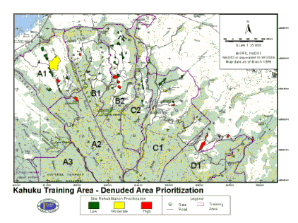
A primary responsibility of the LCTA Hawaii program is to identify and prioritize sites for Land Rehabilitation and Maintenance (LRAM). The SRP protocol provides a qualitative assessment of erosion and aesthetic factors. Erosion removes surface soils, and thereby contributes to water quality degradation, plant nutrient deficiencies, and an overall loss of training areas’ soil resource. SRP calculation is based on percent polygon degraded, slope, percent active erosion, potential impacts, and accessibility. These data are derived from an ocular assessment of the denuded area. Figure 2 displays all mapped denuded sites and their associated ranking themed from green (low priority) to red (high priority).
Figure 2: 15 highest scoring SRP areas that are manageable sized, roughly 1-5 acre sites for LRAM prioritization.
Certain SRP input values are weighted and have a dramatic impact on the final SRP score. These values include slope, percent polygon degraded, and percent polygon experiencing active erosion. These three values are determined to have the greatest impact on erosion rates and are weighted accordingly.
Erosion Susceptibility Analysis
An erosion susceptibility analysis was conducted utilizing ArcView Spatial Analyst. The objective of this analysis was to identify sites that may not be currently denuded but have a high potential for training induced erosion. A series of grid data layers were developed based on the following erosion parameters.
A total of fifteen polygons were outputted from this analysis (figure 3). Many of these areas overlap or are adjacent to current high priority denuded sites. The total number of potential erosion sites will likely be reduced from 15 to 8-10 following field evaluation.
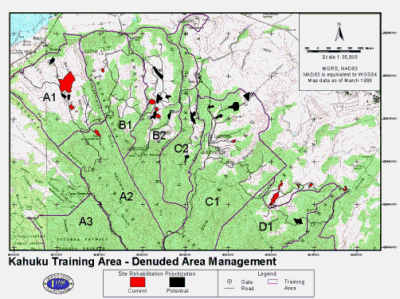
Figure 3: 15 top priority erosion potential polygons and the 15 highest scoring SRP areas.
CONCLUSION
Erosion problem areas are evident throughout active military training sites in the Kahuku Training Area. The Kahuku Training Area appears to have the most extensive erosion concerns of all USARHAW Oahu installations. This study recommends a proactive land management and land user education program be initiated for three primary erosion areas of concern: tactical trafficability, mechanized excavation events, and recreational motor bike use.
Trafficability
Trafficability conflicts appear to be the greatest training impact caused by erosion within the Kahuku Training Area. Gully erosion is the primary cause of untrafficable primary and secondary training roads. This is caused due to lack of substrate material covering road surface and the associated drainage runoff. Updated road network data mapped during this study should aid in educating tactical vehicle operators who usually rely on older, incorrect topographic road maps.
Mechanized Excavation
Training activities, specifically mechanized excavation, particularly along gully sidewalls or plateau ridgelines appears to have the greatest impact on denuded areas. Long steep denuded slopes have the greatest susceptibility to erosion. Continued coordination with trainers concerning timing and location of mechanized excavation events is critical to avoid high priority denuded sites. Erosion check dams and vegetative buffer strips placed downslope of susceptible sites would increase soil stability and reduce non point sedimentation of the area’s hydrologic features.
Motor Cross
Motor cross activity is evident at the majority of the denuded sites. Motor cross trail proliferation, especially trails bisecting previously denuded gully sidewall areas, promote sediment detachment and transport. Off-road vehicle braking and acceleration along the steep trails have the greatest impact on sediment detachment. A full time on site presence of Range Control personnel within the Kahuku Training Area is recommended to act as a deterrent to illegal recreational usage. Increased signage and tactical gate improvements, and improved lines of communications with off road vehicle operators, such as representatives from the Waialee Motorcycle Park, may also aid future proactive management attempts.
Future Research
Phase II of this study will commence in summer 1999 following delivery of high-resolution digital orthoimagery. The second phase will rely on image interpretation to further delineate large inaccessible, naturally eroding gulch sidewalls. Future research is also required in two other realms for natural resource baseline data: a Kahuku vegetation community map and a floristics survey. This data will provide a solid foundation for future Kahuku land management decisions.
REFERENCES
Cuddihy, L.W. and C.P. Stone. 1990. Alteration of Native Hawaiian Vegetation, Effect of Humans, Their Activities and Introductions. Cooperative National Park Resources Studies Unit, University of Hawaii Manoa.
Nakata Planning Group, LLC. 1998. Range and Training Land Program Development Plan. US Army Engineering and Support Center, Huntville, AL.
NRCS. 1972. Soils Survey of Islands of Kauai, Oahu, Maui, Molokai, and Lanai, State of Hawaii. United States Department of Agriculture.
NRCS. 1998. R Factor Maps. Documentation provided by Larry Sineshiro.
Renard, K.G., Foster, G.R., Weenies, G.A., McCool, D.K., and D.C. Yoder. 1997. Predicting Soil Erosion By Water: A Guide To Conservation Planning With the Revised Universal Soil Loss Equation (RUSLE). Agriculture Handbook Number 703.
Soil and Water Conservation Society. 1995. RUSLE User Guide Version 1.04.
USARAK. 1997-8. Conversations with Alaska ITAM personnel.
USCINCPAC. 1995. Hawaii Military Land Use Master Plan. Commander in Chief , U.S. Pacific Command.
Villalobos, H. 1998-9. RFMSS Detail Utilization Report, USARHAW Oahu Training Areas FY97 and FY98. Schofield Barracks Range Control, Range Division Hawaii.
Wagner, W.L., Herbst, D.R., and S.H. Sohmer. 1990. Manual of the Flowering Plants of Hawai’i. Bishop Museum, Honolulu, HI.
Walter Lum Associates, Inc. 1979. Land Management / Erosion Control Study USASCH Installations, Hawaii, Kahuku Training Area. Walter Lum Associates.
Whelan, N. 1998. Hawaii Region SRP Monitoring Protocol. USARHAW LCTA program.
Nathaniel Whelan
Land Condition Trend Analysis Coordinator, Integrated Training Area Management
Headquarters
25th ID (L) & USARHAW
Schofield Barracks, HI 96857
808-655-8463(V)
itamlcta@schofield-emh1.army.mil