Mark
D. MacKenzie, August 11, 1999
Private Forest Landowners and GIS: An Exercise in Technology Transfer
As management goals for the US National Forest System are becoming more
diverse, appropriate forest management by non-industrial private forest
landowners is becoming even more important. GIS has a great potential in
helping to develop and implement forest management plans. This paper presents
an attempt to develop an interactive, web-based GIS using ArcView and ArcView
IMS software to help individuals answer the question - Do I need a GIS?
INTRODUCTION
As you prepare to read this paper, I ask you to answer the following questions:
-
How much of your State is in forests?
-
What is the distribution of forest land ownership in your State (i.e.,
how much is under Federal or State ownership, private industrial ownership,
or private non-industrial ownership)?
Alabama's Forest Resource
In Alabama, approximately 22 million acres, or roughly 67% of the land
surface, are forested. Alabama contains the third largest commercial forest
in the US. These forests are classified into four major forest types: 1)
Pine (33.8%), 2) Pine-Hardwood mixture (20.5%), 3) Bottomland Hardwood
(10.5%) and Upland Hardwood (35.2%) (FPDC nd-a). The forest product industry
is the number one manufacturing industry in the State (FPDC nd-b). The
vast majority (73%) of forest land in Alabama is owned by non-industrial
private landowners (Figure 1)(PFMT 1999a).
Due to recent changes in the management of public lands in the
US, the South is experiencing, and will continue to experience, increased
pressure to supply the nation and the world with wood fiber and products.
Not only are our forests being used to meet the demands for forest products,
there is also an increasing demand for recreation, water quality protection,
endangered and threatened species protection, etc. Because of the importance
of forestry in Alabama and the US, there is as need for the private non-industrial
private forest landowner to manage their resource as responsibly as possible
(PFMT 1999a).
The Private Forest Management Team
To assist the non-industrial private forest landowner, individuals within
the Auburn University School of Forestry, in cooperation with various State
and private organizations have created the Private Forest Management Team
(PFMT). The stated objectives of the PFMT are:
-
Identify what motivates landowners to manage forest land for the variety
of potential benefits. Capitalize on these motivations to create enthusiasm
among landowners in embracing forest resource management principles.
-
Identify and communicate the personal, social and economic benefits that
can be derived from the active management of forest land.
-
Identify and communicate the range of management objectives that can be
employed to derive these benefits from the forest.
-
Identify and communicate the management techniques that can be used to
achieve these desired objectives.
-
Identify, create and communicate the technical information needed to select
and properly execute these forest management techniques in a manner that
maintains or enhances the productivity of the land for future generations.
(PFMT 1999a)
One of the major tools for disseminating information to the appropriate
community has been the development of the PFMT web page (http://www.pfmt.org).
As one looks at the PFMT objectives listed above, it becomes apparent
that GIS may have a role to play in helping the PFMT. Specifically, GIS
can be used to address items 4 and 5. The role of GIS becomes even more
apparent if one looks at the following forest management planning activities
recognized by the PFMT:
-
Identify specific management goals and objectives.
-
Inventory forest resources and property.
-
Evaluate management objective alternatives and tradeoffs.
-
Prepare final management plan.
-
Implement the plan.
(PFMT 1999b)
It is not difficult to see that GIS would be a useful tool in addressing
items 2-5 of the above forest management planning activities.
Objectives
The primary objective of the research presented is this paper was to develop
a mechanism to address the question - Do I need a GIS? This is a
question I am often asked. I was hoping to develop an interactive, web
based GIS demonstration to let an individual answer the question. This
demonstration was intended to:
-
Allow interactive display of various themes.
-
Allow interactive query.
-
Allow links to other html and .pdf documents.
-
Highlight (i.e., advertise) the Mary Olive Thomas Demonstration Forest.
METHODS
Study Site
The 390 acre Mary Olive Thomas Demonstration Forest (Figure
2) located in south Auburn, AL was selected as the study site for this
research. Prior to 1956 the majority of the site was in row crops or pasture.
Since that time, the site was planted in pine or allowed to regenerate
naturally to pine or bottomland and upland hardwoods. In 1977, the Alabama
Cooperative Extension Service and the Lee County Forestry Planning Committee
in cooperation with the landowner developed a forest management demonstration
at the site. Auburn University was bequeathed the property in 1983 and
it has since been managed by the School of Forestry.
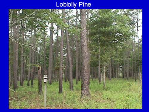
The current management objective is multiple use with an emphasis
on forest management and environmental education. Today, the site hosts
a number of demonstrations including different harvesting and regeneration
combinations (Figure 3); stand maintenance through
thinning, prescribed burning, and salvaging (Figure
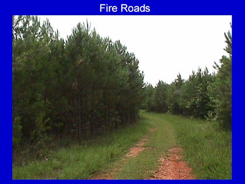
4); fire control through roads and fire lanes (Figure
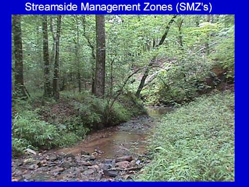
5); environmental protection through streamside management zones (SMZ's)
(Figure 6); and different wildlife management techniques.
The soils of the site are identified as Pacolet (a fine, kaolinitic,
thermic Typic Kanhapludult) or Toccoa (a coarse-loamy, mixed, active, nonacid,
thermic Typic Udifluvent) soil types with low to moderate slopes and are
moderately productive for forests (McNutt 1981). The site consists of a
number of different stand types including pine sawtimber, hardwood sawtimber,
planted loblolly and longleaf pine, natural regeneration, and SMZ's.
GIS Development
ArcView 3.1 running under Windows 98 was selected as the software with
which the GIS would be developed. It was felt that the ArcView Internet
Map Server (IMS) 1.0a software extension would provide the appropriate
web based capabilities for ArcView to met the project objectives. The GIS
facilities of the School of Forestry and the Alabama Land Resource Information
Center (http://www.ag.auburn.edu/aaes/alrichome/) were used to generate
the following themes:
-
Site Boundary
-
Streams
-
Roads and Trails
-
Soils (with some soil attribute information derived from the soil survey
[McNutt 1981])
-
Stands (with cruise data in the attribute data base)
A project containing two major views, soils and stands, was created using
a combination of these themes. Internet serving of the resultant project
was attempted using the PFMT's NT server running the Microsoft Internet
Information Server software. This resulted in the server becoming unstable
and the project was eventually served using my PC running the Microsoft
Personal Web Server for Windows 98.
RESULTS AND DISCUSSION
ArcView IMS was capable of serving the project over the web. Using ArcView
IMS, I was able to display the two views (soils [Figure
7] and stands [Figure 8]), interactively select
themes (Figure 9), and interactively view attribute
data. ArcView IMS, as delivered by Esri, did not allow for interactive
spatial query across the web. For example, trying to develop a theme of
the co-occurrence of Pine sawtimber on the Pacolet soil type or the percent
occurrence of stand types within a 20 yard buffer from a road was not possible.
In fairness to Esri, it was never claimed that ArcView IMS had such capabilities.
I was in error in assuming it did.
ArcView and ArcView IMS were found to be a user friendly environment
in which to develop and display views. I was able to serve views in which
a user could interactively select themes for display. Manipulation of the
html code produced by the ArcView IMS extension has allowed me to link
other html and .pdf documents to my views and/or surrounding frames. I
experienced problems in trying to get ArcView IMS to keep from "crashing"
a server running Microsoft Internet Information Server software on an NT
server. I am still trying to resolve this issue. Finally, I was disappointed
to learn that I was not able to develop spatial queries using ArcView IMS.
Discussions at the 1999 Esri User Conference suggest that there may be
a set of tools to develop such queries. Such tools would extend the utility
of the ArcView IMS product and help me in trying to get others to answer
primary question of concern that I attempted to address - Do I need
a GIS?
CONCLUSIONS
The combination of ArcView and ArcView IMS allowed me to meet some of my
objectives. Specifically, I was able to develop a method to interactively
display various themes within a view, create links to other html and .pdf
documents, and highlight the Mary Olive Thomas Demonstration Forest. I
was not able to develop a mechanism whereby users could perform interactive
spatial queries themes. The inability to do this made it impossible for
me to meet the primary goal of this project which was to have individuals
answer the question - Do I need a GIS? One way around this shortcoming
would be to prepare a series of "canned" spatial queries that would guide
the user through a typical query and present a series of views that show
the output of such queries.
Recognizing that I may have chosen the wrong set of tools to address
my objectives, I plan to investigate the utility of other Esri IMS products
in addressing these objectives. Having developed the basic framework of
the GIS, I plan to develop links to other relevant documents within the
view frames (i.e., links to photographs and other site data, metadata,
and sources of additional information using ArcView IMS. For example, when
users click on a longleaf pine regeneration stand type, there could be
a link to the Longleaf Alliance (http://www.forestry.auburn.edu/la/).
When the ArcView IMS software is installed in such a way that it no longer
crashes the server, the results of the research will be accessible through
the PFMT site (http://www.pfmt.org/).
ACKNOWLEDGMENTS
I would like to acknowledge the following individuals for their contributions
to this project: 1) John Beck, Manager of the Alabama Land Resources Center;
2) Tim Bottenfield, Director of Information Systems, Auburn University
School of Forestry; 3) Roxanna Dean, Information Technology Specialist
and webmaster, Private Forestry Management Team; and 4) Louis (Pat) Smith,
formally a graduate student in the School of Forestry, for his initial
spatial data base creation.
REFERENCES
[FPDC] Forest Products Development Center. No date - a. Alabama's forest
resource [Online]. Available: http://www.forestry.auburn.edu/fpdc/alforest.html
[1999, August 11].
[FPDC] Forest Products Development Center. No date - b. Alabama's
Forest Products Industry [Online]. Available: http://www.forestry.auburn.edu/fpdc/alforind.html
[1999, August 11].
McNutt, R.B. 1981. Soil survey of Lee County, Alabama. [Washington,
D.C.] : U.S. Dept. of Agriculture, Soil Conservation Service.
[PFMT] Private Forest Management Team. 1999a. Introduction [Online].
Available: http://www.pfmt.org/ [1999,
August 11].
[PFMT] Private Forest Management Team. 1999b. Forest management
planning [Online]. Available: http://www.pfmt.org/planning/
[1999, August 11].
Mark D. MacKenzie
Assistant Professor of Forest Ecology
School of Forestry
Auburn University, AL 36849-5418
Phone (334) 844-1014 Fax (334) 844-1084
mackenzi@forestry.auburn.edu