Monmouth County GIS Implementation
"The Good, The Bad, and The Ugly"
by
Robert S. Berardo
Monmouth County GIS Coordinator
Abstract
"The Good, The Bad, and The Ugly"
Development of a multi-participant Enterprise GIS program
Robert Berardo
Monmouth County, NJ, took on the development of a vast enterprise GIS program for its political area. To make the system as complete and useful as possible it was determined that as many organizations as possible needed to participate. Unfortunately though, when you have this many participants the concerns, issues, and headaches are only multiplied by the number of participants. This paper looks at the issues, problems, concerns, and successes realized by New Jersey’s leading GIS organization.
Mr. Berardo, is the GIS Coordinator for Monmouth County, NJ. He has worked in the GIS field for ten years and has been a major influence in the New Jersey GIS community. He is responsible for overseeing the daily efforts within the Monmouth County GIS Management Office and speaks frequently with organizations interested in GIS development. Currently the Monmouth County GIS program includes 15 County agencies, 30 local (municipality) government entities, and 12 state, federal and private organizations. He is also an adjunct professor at Monmouth University, and Brookdale Community College.
Monmouth County GIS Implementation
The Good, The Bad, and The Ugly
Introduction
The Monmouth County GIS Management Office (MCGISMO) is a division of the Information Services Department. MCGISMO is a service organization developed to coordinate, manage, maintain, and distribute the County’s digital geographic information and related technology.
MCGISMO is a service-oriented working environment and is dedicated to providing expertise, support, and assistance to County agencies, townships, boroughs, cities, and the general public. MCGISMO is a mechanism to insure the link between GIS technology and its relationship to effective and efficient business functions occurring in County agencies and municipalities.
GIS in Monmouth County, NJ "The History"
Monmouth County’s continued growth has placed an increasing burden on the County government’s performance of its functions. To cope with the expanding demand for services, the County has increasingly employed computer systems to increase staff productivity. The development of geographic information technology is a strategic activity within Monmouth County. Approximately 90 percent of the data maintained by local government are referenced geographically.
The Monmouth County Geographic Information System (GIS) Program has grown in a few short years from a single project oriented effort in one county department to a multi-department, multi-user enterprise program employing numerous software packages and data layers. In that time, GIS has become intertwined into many aspects of county government and the use of GIS has become commonplace rather than the exception. Because of its vision, successes and guidance the Monmouth County GIS program is considered one of the leading GIS efforts in NJ.
Monmouth County’s GIS effort was initiated in 1991 through an initial state grant within the County Environmental Health Act (CEHA) in the county Health Department. From 1991 through 1994, the Health Department’s program operated on a project basis, with the system creating, manipulating, and analyzing data for a single project at a time. A lot of staff time was spent relearning how to use the system and identifying data needs. The Health Department selected Esri’s Arc/Info and ArcView as its platform of choice. In 1994 the department created the position of GIS Specialist to oversee the department’s growth and management of GIS-based projects. This began the expansion of GIS into all aspects of the Health Department including projects in both public and environmental health.
From 1992 through 1994 the County Planning Department began getting involved with GIS technology. GRASS software was used for projects in its Farmland Preservation Program. The Transportation Division of the Planning Department had begun using MapInfo, and the Environmental Planning Department began using ArcView. All of these sections of Planning saw the usefulness of GIS and began to identify specific applications for their unique needs.
The growing popularity of GIS among different departments, each with varying needs and capabilities, carried the risk of overlap and redundancy. Thus the County Freeholders saw the need to form a Steering Committee in 1992-93 to guide the development of a centralized GIS program. Currently the Committee is composed of representatives from Information Services, Parks, Planning, Health, Emergency Management, Engineering, and Police Radio. Designed to focus the work of the GIS program and users, the Steering Committee’s role is to develop priorities, set direction, and guide GIS development.
In 1996, the County Freeholders made the commitment to begin the implementation of a centralized GIS effort. A GIS Coordinator was hired to oversee the implementation and develop this program. A centralized GIS office was created, the GIS Management Office (MCGISMO), and placed in the County’s Information Services Department. The creation of this office has allowed staff to develop an overall implementation plan for all county agencies, to manage major data development projects and the distribution of data, and to develop standards and methodologies. To further ensure consistency, the GIS Steering Committee formed a Technical Subcommittee in 1997. This subcommittee works closely with the GIS Management Office to develop digital data standards, metadata standards, and specifications for data development proposals.
The rationale for developing the Monmouth County program is much the same as has been discovered across the country for both municipal and private entities using GIS. For one, data is secure in a GIS environment, where it is well organized and accessible to employees throughout the organization. Because data is well organized, it is easier to search for, analyze, and access for presentations to others. Redundancy and other problems associated with having multiple hard copies of maps and related information is largely eliminated, speeding up the process of map production and revision. Employees are more productive and the workplace becomes more efficient.
Furthermore, GIS revises the way in which users of information can access and make use of that information. Before the advent of GIS, information users were forced to locate data in what has been termed "information islands." Someone interested in retrieving all existing information about a particular parcel in township X would have to visit multiple sites, such as the planning board office, the engineering office, the town administrator, the police and fire departments, and others in order to acquire all existing information relevant to that parcel. At the end of that search, the records and maps would then be pulled together and analyzed.
With GIS, all of that information ideally will have been pulled into a single "data mainland." The person searching for information about a particular parcel in township X conceivably can now ask for a map (or maps) and related records for that parcel and the GIS can deliver the information in a single package, reducing time, redundancy, paperwork, and cost.
Multiple factors account for this success. First and foremost, GIS staff has engaged the support of County Freeholders, who have continuously supported, funded and allowed the program to grow. An active GIS Steering Committee has helped keep all GIS users throughout various departments on track. This has allowed a two-way "street" of communication, whereby the departmental users have become increasingly educated on GIS uses and applications. Public exposure through municipal libraries and the Internet has increased the program’s exposure and highlighted its successes. The GIS Management Office has encouraged private organizations / utility companies / non-profit organizations / outside agencies interest and access, as well as identifying public access and use possibilities.
For the future, the county has an ambitious plan for developing, implementing, and maintaining an ongoing County-wide GIS program. The initial program, Phase 1 , startup in 1997 has been completed. Phase 2, wherein GIS use and standards are identified, is ongoing, and was also completed in 1998. The full GIS implementation program for all county departments (Phase 3) is presently underway and is expected to be completed in mid - 2000. The 18-month Phase 4 marks county-wide implementation, which is to occur between 2000-2001. Phase 5 will mark the ongoing maintenance and management process.
Monmouth County has developed an aggressive timetable for the full development of the GIS program. But at the same time has worked very hard to eliminate redundancy and wasted steps in the process. To develop a successful GIS program, the county will continue working closely with the municipalities, state, and federal agencies, as well as continue the development of applications and data that support, enhance, and advance the efforts of Monmouth County.
The County quickly identified a number of areas in which the GIS effort would create effective and efficient applications. These areas included County Tax Mapping, Planning and Land use, Election Board and Voter Information Tracking, Engineering and Public Works, Emergency Response, Environmental and Public Health, and Environmental Decision Making. A number of these areas over lapped with Municipal GIS areas of interest but some unique areas were also added including School districting, and Municipal Administration.
Monmouth County Implementation Plan
The Monmouth County Implementation plan covers four major areas. The creation of a coordination office (MCGISMO), County Departmental Access, Municipal Access, and Education/training. Each area has unique issues and design concerns but a common need for coordination and support.
MCGISMO
MCGISMO is charged with the leadership role of GIS development and management by the County Freeholders. This office over sees six main areas including the development of the GIS network, working with the GIS Steering committee to identify and develop a universal GIS data set, and developing a set of digital data standards. MCGISMO also over sees the development of user applications, developing and implementing a training and education program, and developing an implementation plan for the entire program.
Mission Statement
"It is the mission of the Division of GIS (MCGISMO) to encourage and support the continued development and growth of GIS, through the use of updated /current shared data and resources within Monmouth County and New Jersey."
Division’s Role
"The Division’s role is to coordinate, support, teach, and lead the development and maintenance of GIS data, serve as a data clearinghouse, promote conformity and establish data development standards for all GIS users throughout Monmouth County."
Goals
Implementation Phases
MCGISMO identified five (5) different phases for the implementation of GIS within Monmouth County. They include:
(Jan.’97 – Dec. ’97)
(Jan. ’98 – Dec. ’98)
(Jan. ’99 – July ’00)
(July ’00 – Dec. ’01)
(Jan. 2002)
County Departmental Applications
Monmouth County GIS Application Development
County Tax Mapping
The County is presently undertaking the development of a Countywide Cadastral layer. The Cadastral data is created from 250,000 + tax parcel and will be linked with the existing tax database. The tax maps are scanned into the GIS system and registered to the County Land Base. Centroids are developed and linked with the County tax data base (MODIV). Municipalities are also participating in the data development project and are presently developing application to utilize this data when it is complete (fall 1999). County and Municipal applications include quick queries of land value, multiple ownership, recent sales, and open space inventories.
Public Safety Applications
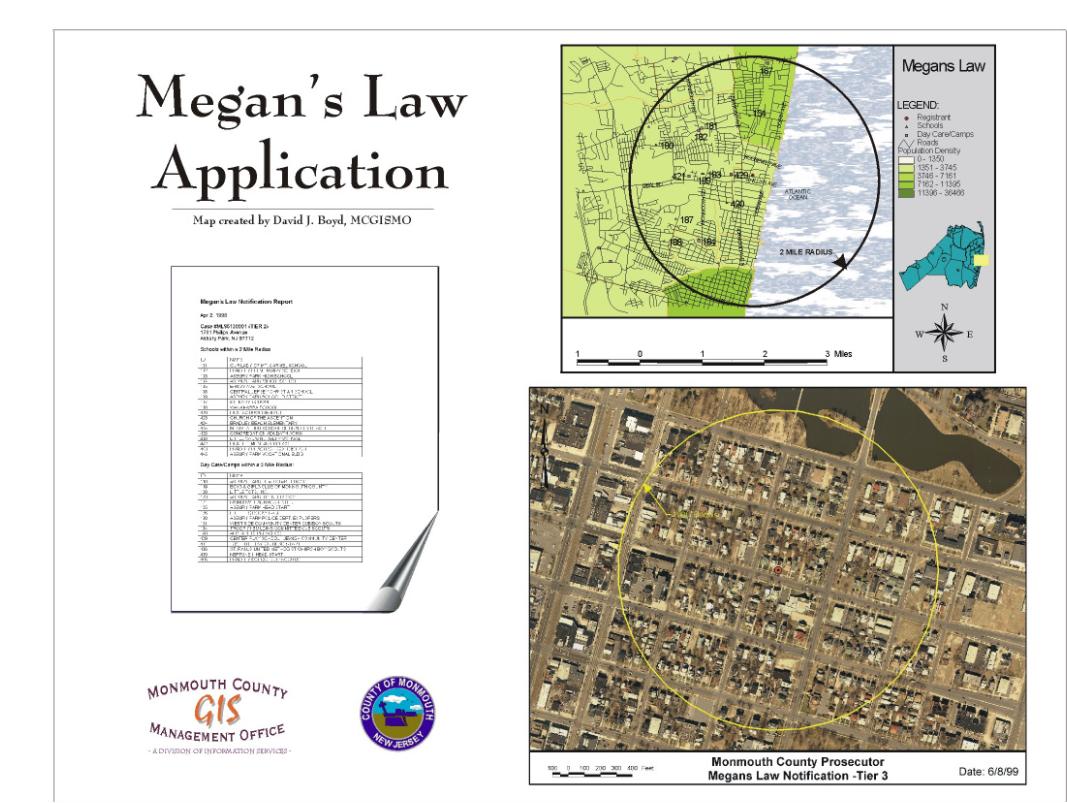
The County Prosecutors Office was charged with developing a methodology to register sex offenders under the New Jersey Megan’s Law. The MCGISMO staff developed an application which integrated existing GIS information and site specific data collection. Output included the necessary mapped information and a report generated for mail notification.
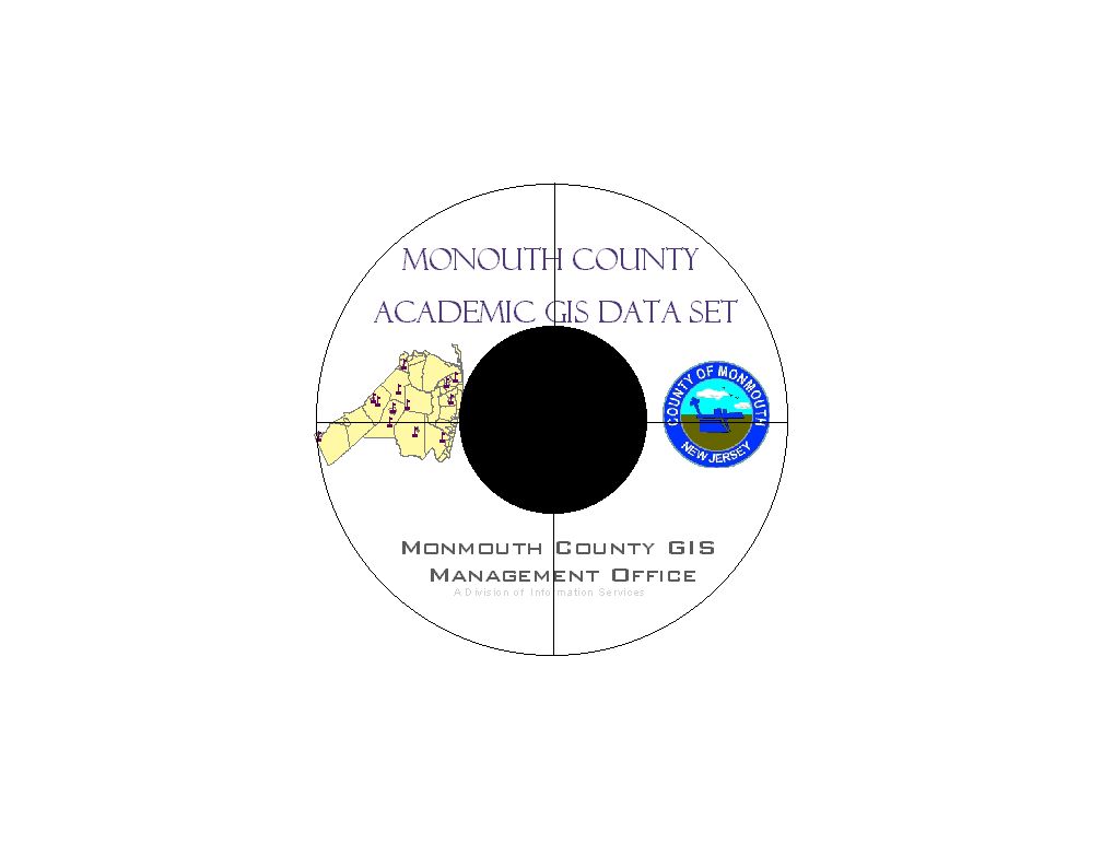
Academic Partnerships (Education and Campus Management)
The County continues to expand its array of partners. The Academic community has long been involved with GIS and MCGISMO believes in teaching what it is doing as well as completing the projects. Recently the MCGISMO staff began working with Monmouth University in West Long Branch. The beginning of a GIS Certificate program is underway and the University has begun utilizing GIS for Facility Management.
MCGISMO also works very closely with the K-12 academic community. A recent project included assisting Freehold Regional High School District with the development of a GIS curriculum in Social Studies and Science areas.
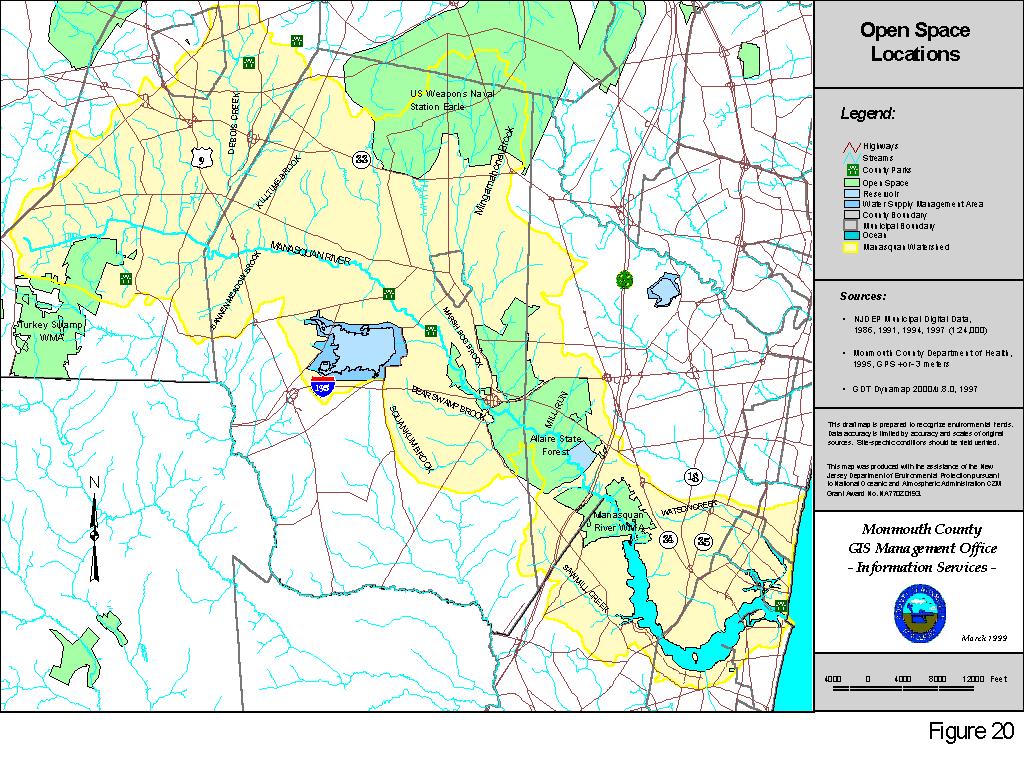
Environmental Decision Making
Monmouth County encompasses 482 square miles and is divided into nine (9) watershed areas. Many of the County agencies are charged with developing useable programs based on Watershed issues. The MCGISMO staff works in a supporting role with each of the departments including Health, Planning, and Mosquito Commission. Applications are developed for recharge/runoff calculations, Rapid Bio-assessment, facility inventory and impact issues, and Watershed Characterization and Assessment.
Public Information
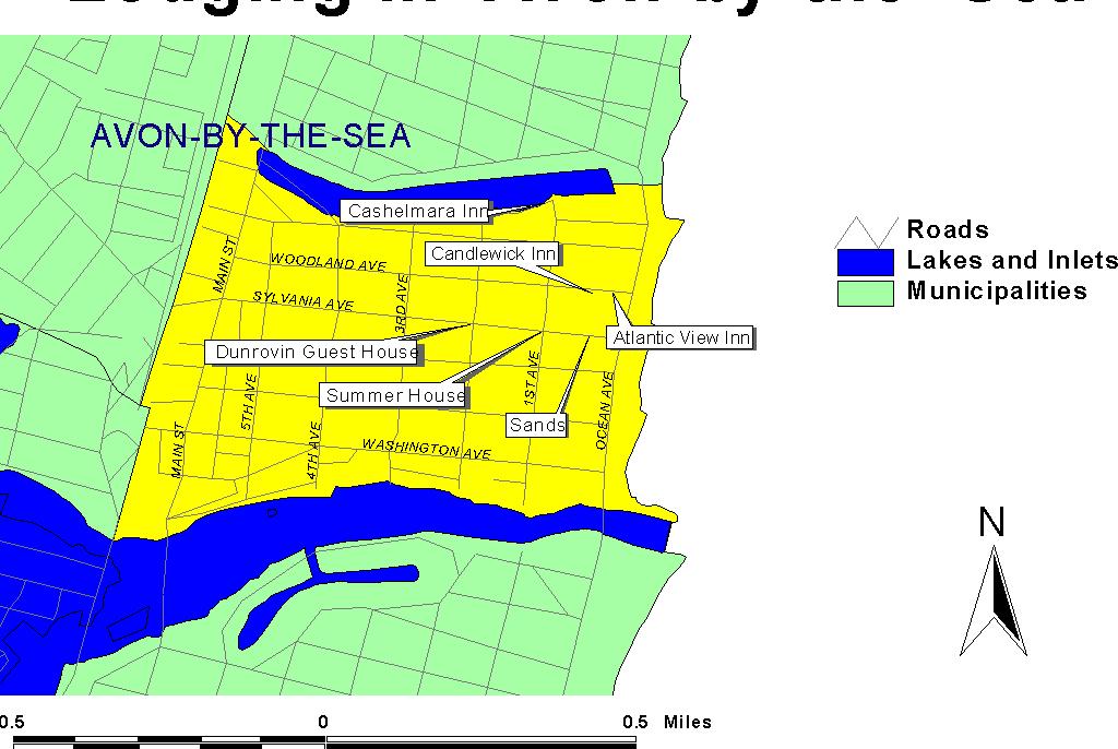
GIS has been used to inform the public about locations of vacation spots in many regions. In Monmouth County the GIS assists tourist interested in lodging locations along the Jersey shore. This application is static at this time but intentions are to create an interactive version.
Recreational Information
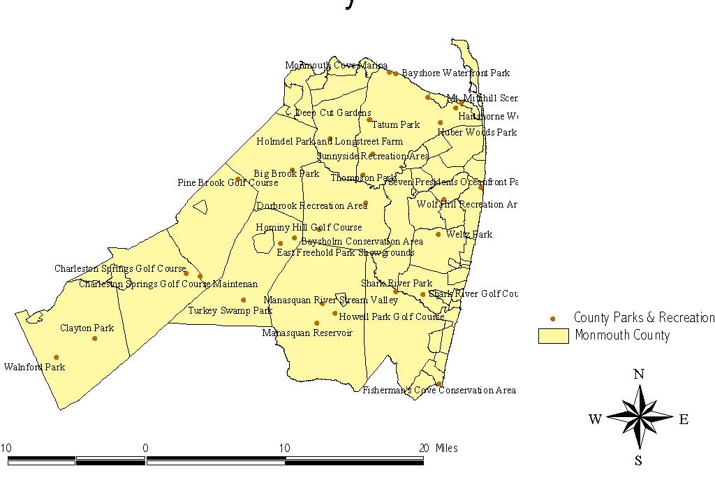
Early uses of GIS in the County included work in the Parks & Recreation areas. Monmouth County’s first GIS (non-digital) were a series of mylar overlays indicating environmental features of County park lands. Today the GIS are used as a facility management tool as well as an information gathering and dissemination program. The GIS assists in the designing of park property and the acquisition of this open space.
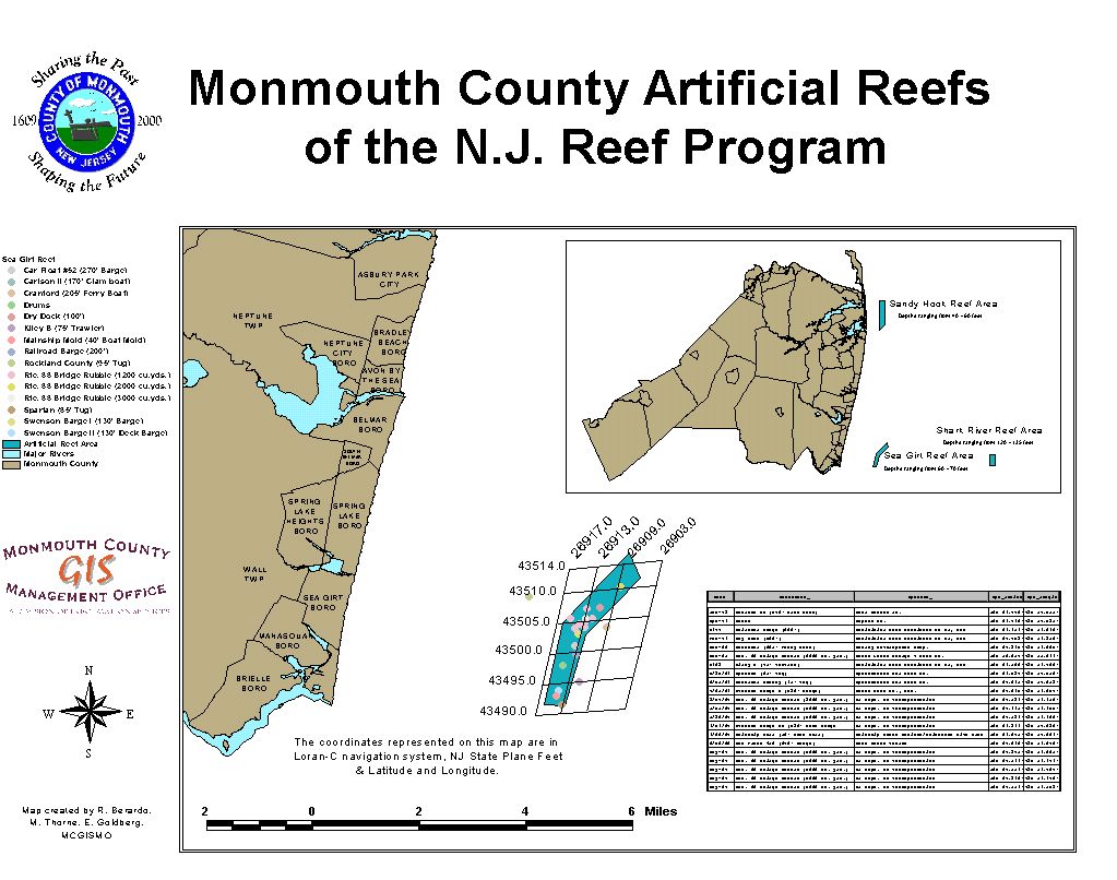
Other recreational areas generate application development. One of Monmouth County’s leading tourist interests is the Atlantic Ocean. Both recreational and commercial fishermen utilize this resource. The State of New Jersey has developed an artificial reef program. MCGISMO developed a series of maps showing the locations, in a number of coordinate systems, of these sites. The maps also described the makeup of the reefs and the supporting organization.
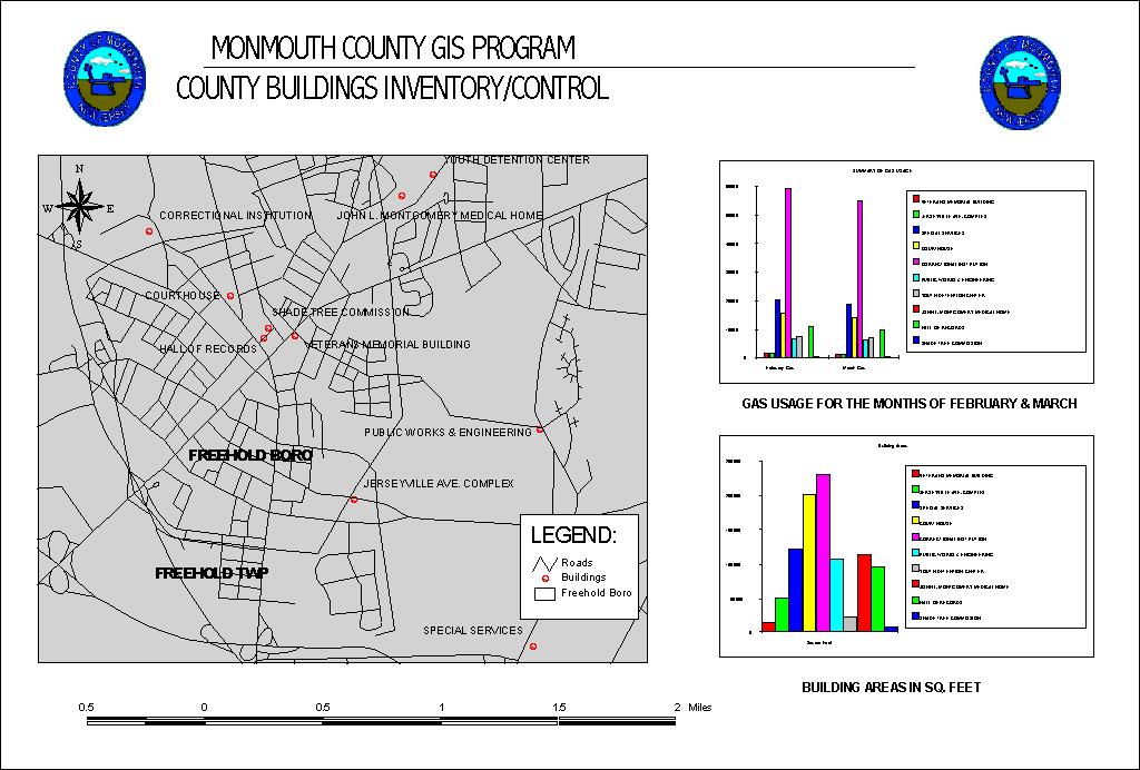
County Management
In New Jersey the deregulation of electrical power has caused the development of a new GIS application. Monmouth County’s buildings & grounds department is investigating bidding for electrical power. A GIS application is being developed to assist them in this effort. Building efficiencies and loads are being collected as well as traffic and street light needs. This will enable the department managers the most effective and efficient methodology to assure success.
Keys to Success
The following are the thirteen (13) keys to Monmouth County’s success in developing an enterprise wide (Countywide) GIS program. These are just suggestions. Utilize ones that fit your specific issues and good luck.
"The Good"
An elected Official or other important representative who understands, has vision, can envision, and will take action.
A Conceptual Design and Implementation Plan
Both financially and philosophically
Highly visible
Of interest and concern of the champion
Assured a win-win scenario
"The Bad"
Operational Budget
Staffing Budget
Capital Budget
To assure funding
Make everyone feel warm and fuzzy
Questions and Challenges on accuracy
Newspaper articles "Is this Big Brother Watching?"
"The Ugly"
GIS is not mandatory!
GIS does not fix something that is not broken!
GIS does not need to replace other operations!
GIS is expensive!
Justify every expenditure
Identify benefits for every expense
"The Ultimate Key"
Complete every project professionally and efficiently and of course with a smile (No project is too small or too insignificant).
Measurement of Success
When the "Client" states I’ll be back. And does come back time and time again.
Summary
GIS development is possible. GIS development is hard, it will not do it itself, but it can be done successfully. The Monmouth County GIS program though in its toddlerhood of development has had many successes. We have been blessed with the continuous support of our elected officials (freeholders) and our administration. Our departmental leaders have also been open to this innovative technology. With continued support and leadership from Esri we can only see more positive advances on the horizon.
But even with the success, more work is needed. In the next few months the implementation plan, users needs assessment, and divisional strategic plan will be reviewed, updated, and created. Adjustments are planned for the expansion to a larger geo-database, as well as more access issues. Updated Countywide data development projects will also be planned for the Land Base data, Cadastral data, and other important data layers. New applications are currently being identified and a priority listing will be developed. And new partners will be explored for many aspects of the GIS program.
Acknowledgements
To the entire Board of Chosen Freeholders of Monmouth County, NJ.
Harry Larrison Jr., Freeholder Director
Thomas J. Powers
Theodore J. Narozanick
Amy H. Handlin
Edward J. Stominski
To the Administration and Management leaders.
Especially:
Mr. Robert J. Collins, County Administrator
Mr. Mark E. Acker, Director of Finance Dept.
Mr. F. Robert Williams, Director of Information Services Dept.
Mr. Spencer H. Wickham, Chairman GIS Steering Committee
for their guidance and wisdom on the development of this new program.
The entire staff of MCGISMO, for their constant support and advancements of GIS.
Michael Thorne
Andrea Gibson
Anita Morrison
To all the Interns who have assisted in the development and expansion of the GIS program (a list to long for the page).
And to Esri for answering the hard questions.