
Florence L. Wong, Stephen L. Eittreim, Carolyn H. Degnan, and Wilson C. Lee
Paper presented at 1999 Esri International Users Conference, San Diego, California.
Seafloor mapping in the Monterey Bay National Marine Sanctuary by sidescan sonar and multibeam bathymetry has revealed new details about the geology, morphology, and active geologic processes of this region. Collaborative data from physical samples, current moorings, and photographs of the sea bottom are consolidated with new and existing maps in a GIS. Via ArcView, the in-progress GIS provides research project members a view of the relationship between individual data sets and those that are being developed by other project members. As a mature product, the GIS will be published in cdrom format to make data available to assist science studies and to help with economic and social policy-making decisions regarding this protected environment.
Introduction | Base Map Layers | Previous Work | New USGS Data | Accessing the GIS | Acknowledgments | Metadata | References

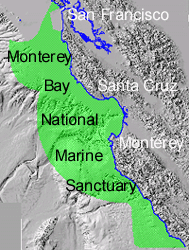
The Monterey Bay National Marine Sanctuary (MBNMS) was established in 1992 to protect and manage the resources of the 13,760 sq km (5300 sq mi) area off the coast of central California. Among the sanctuary objectives are to enhance resource protection, preserve natural beauty, and preserve the bounty of marine ecosystems (MBNMS, 1999).
The U.S. Geological Survey (USGS) initiated a research project in the sanctuary to determine the marine geological environment in which fauna (including homo sapiens), flora, and natural and man-made processes interact (USGS, 1999). Among the questions that the USGS studies will help address are the following:
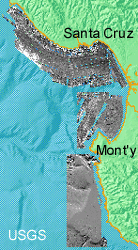
The focus of the USGS study is on the broad, flat continental shelf areas shallower than 200 m (656 ft) between San Francisco to the north and Point Sur to the south. This area is approximately 3,000 sq km (1,160 sq mi) or 20 percent of the areal extent of the sanctuary. The project tasks focus on seafloor mapping, sample collection and analysis, and oceanographic processes.
The data resulting from this research are being compiled in a geographic information system (GIS). This is a progress report to describe some of the data that will be included in the completed GIS.
Basemap Layers
Basemap data layers are essential structural elements in a GIS. For the USGS Monterey project, digital files of coastline, bathymetry, topography, and special boundaries were assembled from published sources where available and from digital files produced in-house. Navigation data (tracklines, time fixes), sample locations, and instrument locations are other base layers that are managed and made available by the USGS Coastal and Marine Geology Program (USGS, 1999). Details on the development of these data layers will be included in the metadata that accompanies the completed GIS.
Previous Work
The compilation of this GIS benefitted greatly from the large body of geological research that has been conducted in the central California region. Detailed onshore geologic maps (e.g., Brabb and others, 1998; Wagner and others, 1999), topography, seismicity catalogues, and stratigraphic studies provide a framework for the newly acquired data and results of the current study.
Seismicity and Faulting
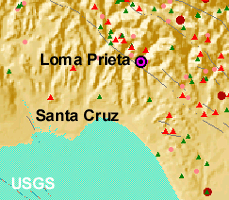
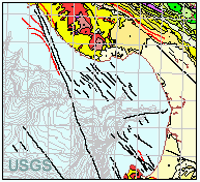
MBNMS is segmented by various faults that are part of the active San Andreas and San Gregorio-Hosgri Fault Zones (Jayko and Lewis, 1996). The epicenter of the 1989 Loma Prieta earthquake (magnitude 7.2; Stover and Coffman, 1993) lies no more than 17 km (11 mi) inland from Monterey Bay. The 1926 Santa Cruz earthquake (magnitude 6.1; Stover and Coffman, 1993) occurred below the seafloor about 15 km (9 mi) west of Santa Cruz, probably along the San Gregorio fault. Acoustic profiling, sidescan images, and micro- (small magnitude) seismicity help refine the locations of traces of the faults in the offshore area. Data from the seismicity catalogues (e.g., NCEDC, 1996) are included in the GIS for this type of structural analysis.
Quaternary Sedimentation
Previous stratigraphic studies (Greene, 1977; Mullins and others, 1985; Chin and others, 1988) based on seismic-reflection data describe the sedimentary structure underlying the newly mapped shelf areas of MBNMS. As much as 33 m (110 ft) of Holocene sediment has been detected in the central mud belt on the shelf. The data from these studies were converted from illustrations in reports and adjusted to uniform depth intervals for the GIS.
LIDAR
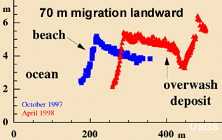
High-resolution laser surveys of the central California coast illustrate coastal change over the 1997-1998 El Niño (USGS, 1998). These studies complement 14 years of beach profiling in the Monterey area (Dingler, in prep.).
New USGS Data
Sidescan Sonar Imagery
Mapping broad reaches of the sea floor requires remote sensing systems much as broad coverage of terrestrial areas does. Analogous to satellite and aerial systems out of the water, sidescan sonar imaging provides high-resolution images of the sea floor by mapping the intensity of sound reflected. A total of 7000 line-km (4400 mi) of sidescan imagery and companion sub-bottom seismic-reflection data were collected by the USGS and cooperators between 1995 and 1998 in the shelf areas between Point Ano Nuevo and Point Sur. South of Monterey Canyon and Moss Landing, multibeam systems were used that provided high-resolution bathymetry as well as sidescan sonar. The sidescan data have been processed and mosaicked into a continuous image of 1,200 sq km (460 sq mi) of the sea floor. The sidescan GIS data layer is a grid built from data with a horizontal resolution between 40 cm and 2.5 m (16 in to 8 ft) with grayscale values proportional to the sonar backscatter of the sea floor (Chavez and others, 1998)
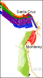
Seafloor Geologic Map
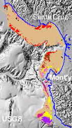
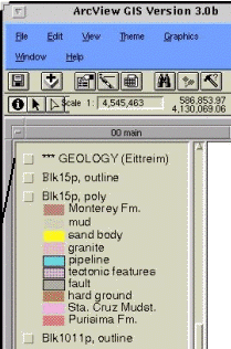
A lithologic map of the sea floor has been interpreted from the sidescan imagery, seismic-reflection profiles, previous work, and sample analyses (Eittreim and others, 1999). The primary lithologic units include the offshore extensions of Cretaceous and Tertiary granitic and metamorphic rocks, Tertiary and Quaternary sedimentary rocks, and Quaternary marine sediments (mud, coarse sand, relict gravel). This GIS data layer consists of polygons identified by lithologic unit.
Sediment Sample Analyses
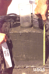
More than 400 sediment samples were collected in MBNMS between San Francisco and Monterey. The box core provides relatively undisturbed samples of seafloor sediment. Plastic cylinders are driven into the box sample to provide material for different analyses of the same sediment. A camera attached to the box corer provides images of the seafloor just before the sampler is triggered. Photographic images of the sea floor and physical samples are used to identify the lithologies that are interpreted on the map of the sea floor. Matching the locations of lithologies identified in photographs to the mosaic provides a key to the type of rocks that particular sonar backscatter intensities are recording. The sediment sample data layers in the GIS consist of locations with a related database table for each of the different analyses conducted on the samples, e.g., grain size, organic carbon content, sediment accumulation rates, foraminifer abundance, seafloor photograph (Edwards and others, 1998).
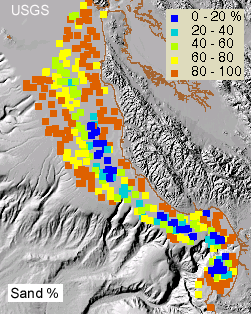
Grain size parameters map coarse and fine deposition on the sea floor. The plot of sand-sized grains (0.063-2.0 mm; 0.002-0.079 in) confirms that finer-grained sediment occupies the central part of the mid-shelf mud belt. Coarser material appears both landward and seaward of the mud belt. The grain size data are included in the GIS as a related database table with grain size parameters as attributes.
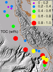
Mass spectrometry provides a geochemical signature of the hydrocarbon component of the sediment containing both marine and terrigenous sources. The amount of total organic carbon (TOC) is less than one percent by weight in selected samples from the study area. The hydrocarbon database table includes as attributes the abundance of hydrocarbon molecules and key weight ratios (Kvenvolden and others, in prep.).
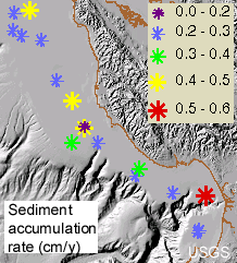
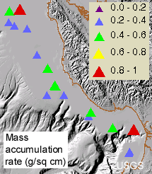
Lead-210 dating techniques can resolve sediment and mass accumulation rates on 100-year time scales. In the sanctuary study area sediment accumulation rates are as much as 0.6 cm/y (0.24 in/y) over the past 100 years. Mass accumulation rates, which are a more accurate measure of sediment accumulation because of variation in compaction, are as much as 0.84 g/sq cm (0.19 oz/sq in) over the past 100 .years (Lewis and others, 1999). Lead-210 profiles for the samples will be included in the GIS database.
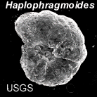
Foraminifers are micro-organisms whose populations are dependent on a number of environmental factors: residence in the water column or in the sediment, water temperature, nutrient and Ca or lithic availability, and currents. Their presence or absence in large or small populations indicate different ecological conditions. The foraminifer abundance database table is related to the sample locations layer with varieties of foraminifers as attribute items (McGann, 1999).
Sea Cliff Photographic Transect
An overlapping series of photographs of the
rugged shoreline between Point Ano Nuevo and Santa Cruz harbor provides
a baseline record of the appearance of this coast the year after the
1997-1998 El Nino event (Chezar and Wong, in prep.). This data layer
consists of locations (navigated by GPS) from which the photographs
were taken and is linked to photographic images.
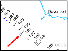
Instrument Moorings
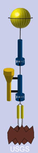
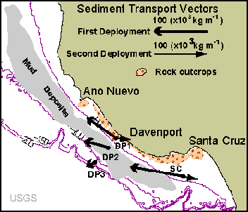
Instrument packages have been set out at several locations along the shelf and Monterey Canyon to record currents, turbidity, sediment accumulation, hydrostatic pressure, salinity, temperature, and water depth. These instruments will provide information about changes over deployment periods of six months to two years (Xu and others, in prep.). The time series data will be summarized and linked to the locations of the instrument moorings.
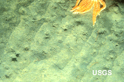
Fluid Seeps
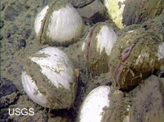
Fluid venting in the Monterey Canyon area is an active process that hosts chemosynthetic 'cold seep' ecosystems (including clams such as those pictured) and may play an important role in world-wide, deep ocean ecology and element cycling (Lorenson and others, 1997). Results from organic chemical analyses of fluid samples will constitute the data layer.
The Monterey sanctuary data have been developed in ArcInfo format as vector coverages, grids or image files in UTM Zone 10 coordinate system datum NAD83. The working GIS has been assembled as an ArcView project. The planned products include a cdrom with a subset of the data and a data page on the project web site. For progress on these products the reader is referred to the USGS Monterey Project web page http://walrus.wr.usgs.gov/mbms
Acknowledgments
USGS Monterey project participants are Roberto Anima, Pat Chavez, Hank Chezar, Carolyn Degnan, John Dingler, Brian Edwards, Steve Eittreim (project chief), Mike Field, Greg Gabel, Pete Galanis, Jim Gardner, Helen Gibbons, Monty Hampton, Fran Hostettler, Fran Hotchkiss, JoAnn Isbrecht, Bruce Jaffe, Jonathan Kolak, Keith Kvenvolden, Wilson Lee, Roger Lewis, Tom Lorensen, Mary McGann, Rani Nandiwada, Marlene Noble, Bill Normark, Jane Reid, Bruce Richmond, Bob Rosenbauer, Stephanie Ross, Holly Ryan, Clint Steele, Andy Stevenson, Jamie Stocking, Curt Storlazzi (Univ. Calif, Santa Cruz), Jim Tait (Univ. Calif, Santa Cruz), Florence Wong, Jing-Ping Xu
Cooperators and other sources of data include NOAA Monterey Bay National Marine Sanctuary, U.S. Army Corps of Engineers, Environmental Protection Agency, Moss Landing Marine Laboratories, University of California, Santa Cruz, Naval Postgraduate School, Monterey, Monterey Bay Aquarium Research Institute.
Andy Stevenson and Michael Hamer provided reviews that helped to improve this paper. Any use of trade, product, or firm names in this publication is for descriptive purposes only and does not imply endorsement by the U.S. Government.
Metadata
Metadata for surveys during which the data in this report were collected are listed below.
J295MB
Santa Cruz shelf (1-4)
J695MB
Santa Cruz shelf (5-7)
M195MB
sampling
M295MB
Santa Cruz shelf (9-11)
P195MB
southern Monterey Bay
P295MB
sampling
J696MB
Half Moon Bay to Santa Cruz
J796MB
southern Monterey Bay
M196MB
Santa Cruz shelf (12-14)
J197MB
Half Moon Bay
J397MB
Santa Cruz to Moss Landing
M497MB
San Francisco to Monterey Bay
J398MB
Half Moon Bay
M198MB
Half Moon Bay to Santa Cruz, photography
J498MB
Ano Nuevo to Santa Cruz, cliff photography
A498MB
multibeam
Brabb, E.E., Graymer, R.W., and Jones, D.L., 1998, Geology of the onshore part of San Mateo County, California: A digital database: U.S. Geological Survey Open-File Report 98-137.
Chavez, P.S., Jr., and others, 1998, Seafloor image map of the Monterey Bay region: http://terraWeb.wr.usgs.gov/tRS/projects/MontereySonar/
Chezar, Henry, and Wong, F.L., in prep., Ano Nuevo to Santa Cruz, California - A photographic survey of the coastline: U.S. Geological Survey Miscellaneous Investigation.
Chin, J.L., Clifton, H.E., and Mullins, H.T., 1988, Seismic stratigraphy and late Quaternary shelf history, south-central Monterey Bay, California: Marine Geology, v. 81, p. 137-157.
Dingler, J.R., and others, in prep., Fourteen-year history of shoreface profiles around Monterey Bay, in Eittreim, S.L., and Noble, M.A., editors, Seafloor Geology and Natural Environment of the Monterey Bay National Marine Sanctuary: Marine Geology special volume
Edwards, B. D., Gardner, J. V., and Stocking, J. L., 1998, Characteristics of surface sediment on the Monterey Bay National Marine Sanctuary shelf - Carmel to the Golden Gate [abs.]: Monterey Bay National Marine Sanctuary Symposium, Sanctuary Currents '98, Human Influences on the Coastal Ocean, Poster Session, Santa Cruz, California, March 7, 1998.
Eittreim, S.L., Anima, R.J., Stevenson, A.J., 1999, Seafloor geology of the continental shelf of Monterey Bay [abs]: American Association of Petroleum Geologists, Pacific Section Convention Program, p. 27.
Greene, H.G., 1977. Geology of the Monterey Bay region: U.S. Geol. Survey Open File Report no. 77-718, 347pp.
Jayko, A.S., and Lewis, S.D., 1996, Toward assessing the seismic risk associated with blind faults, San Francisco Bay region, California: U.S. Geological Survey Open-file Report 96-0267, 188 p., 1 over-size sheet, scale 1:500,000
Kvenvolden, K.A., Rosenbauer, R.J., Hostettler, F.D., and Lorenson, T.D., in prep., Hydrocarbon signatures in the coastal environment of the Monterey Bay National Marine Sanctuary, in Eittreim, S.L., and Noble, M.A., editors, Seafloor Geology and Natural Environment of the Monterey Bay National Marine Sanctuary: Marine Geology special volume
Lewis, R.C., Coale, K.H., Nowicki Douglas, J., Burton E.J., and Edwards, B., 1999, Sediment accumulation rates and depth of sediment mixing in the Monterey Bay National Marine Sanctuary: [abs.] American Association of Petroleum Geologists, Pacific Section Convention Program, p. 48.
Lorenson, T. D., Kvenvolden, K. A., Martin, J. B., Maher, N. M., and Orange, D. L., 1997, Composition of hydrocarbon gases in sediment of Smooth Ridge near Monterey Canyon [abs.]: Monterey Bay National Marine Sanctuary Symposium, Sanctuary Currents '97, Facets of Biodiversity, Poster Session, Santa Cruz, California, March 15, 1997 p 28.
MBNMS, 1999, Monterey Bay National Marine Sanctuary: http://bonita.mbnms.nos.noaa.gov/
McGann, M., 1999, Early 20th century record of microscopic organisms (foraminifers) in Monterey Bay, California [abs.]: Monterey Bay National Marine Sanctuary Symposium, Sanctuary Currents '99, Climate Change and the Sanctuary, Poster Session, Seaside, California, March 20, 1999
Mullins, H.T., Nagel, D.K., and Dominguez, L.L., 1985, Tectonic and eustatic controls of late Quaternary sedimentation along the central California (Santa Cruz) continental margin: High-resolution seismic stratigraphic evidence: Sedimentary Geology, v. 45, p. 327-347.
NCEDC, 1996, Northern California Earthquake Catalog and Phase Data: Northern California Earthquake Data Center http://quake.geo.berkeley.edu/ncedc/catalog-search.html
Stover, C.W., and Coffman, J.L., 1993, Seismicity of the United States, 1568-1989 (Revised): U.S. Geological Survey Professional Paper 1527.
USGS, 1998, Coastal Erosion Along the U.S. West Coast During the 1997-98 El Niño: Expectations and Observations: http://coastal.er.usgs.gov/lidar/AGU_fall98/
USGS, 1999, Monterey Bay National Marine Sanctuary Project: http://walrus.wr.usgs.gov/mbms/
Wagner, D.L., Greene, H.G., Little, J.D., and Watkins, S.E., 1999, Geologic map of the Monterey 1:100,000 scale quadrangle and Monterey Bay: a digital database [abs.]: American Association of Petroleum Geologists, Pacific Section Convention Program, p. 45.
Xu, J.-P., Noble, M.A., and Eittreim, S.L., in prep., Suspended sediment transport on the continental shelf near Davenport, California, in Eittreim, S.L., and Noble, M.A., editors, Seafloor Geology and Natural Environment of the Monterey Bay National Marine Sanctuary: Marine Geology special volume
Florence L. Wong
Stephen L. Eittreim
Carolyn H. Degnan
Wilson C. Lee
U.S. Geological
Survey
Coastal and Marine
Geology
345 Middlefield Road, MS 999
Menlo Park, California 94025
8/6/99