HEC-GeoRAS: Linking GIS to Hydraulic Analysis Using ARC/INFO and HEC-RAS
Cameron T. Ackerman, Research Hydraulic Engineer, Hydrologic Engineering Center, Davis, CA.
Thomas A. Evans, Senior Hydrologic Engineer, Hydrologic Engineering Center, Davis, CA.
Gary W. Brunner, Senior Hydraulic Engineer, Hydrologic Engineering Center, Davis, CA.
Abstract
Although hydraulic analysis can benefit from digital terrain models and other GIS data sets, the complexity and unfamiliarity of GIS programs deters hydraulic engineers from using them. In developing HEC-GeoRAS, the Hydrologic Engineering Center has linked ARC/INFO’s data development and display capabilities to HEC-RAS’s hydraulic analysis capabilities. GeoRAS allows an engineer with little GIS training to use ARC/INFO to develop geometric data for import in HEC-RAS and view exported water surface profile data. The GeoRAS interface provides specific and logical access to ARC/INFO, allowing the engineer to concentrate in hydraulic principles, rather than GIS mechanics, during model development and analysis.
Geographic information systems (GIS) provide a powerful tool for storing, managing, analyzing, and displaying spatially distributed data. Unfortunately, due to GIS complexity, the potential benefits obtained from using a GIS to assist in water-resource analysis are not realized for the inexperienced or infrequent user. Many engineers have had little or no training working with GIS technology, and to perform even simple tasks within a GIS may prove quite burdensome. In the end, the benefits derived by engineers from complex data operations are often dwarfed by the cost of acquiring the knowledge to execute tasks within a GIS.
Hydraulic modeling of river systems may be greatly facilitated with a GIS. Data preparation and model interpretation are time-consuming tasks that can be simplified using a GIS for data processing and display. For the task of river analysis, specific features of a GIS may be made available to the hydraulic engineer through an interface. Providing limited, but logical access to a GIS allows the engineer to concentrate on hydraulic concerns, rather than focusing on the complications of applying the GIS.
The development of HEC-GeoRAS has linked ARC/INFO to the U.S. Army Corps of Engineers Hydrologic Engineering Center River Analysis System (HEC-RAS). HEC-GeoRAS provides a graphical user interface (GUI) that enables the hydraulic engineer to create a HEC-RAS import file containing geometric attribute data from an existing digital terrain model (DTM), process water surface profile data exported from HEC-RAS, and perform floodplain mapping.
HEC-RAS is a one-dimensional, steady-flow, water surface profiling program (U.S. Army Corps of Engineers, 1998). HEC-RAS model construct requires definition of the land surface to be modeled and flow data for hydrologic events. The geometric and flow data are used to calculate steady, gradually varied flow water surface profiles from energy loss computations. HEC-RAS is capable of modeling a full network of channel, a dendritic system, or a single river reach.
Data requirementsHEC-RAS requires the input of geometric data to represent river networks, channel cross-section data, and hydraulic structure data such as bridges and culvert data. At Version 2.0, HEC-RAS introduced the capability to use three-dimensional geometry for the description of river networks and cross sections. Hydrologic events are represented by flow data.
River networks
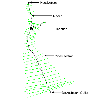
River networks define the connectivity of the river system. A river system is a collection of reaches, all oriented downstream. A reach is defined in HEC-RAS as starting or ending at junctions - locations where two or more streams join together or split apart. A river may be composed of one or more reaches. Depicted in Figure 1 is a general example of a river network with cross-section locations.
Figure 1 General representation of a river network and floodplain.
Channel cross-section data are used in HEC-RAS to characterize the flow carrying capacity of the river and adjacent floodplain. Cross-section data includes station-elevation data, main channel bank stations, downstream reach lengths, roughness coefficients, and contraction and expansion coefficients. Figure 2 provides an example cross-section, as represented in HEC-RAS, identifying bank stations and reach lengths.
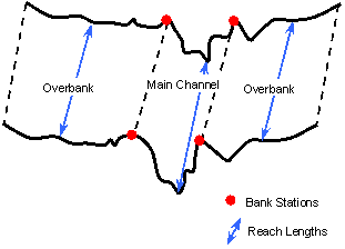
Figure 2 Illustration of channel geometry.
Station-elevation data represent the ground surface at designated locations in a river reach. Cross sections are taken perpendicular the direction of flow both in the main channel and in the overbank areas. Bank stations separate the portion of the cross section that is the main channel of the river from the adjacent floodplain areas termed the left and right overbank areas.
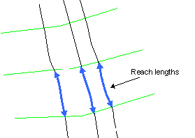
Reach lengths are used to define the distance between cross sections and are used for energy loss calculations in HEC-RAS. Reach lengths are considered for the left overbank, main channel, and right overbank areas and indicate the path of flow between cross sections.
Roughness coefficients are an indication of the relative channel roughness. Channel roughness is considered for calculating frictional energy loss between cross sections. Typically, channel roughness is indicated by Manning’s n-values. Contraction and expansion coefficients are flow dependent and characteristic of abrupt changes in flow direction.
Hydraulic structure data includes data such as bridges, culverts, and weirs.
Flow data
Hydrologic events are represented by flow data. Flow data includes both the flow magnitude (which may vary on a cross section to cross section basis) and boundary conditions. Boundary condition requirements will depend on the flow regime of the model.
HEC-RAS is capable of modeling subcritical, supercritical, or mixed flow regimes. Hydraulic calculations are performed at each cross section to compute water surface elevation, critical depth, energy grade elevation, and velocities.
Topographic data can be imported into HEC-RAS using a data exchange file format developed by HEC. The ASCII file format is based on key headers to identify geometric information, and may be created or read using any GIS. The GIS data exchange file formats appear in Appendix B of the HEC-RAS User’s Manual (U.S. Army Corps of Engineers, 1998).
HEC-RAS import
HEC-RAS (Version 2.2) supports the import of the basic description of the channel geometry, including the structure of the stream network, as represented by interconnected reaches; and the location and description of cross sections. The import file contains river, reach, and station identifiers; cross section cut lines; cross section surface lines; cross section bank stations; and downstream reach lengths for the left overbank, main channel, and right overbank. Roughness coefficients and hydraulic structure data are not written to the import file. Figure 3 is an HEC-RAS schematic of an imported river network.

Figure 3 Imported HEC-RAS schematic
HEC-RAS export
Version 2.2 of HEC-RAS has the capability of writing out simulation results. Cross-section data are written to the export file as cross section cut lines and cross section surface lines with river, reach, and station identifiers. Water surface elevations for each profile attached to each cross section. The export file also contains bounding polygon information for each profile on each reach. Bounding polygon information is used to define the limits of the hydraulic model. A schematic of exported data is shown in Figure 4.
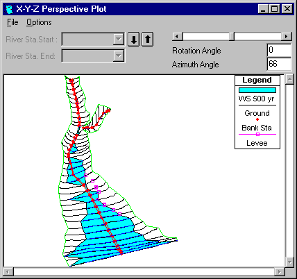
Figure 4 Schematic of exported HEC-RAS results
Geometric data preparationA hydraulic model of a river system depends on the development of geometric data that accurately depicts the land surface to be modeled. GIS provides the tools for storing and manipulating a three-dimensional representation of the land surface as a DTM, and more specifically to HEC-GeoRAS, as a TIN. Provided a TIN of the channel and adjacent floodplain area, linear data sets (line coverages) can be created based on terrain features, and used to develop the required HEC-RAS data components.
Line coverages are data sets composed entirely of lines. In GIS terms, a line is a series of connected points having a beginning and an end. In ARC/INFO, the beginning and end point of each line, or arc, is denoted by a node, while the internal points are termed vertices. Each line also contains attribute data or descriptive information such as length, direction, and connectivity. No two lines in the same data set may intersect.
Geometric data for use in performing river analysis can be developed from a TIN of the land surface and four line coverages. The four line coverages are the Main Channel Invert Coverage, Cross Section Cut Line Coverage, Main Channel Banks Coverage, and Flow Paths Coverage. The purpose for each line coverage in developing geometric data for HEC-RAS is discussed.
Main Channel Invert CoverageThe Main Channel Invert Coverage establishes the connectivity of the river system. Each river reach is represented by an arc and is created with its FROM node upstream of the TO node. Attributes attached to each arc include the river name, reach name, and stationing of the invert. Each reach on the same river must have a unique name. The river system connectivity and attributes represented by the Main Channel Invert Coverage are depicted in Figure 5.
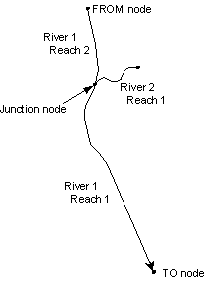
Figure 5 Main Channel Invert Coverage schematic.
The Cross Section Cut Line Coverage is used to define the location of the cross sections and the expanse of the floodplain. Each cut line is constructed from the left bank to the right bank (when facing downstream), perpendicular to the path of water flow. Cross section cut lines are shown in Figure 6.
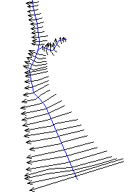
Figure 6 Schematic of cross section cut lines, drawn from the left overbank to right overbank.
The Cross Section Cut Line Coverage is used extract cross-section data. The river name, reach name, and stationing for each cross section are determined by intersecting the Main Channel Invert Coverage with the Cross Section Cut Line Coverage.
Station-elevation data is extracted by intersecting the cut lines with the TIN representation of the land surface. Data points having unique values are extracted along the cut line at each break (side of a triangle) of the TIN. Therefore, station-elevation data may be sampled irregularly, depending on the resolution of the TIN. For example, a TIN created from a data set with few mass points in the floodplain, but numerous mass points in close proximity to the main channel will likely result in a TIN having a dense network near the channel and a less dense network in the floodplain. A visualization of the data extraction process is shown in Figure 7.
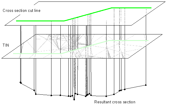
Figure 7 Visualization of station-elevation data extraction from a TIN.
The Main Channel Banks Coverage is use to delineate the portion of cross section that is the main channel from that of the overbank areas. Bank station data is extracted from the intersection of the cross section cut lines and the bank station lines and are expressed as a fraction of the length of the cross section cut line, as illustrated in Figure 8.

Figure 8 Determination of bank stations from the Main Channel Banks Coverage and cross section cut lines.
The Flow Path Coverage represents the path of water flow in the main channel and in the overbank areas. Flow paths are created in the direction of flow, and indicate the center of mass of flow in the left overbank, main channel, and right overbank. Therefore, the different flow path lines may need to be constructed for different flow events. The flow path lines are intersected with the cross section cut lines to determine the downstream reach lengths between cross sections, as depicted in Figure 9.
Figure 9 Determination of downstream reach lengths from the Flow Path Coverage and cross section cut lines.
Results from HEC-RAS simulations may be written to an export file. The text file includes the locations of the cross section cut lines along with water surface profile data and a set of polygons that describe the limit of the floodplain modeled. Profile data are written out as water surface elevations attached to each cross section cut line.
A line coverage of cross section cut lines is created and attributed with water surface elevations. A TIN of the water surface is then generated from the water surface elevations, using the cut lines from the line coverage as breaklines. Breaklines are used to force the formation of triangle edges during triangulation. Shown in Figure 10 is an example water surface TIN created using a line coverage for breaklines.
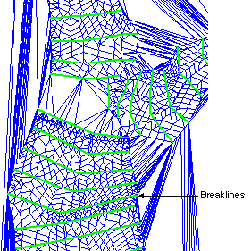
Figure 10 Water surface TIN created using breaklines.
Boundaries for the water surface TIN must then be established to evaluate the extent of inundation. A bounding polygon coverage is created from the boundary data and used to clip the edge of the water surface TIN. The benefits of the bounding polygon are realized between cross sections that are modeled with bridges or levees that are not represented in the DTM. A bounding polygon overlays the water surface TIN Figure 11.

Figure 11 Water surface TIN overlayed by a bounding polygon.
Clipping the water surface TIN with the bounding polygon results in a data set with new boundaries; therefore, a new water surface TIN is created. Figure 12 depicts a water surface TIN created after performing the clipping process.
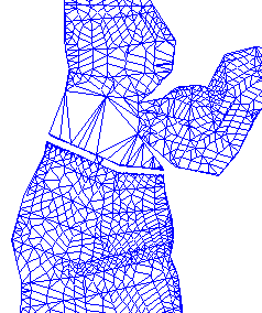
Figure 12 Water surface TIN clipped by a bounding polygon.
Inundation mapping and analysis is then performed by calculations on rasterized (gridded) data created from the water surface TIN and the land surface TIN. The extent of inundation may be viewed as a polygon at the intersection of the water surface and the land surface while and inundation depth may be determined as the difference in elevation between the water surface and the land surface.
HEC-GeoRAS has been specifically designed to aid engineers with limited GIS experience in the development and display of hydraulic data for HEC-RAS. Knowledge of ARC/INFO, ARCEDIT, and ARCPLOT is advantageous, but not necessary to use GeoRAS. While the GeoRAS user environment has been expressly designed to assist users familiar with HEC-RAS, GeoRAS use is not exclusive to HEC-RAS.
GeoRAS provides the user with environments to manage; create and edit; process; and visualize data sets. Each environment is intended to lead the user through procedures in a clear and logical order as summarized below:
Data preparation and management is performed using the project manager interface shown in Figure 13. The project manager is used to establish and manage projects, define the TIN, and provide access to data preparation procedures. As discussed earlier, the user must have a TIN of the terrain to be modeled. The TIN is the data source from which all geometric data will be extracted to input into HEC-RAS. Without a TIN data set, the user will not be able to proceed in using HEC-GeoRAS.
Also, the user may have already prepared data sets using a GIS to use in GeoRAS. They may be selected using the project manager.
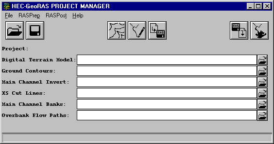
Figure 13 HEC-GeoRAS project manager window.
The data sets used to extract geometric data from the TIN are referred to as RAS Coverages. Before accessing the data editor; however, a contour coverage must be created from the TIN to assist the user in developing model data. Contours are displayed instead of the TIN for two primary reasons: (1) the refresh rate for displaying the TIN can be significant and (2) contours offer an adequate representation of the land surface with relatively few contour lines. The Contour Coverage is used for display purposes only.
RAS Coverage data sets are created and edited using an interactive data editor and display window. The coverage editor is shown in Figure 14.
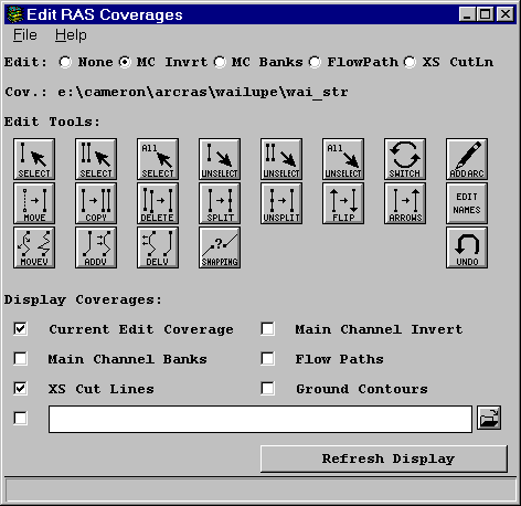
Figure 14 HEC-GeoRAS data editor.
The editor allows the user to create line coverages using a mouse to perform such edits as drawing lines and moving, copying, and deleting lines and vertices, while displaying various line coverages (such as contours) in the background of the display canvas.
The RAS Coverages include data sets that represent the Main Channel Invert, Main Channel Banks, Flow Paths, and Cross Section Cut Lines as shown in Figure 15. The purpose of each data set is discussed below.
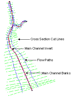
Figure 15 RAS Coverage data used for extracting geometric data.
Main Channel Invert
The Main Channel Invert Coverage is used to define the spatial location (x and y coordinates) of the river and reach network. When intersected with the TIN model the corresponding elevation will be added to the spatial data. The river network is created with line oriented downstream and interactively attributed with river and reach names.
The bank station data at each cross section are defined by the Main Channel Banks Coverage. Bank station values are specified by the intersection of the Main Channel Banks data set with the Cross Section Cut Line data set and indicate the bounds of the main channel from the floodplain.
Flows paths define the center of mass of water flow in the main channel and overbank areas. The Flow Path Coverage is used to determine the reach lengths between cross sections in the left overbank, main-channel, and right overbank. Flow lines are oriented pointing downstream.
Cross section cut lines represent the spatial stationing (x and y coordinates) of cross sections. Cross-section elevation data along each cross section cut line is extracted from the TIN model. Cross section cut lines are oriented from the left to right banks, when facing downstream.
Creating a geometric data file is automated by HEC-GeoRAS. After each RAS Coverage has been created, routines automatically extract geometric data from the TIN model and data sets and write the data to a data exchange file. Routines validate data sets for completeness and indicate program status to the user.
The import file contains river, reach and station identifiers; cross section cut lines, cross section surface lines; cross section bank stations; and downstream reach lengths for the left overbank, main channel, and right overbank. Roughness coefficients and hydraulic structure data are not written to the import file.
The user may choose to extract cross-section elevation data at a specified interval or at each triangle edge. The data extraction method selected by the user is based on the TIN model attributes.
After importing the geometric data extracted from the GIS, completion of the hydraulic data will be necessary. Hydraulic data that are not imported includes roughness coefficients, expansion and contraction coefficients, and hydraulic structure data. Flow data, including boundary conditions must be specified. After running various simulations in HEC-RAS, water surface profile results are exported to the GIS.
Water surface profile results from HEC-RAS simulations are imported into the GIS using a data exchange file similar to the geometric data file discussed earlier. During import, polygon coverages and depth grids are created from the water surface profile data.
Inundation data sets are created from water surface elevation data at each cross-section location in concert with a bounding polygon. The bounding polygon limits the area inundated by water due to such features as levees, bridges and islands, represented in the hydraulic model. Processing of the inundation data sets is described below.
Inundation mapping options are performed using the window interface shown in Figure 16 and allow the user to identify the extent and depth of inundation of each water surface. Background coverages may be displayed along with the inundation data to determine flood prone areas. Example inundation maps are shown in Figure 17 and Figure 18.
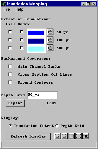
Figure 16 HEC-GeoRAS inundation mapping window.

Figure 17 Inundation polygons for three flood events.
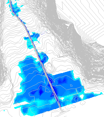
Figure 18 Shaded grid of inundation depths.
HEC-GeoRAS represents a significant advance in linking a GIS with hydraulic modeling. While the integration has been performed specifically for ARC/INFO and HEC-RAS, the GeoRAS software is not exclusive to assisting with hydraulic analysis in HEC-RAS. GeoRAS successful utilizes the GIS technology to develop and refine geometric data for use in river analysis. Results from hydraulic analysis may be displayed in the GIS to establish floodplain extent and evaluate flood depth.
The user environment exemplifies the integration of a GIS to meet the specific needs of engineers less versed in operating a GIS but for whom the benefits of spatial data development, display, and manipulation in river analysis are invaluable. Providing a simple, logical user environment, allows the engineer to view a "real-world" representation of the system under study and, therefore, greatly facilitates modeling efforts by assisting the engineer in making informed decisions and identifying errors inherent in model development.
U.S. Army Corps of Engineers. (1998). HEC-RAS: River Analysis System User’s Manual. Hydrologic Enginnering Center, Davis, CA.
Cameron T. Ackerman, Research Hydraulic Engineer (Email. Cameron.T.Ackerman@usace.army.mil)
Thomas A. Evans, Senior Hydrologic Engineer (Email. thomas.a.evans@usace.army.mil)
Gary W. Brunner, Senior Hydraulic Engineer (Email. Gary.W.Brunner@usace.army.mil)
US Army Corps of Engineers
Hydrologic Engineering Center, Davis, CA.
609 Second Street
Davis, CA 95616-4687
Tel. (530) 756-1104
Fax. (530) 756-8250