
Douglas Henstridge
City of Glendale Land Use Data Management System: Lessons Learned
Abstract
In recent years the City of Glendale has struggled with tracking current land use, and maintaining the correlation between zoned land use and actual use. There was also concern that current use and occupancy data were out of date.
Psomas updated the city’s database using data from third-party sources integrated into a common database, and field verified to validate accuracy. The collected data was then processed to be compatible with the City’s existing Oracle data model. Additionally, applications were developed to aid the City in the management of their landuse data.
The paper will focus on some of the problems and issues encountered, the use of GIS methodologies in finding solutions to those problems, and how the lessons that were learned in Glendale might help other agencies avoid some of the pitfalls associated with this process.
City of Glendale Land Use Data Management System: Lessons Learned
Background
The City of Glendale, California, the third largest city in Los Angeles County, spans over 30 square miles and is home to nearly 200,000 people. Glendale is the third largest financial center in the State and the local economy is dominated primarily by retail and service industries. Additionally, Glendale has one of the highest percentages of multi-family dwelling units of any city in California. Currently, the City is implementing a very successful redevelopment program, which has revitalized its downtown area.
In recent years the City of Glendale has struggled with tracking current land use, and maintaining the correlation between zoned land use and actually use. Additionally, there was concern that their current use and occupancy data files were out of date and no longer valid. The lack of confidence in this data presented serious hurdles to its use for many of the planning division’s mandated planning and community development activities.
The city’s Planning Division considered using GIS technology not only because it offered a solution to the current problem, but also offered additional opportunities for future enhancements and growth. Further, the city already operates and maintains an Arc/Info based GIS system with a complete GIS parcel basemap. This allowed the Planning Division to spatially link its use and occupancy data, without incurring the added costs of landbase data acquisition.
Project Goal
The goal of the project was to provide the city with a database, and application tools that will support numerous functions within the City's planning department, including:
The quality goal for the project was to build a database to 98% accuracy for content and completeness that could be integrated with the current GIS database system. During the project it became clear that it would be impossible to achieve an accuracy of 98%. Due to the frequency of business turnover, and the density of residential development, a quality goal of 95% was deemed to be achievable.
Project Overview
The project began in the fall of 1997. The updating of the city land use database was accomplished using a database processing approach supported by field verification and data collection. A number of third party data sources were acquired, both from Los Angeles County and private data retailers. This data was integrated into a common database, geocoded to the existing parcel basemap, and field verification was conducted to validate accuracy. The collected data was then processed to be compatible with the City’s existing Oracle data model. The database development was divided into four phases.
Development of the Initial Database
The initial database was developed by integrating three third party data sources:
These data sets were merged into a common database file, with a defined data table structure. The City chose not to use its current use and occupancy data, because they had little confidence in the data, and it would have required significant manual data entry.
Once the data file was built, it was validated for conformity with the city's existing GIS data model (P689-1) and an address geocoding methodology was established. Or this first phase of the project addresses would be geocoded on the fly, use a street centerline-based geocoding methodology.
Problems
EncounteredThe database that was created for verification purposes was far more complex than it needed to be. While it appeared to work well, much of the processing was a "black box" to many of the project team members. Additionally, the complexity of the methodology led to the masking of errors, which resulted in significant problems later in the project.
An another problem faced by the project team was the high number of duplicate records that survived the initial database processing. This, coupled with the shear size of the database hid some problems with the completeness of the database.
Field Verification and Geoprocessing
Field Verification
The field verification process relied on a manual procedure of walking the street and visually inspecting each parcel within the defined project area. Low density residential and single family areas of the city were excluded from the project area. The fielders validated each record for:
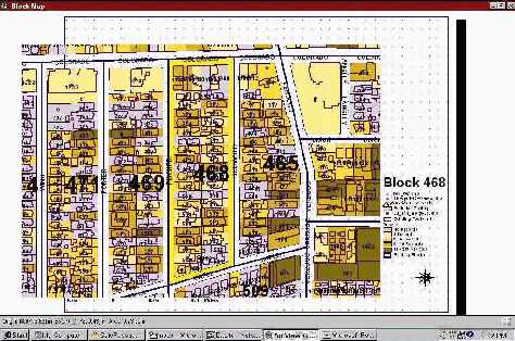
The fielding process was performed on a city block basis. The fielders were provided with a parcel-based block map, which included parcel address and building footprints, and a database report for verification. (see figure P689-1) As a block was completed, it was returned to the office where data entry staff updated the individual records in the database. The updated blocks were then randomly samples and spot checked in the field.
Geoprocessing
Once the records were updated, they were initially geocoded based on a link to the building file. However, this was modified, and records were geocoded based on street address. Once the link to the parcel base was established, the parcel APN and other assessor data were assigned and the usage area and land use range were calculated and assigned.
Problems Encountered
The problems encountered during this phase of the project resulted from two distinct issues; inadequate preparation of fielders for land use verification, a poor linkage to the parcel base.
The fielders selected for this project were not adequately familiar with planning and land use data requirements. Their primary experience was in the field of field utility data collection. Additionally, the field supervisory staff relied to heavily on the fielders past project experiences, which led to errors of judgement and overlooked data. Common interpretations for potential field conditions were not adequately defined in advance.
During the geoprocessing portion of the project a reliance on the link to building resulted in incorrect parcel linkages. The city building footprint coverage proved to be inadequate for the project, and was dropped and a data tool. Instead the land use records were linked physically to the land base as a point theme. This allowed for a visual representation of the individual records, and a spatial join process was used to link the records to the parcel base.
The spatial linkage of the land use points to the parcel base revealed some significant problems with the city's parcel basemap. It was necessary to edit the parcel base before continuing with the project. These data problems should have been identified earlier in the project.
Finalizing the Database
Once the data problems were corrected, the road was clear for finalizing the database. The fielding materials were prepared using ArcView and Crystal reports, and specific parameters were defined for collecting land use data in the field. It was necessary to increase the level of city staff involvement to ensure the accuracy of the final data product.
Applications and Mapping
Internet Application
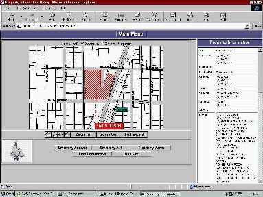
With the database complete, Esri’s MapObjects IMS starter templates were configured to work with the new database to aid the City in the manipulation and maintenance of their updated database. These applications provide inexperienced operators the ability to use GIS capabilities for querying the database, updating data records, and producing map outputs of the results of queries. Additionally, the use of the Internet as an application platform opens the use of the city’s GIS platform to its citizens, allowing for an increase in accessibility to services and information.
By linking individual use and occupancy data to the parcel basemap, the planning division is better able to determine the consistency and density of existing landuse. The Planning Division can now provide this information to other city departments in a format that can be integrated directly into most infrastructure planning and modeling applications (Figure).
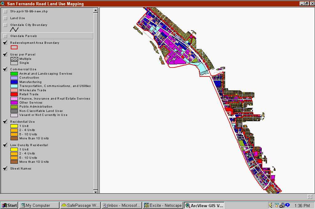
Mapping Needs
In addition to the internet applications, the City's Planning Division also wanted to address the need to produce accurate and detailed existing land use maps to support current community development projects and code enforcement activities. The new database allows the city to produce various land use analysis maps, include land use distribution (Figure), and land use type density.
Where to Next
The city already has an extensive set of geographic coverages supported by a variety of Esri GIS products. Until recently, the use of GIS within the city has been limited to Public Works and Engineering, but as the Planning Division has demonstrated, other potential users in many other city department can benefit from the efforts of the Engineering and IS departments in building the GIS database.
In the near future the City will look at integrating its current use and occupancy permitting process with the new land use data base, building additional application and mapping tools, and continuing to spread GIS awareness throughout the City.
Author Information:
Douglas Henstridge
Psomas
1700 Iowa Ave., Suite 160
Riverside, CA 92507
Tel. 909-787-8421
Fax. 909-682-3379
email: dhenstridge@psomas.com