Authors: Jon Christensen, Matt Carter, Paul Hsiung, and Kirk Bonner
Title: Infiltration/Inflow Analysis Using GIS
Abstract
As regulations change regarding the operation of wastewater collection systems, understanding system performance relative to Infiltration/Inflow (I/I) is a key issue in the development of a collection system master plan. This paper describes how GIS can be used to effectively integrate hydraulic modeling, inspection, and asset data to evaluate potential collection system improvements. Included are specific examples of how ArcView™ and MapObjects™ can be used to view and relate various data sets as well as perform spatial analyses to gain a better understanding of a wastewater collection system's performance.
Introduction
Infiltration/Inflow (I/I) is the term used to describe groundwater and storm water entering into wastewater collection systems through pipe or manhole defects. Some of the defects are due to the age and materials of the wastewater collection system. The I/I enters the collections system through cracked clay pipe and other forms of deteriorated pipe, tree root damage, leaky manhole seals, cracked manhole lid casings, and brick manholes. Pipe and manhole defects are not the only contributors of I/I. Alternative ways for I/I to enter a collections system are attributed to improper or illegal plumbing practices such as: building footing tile drains, sump pumps, building downspouts, or storm sewer discharges that are connected to the sanitary sewer system. In order to analyze a wastewater collection system's I/I problems, data must be collected. The data consists of manhole and pipe inspection information, collections system inventory, and system hydraulic flow information. Once all of the information is collected, it can be stored and analyzed using Black & Veatch's Sanitary Sewer Management System (SSMS) in conjunction with hydraulic modeling software. The process of collecting and analyzing information on I/I is more efficient if GIS information is available. The ability to view the results of the hydraulic model and inspection information in a geographic context is not the only reason for using a GIS. The integration of GIS also simplifies the process of entering inventory data and assigning future wastewater flow data.
Client Needs
Results of an I/I analysis typically lead to a prioritized rehabilitation plan for the wastewater collection system. However, to get the most benefit out of the information used for the I/I analysis the data and model need to be maintained and updated for future analysis of the wastewater collection system. For this reason, it is very important that the data collected be as up to date and accurate as possible, especially the system inventory. The creation and maintenance of the inventory has many benefits beyond I/I analysis, especially if the maintenance is performed in a GIS. Using the inventory data for the integration of paper map production, permit tracking, inspection logging, tax or fee tracking, and maintenance work-order tracking are just a few of the benefits of using the inventory data within a GIS.
Inventory
The wastewater collection system inventory consists of information on pipes, manholes, pump stations, diversions, and siphons. The pipe and manhole information is essential for an I/I analysis. Typically, the wastewater utility will have some type of existing inventory in the form of atlas maps, as-builts or CAD drawings. However, GIS information on collection system is becoming more available as utilities invest it more heavily. If GIS or seamless geo-referenced CAD digital information exists then the majority of the inventory data collection work is complete. If not, work must be done to get the inventory information in a digital, geo-referenced, seamless format, including attribute and inspection data pertaining to pipe diameters, materials, and invert elevation information. A numbering system for the wastewater collection system must be used that ensures no duplicate manhole numbers exist. Graphically, the CAD drawings or GIS layers must have correct topology and connectivity where the sanitary sewer lines connect to the manholes and other structures. Having a collection system in a GIS format has additional benefit since it can be directly imported into SSMS, which allows preparatory QA/QC work to be performed.
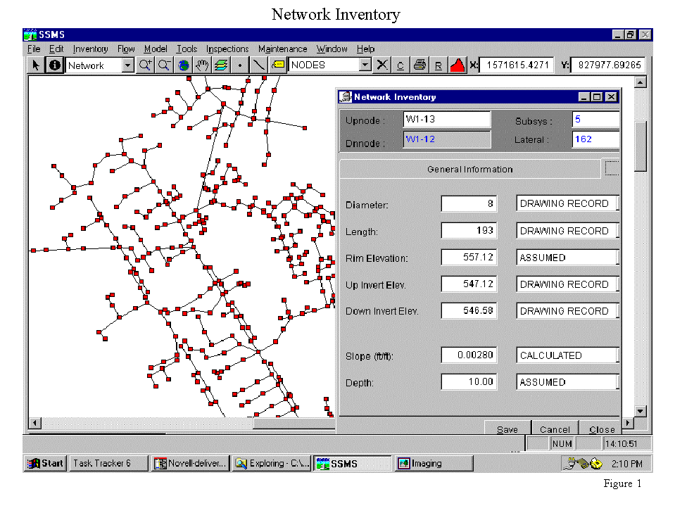
MapObject has been integrated with SSMS in order to assist in the analysis of a collection system. Figure 1 shows an inventory network displayed using MapObjects. MapObjects provides more than just a graphical display platform; it also provides a valuable tool to assist in the analysis of a collection system. Each facet of the I/I analysis is improved by having the ability to display, calculate, and analysis information on a collections systems inventory, wastewater flows, and inspection information.
Flow Analysis and Modeling
Current method of analyzing collection systems wastewater flow characteristics is through a comprehensive flow and rainfall monitoring program. The flow and rainfall information is processed and then entered into SSMS to be applied to the inventory network. However, the flow and rainfall monitoring program only provides the current or existing characteristics of a collection system. In order to analyze how a collection system will react in the future you must have an idea what kind of wastewater flows will the collection system will carry in the future. Future GIS land use information is invaluable, at this point, in determine future wastewater flows.
Once wastewater flow information is determined the flows are applied to the inventory network in a hydraulic computer model. By utilizing proven and effective hydraulic modeling software such as HYDRA, Hydroworks, or SWIM in conjunction with preparatory quality control analysis using Black & Veatch's SSMS, Civil Engineers are able to get the most out of the hydraulic modeling software with a minimal amount of runtime. The results of the hydraulic modeling software are rigorously tested and analyzed to ensure that each subsystem is modeled and calibrated correctly. The quality control/quality assurance part of the analysis utilizes ArcView or MapObjects by allowing the output of the modeling software to be viewed in a GIS System regardless of which hydraulic modeling software is used. The results of the hydraulic modeling are used to develop Capitol Improvement Programs, and also provide the basis for Master Plans that are used to specify all aspects of future management of a sewer system.
Initial Collection System Capacity Analysis
Once the wastewater collection system inventory and flow data have been validated through a calibration process, computer hydraulic capacity analyses are performed. The capacity analyses are performed for various storm events, such as a 1-year or 5- year storm event. This provides information on the hydraulic capacity of the collection system network given frequency of storm events.
Inspections
A physical inspection of the condition of each element of the inventory provides another data set that is needed to develop the I/I analysis. Several different types of inspections are performed to insure that data is gathered about all possible types of problems that may occur in a sewer network. These include manhole inspections, Smoke, Lamping, Dye inspections, and remote control Television Inspections. Typically, personnel that are trained to produce consistent results perform these field inspections, and the results of each inspection are written on a standardized form. These forms are then sent to a central location in the where each separate type of inspection is entered into SSMS's predefined database structure that is designed to support and complement the I/I analysis process.
Defects
Defects are characterized as problems with pipes or manholes that allow I/I to enter the wastewater collection system. The defects are identified by detailed inspections of the collection system. Once the defects have been identified SSMS will assign flow and cost to each individual defect, from a predefined defect flow and cost table, which is discussed in more detail below. Using this method, SSMS is able to store a database of all defects within a sewer network at any given time. SSMS provides a user controlled MapObjects map, so the same functionality is available from within SSMS. Because each defect has a flow attribute, it is easy for the engineer to view only those defects that cause the most flow to be injected into the system. This can provide an indication of where rehabilitation work needs to be performed. Figure 2 demonstrates how MapObjects can display manholes with I/I causing defect.
Prioritization
After the defects determined for a given network, the need to prioritize the work to rehabilitate these defects becomes a requirement. Again, SSMS is used for this task. SSMS provides default values for the cost and flow amounts that should be associated with each type of defect. These defaults provide the ability for an engineer to specify costs based on local averages, and flow values that match or are near known values for a general geographic area. SSMS can then relate these cost and flow values to each of the defects that are listed in the Defects database and prioritize the defects. This prioritization is accomplished by creating a separate "Prioritize" database. The Prioritize database represents a snapshot in time, since it is not dynamically updated like the Defects database is. It will list each Defect, but the order of the defects is such that the defect with the least cost per unit of flow is listed first.

Conclusion
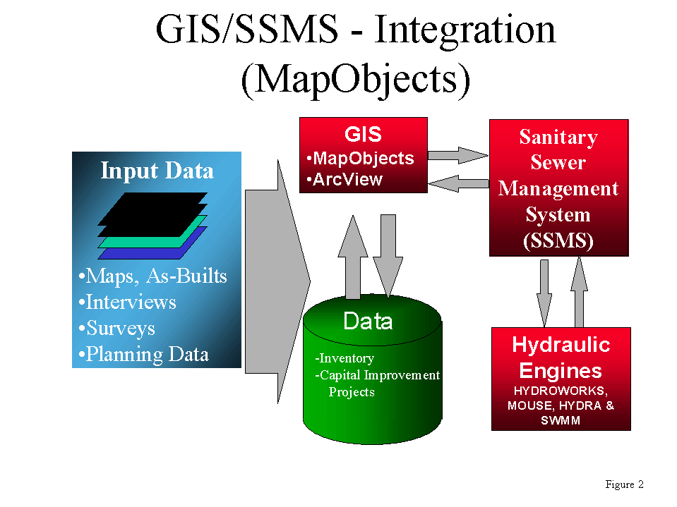
SSMS is used to integrate all the various components of the I/I Analysis process. SSMS provides specialized databases for Inventory, Modeling, Inspections, Prioritization, and other I/I Analysis support databases. In addition, SSMS provides all the automated processes that allow the engineer to easily perform each of the steps required to produce an in-depth I/I Analysis. SSMS provides its GIS features through the MapObjects software object that is available from Environmental Systems Research Institute (Esri). This software object provides a map that can be displayed in the application and numerous additional features that SSMS accesses programmatically to perform it GIS related functions. The relationship with SSMS and GIS is shown on Figure 2. At each step along the path to the I/I Analysis wherein the data is collected, processed, and analyzed, certain QC/QA procedures are necessary. The engineer uses the MapObjects based map in SSMS to view and analyze the results. The GIS features make it easy to spot problems areas in a network and also to identify errors in many cases. It also provides an easy way to integrate each of the different data elements with a GIS interface. For instance, hydraulic modeling results are immediately available through the MapObjects map. An engineer can quickly set the colors of pipes based on their utilization to see what portions of a network are overloaded, as shown on Figure 3. As another example, Inspection results can be used to set the color of pipes and manholes in the map to represent the condition of the inventory.
The collection system inventory is stored as an Esri Shapefile format allows for a quick and relatively easy use of the model output through the SSMS software by the B&V engineers. The ability to add, delete, edit, view, and perform queries with ArcView or MapObjects allows the engineer flexibility in the QC/QA process of modeling. Printing is also a great advantage when using ArcView and its layout capabilities, but MapObjects does have printing limitations. Having the GIS capabilities accessible directly through the SSMS software is also very advantageous. Using property mapping and census layers from the GIS allows the engineer to determine what type of flows that are effected from the areas without relying on extensive field work or guesswork. For helping to determine flow demands for the future, proposed land use GIS layers are used for the hydraulic modeling scenarios.
Prior to the use of GIS, an analysis of Inflow/Infiltration was a massive undertaking and required an extraordinary amount labor without seeing the geographical context. With the advent of PC-based GIS products like ArcView and MapObjects, the engineers at Black & Veatch are able to economically integrate GIS data into their SSMS software. By putting the power of GIS directly into the hands of the engineers, GIS is a tremendous tool used to gain a better understanding of a wastewater collection system's performance.
Jon Christensen
Senior GIS Analyst
Black & Veatch Corporation
Kansas City, Missouri
Matt Carter
Water Distribution Engineer
Black & Veatch Corporation
Kansas City, Missouri
Paul Hsiung
Project Engineer/GIS Manager
Black & Veatch Corporation
Kansas City, Missouri
Kirk Bonner
Project Manager
Spencer Reed Group
Overland Park, Kansas