Jane Frankenberger and Ravi Narayanan
Surface runoff is the primary transport mechanism for many nonpoint source pollutants including pathogens, sediment, and most commonly-used pesticides. The Soil Moisture Routing Model was developed to assist in making watershed management decisions for areas where variable source area hydrology is responsible for a considerable portion of total surface runoff. The model uses ArcView to predict saturation excess overland flow in watersheds with shallow sloping soils. Elevation, soil, and land use information are combined to predict both soil moisture and surface runoff each day throughout the watershed.
Surface runoff is responsible for detachment and transport of many nonpoint source pollutants, including sediment, most currently-used pesticides, and pathogens such as bacteria and protozoa. The prediction of specific areas in a watershed that generate surface runoff, and the amounts of runoff that are generated, can be a first step in improved watershed management.
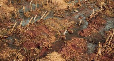
Figure 1: Surface runoff carrying manure and agricultural chemicals from a harvested field
Surface runoff can be caused by at least two different processes, depending on soil properties, antecedent moisture, and land cover conditions. Hortonian or infiltration-excess runoff occurs when the rainfall intensity exceeds the infiltration capacity of the soil. Hortonian runoff typically occurs when vegetative cover is poor, hydraulic conductivity is low, and rains are fairly intense. Variable source area or saturation-excess runoff occurs when the soil is unable to absorb more rainfall because it is already saturated. Variable source area runoff can occur even under good vegetative cover and highly permeable soils.
Variable source areas generate most runoff in humid, well-vegetated areas (Dunne and Black, 1970; Hewlett and Nutter, 1970). Saturated areas often form in areas where subsurface lateral flow converges, the slope changes, or where depth to the restricting layer decreases. Since most runoff in humid regions originates on these variable source areas, an important strategy for minimizing nonpoint source pollution is to accurately identify areas likely to become saturated so that potential pollutant loading can be minimized there
While infiltration-excess runoff is predicted by many currently-used hydrologic models, fewer models are currently available to predict the spatial pattern of variable source areas. The Soil Moisture Routing model is a simple distributed water balance model run on a daily time step, which estimates the probability of saturation-excess overland flow occurring at any point in the watershed. It was developed with the objective of aiding in management decisions in potential runoff source areas of watersheds with shallow soils.
The Soil Moisture Routing Model is described in detail in Frankenberger et al. (1999). The model is "tightly coupled", or "embedded" within a geographic information system, which means that it is written as a sequence of commands within the GIS. It was originally written as a series of Unix commands within the GRASS GIS. This paper describes its integration and preliminary application in ArcView.
The Soil Moisture Routing model is based on a water balance at each time step for each cell of the watershed. Soil moisture content for each cell is predicted, and any moisture above saturation results in surface runoff. Inputs to each cell are daily precipitation and lateral flow from uphill cells, while outputs are lateral flow to downhill cells, percolation into the bedrock, evapotranspiration, and surface runoff.
For each cell,
![]()
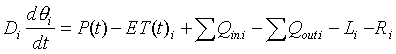
where:
i = cell address,
D i = depth of root zone of the cell
q i = volumetric moisture content of the cell
P = precipitation (rain + snowmelt)
ETi = actual evapotranspiration
S Qin.i = lateral inflow from surrounding upslope cells
S Qout.i = lateral outflow to surrounding downslope cells
L i = leakage out of the surface soil layer to bedrock
R i = surface runoff
The model is run on a daily time step, a compromise between precision and speed for the model objectives of predicting variable source areas.
Subsurface lateral flow
Including shallow subsurface lateral flow, or interflow, as a key component of the water balance is a fairly unique feature of the Soil Moisture Routing Model. Lateral flow causes convergent areas to be wetter than divergent or planar areas, and therefore determines where most surface runoff takes place. The quantity of lateral flow leaving each cell is calculated and this flow is divided among all downhill neighbors as described below.
The quantity of lateral flow out of each cell is calculated from Darcy's Law, approximating the hydraulic gradient by the land slope at each cell:
![]()
where: Qout.i = lateral flow out of cell I, ![]() = land slope of cell I, w = width of each cell, and Ti = transmissivity of the soil profile
= land slope of cell I, w = width of each cell, and Ti = transmissivity of the soil profile
Lateral flow is divided among all cells that are downhill from a particular cell. Allowing flow to divide into multiple flowpaths is particularly important in areas where topography may diverge. Many automatic drainage path algorithms route all downslope flow to one neighboring cell, which tends to lead to accumulation of moisture into channels or gullies more quickly than is actually seen in the field. The multiple flowpath division allocates to each neighbor a portion of the total flow depending on the elevation difference between it and cell i, as well as on the distance between the cells (Quinn et al., 1991). For any neighbor j of cell i,
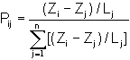
where Pij is the portion of the total flow out of cell i that is routed to neighbor j, Zi and Zj are elevations of cell i and its neighbor j, Lj is the distance from the center point of cell i to neighbor j and n is the number of downslope neighbors of cell i. Unfortunately this multiple flow path routing has not been successfully programmed in Avenue, preventing the model from being completely embedded.
In order to run the model within ArcView GIS using the Spatial Analyst Extension, an Avenue script was written to calculate each of the hydrologic processes described above (lateral flow quantity, percolation, runoff, etc.) and outputs for each cell at each time step. Daily weather inputs are read from a weather table containing precipitation and potential evapotranspiration for each day, which is imported into the project. Soil parameters are read from the data table using the "lookup" function. Actual evapotranspiration is calculated for each land use using a table of crop factors.
The actual lateral flow calculations were not done in Avenue, because of the requirement of routing lateral flow in multiple directions. Grids were therefore exported after the initial calculations, the actual lateral flow routing was done with a C program, and the resulting grid was re-imported. This results in slowing down model running, and further work will focus on either developing of methods to optimize this process, or changing the coding structure.
Embedding the model within the GIS results in easier programming, easy display of intermediate steps, and forces us to think about the relationship between points on the landscape. Unfortunately, at least as currently programmed, the model runs fairly slowly. For large numbers of runs, or for large watersheds with a small grid size, the model would probably run faster if written in a compiled language.
The North Appalachian Experimental Watershed in Coshocton, Ohio, is being used to validate the model under midwestern conditions. The Soil Moisture Routing Model was specifically developed for areas where subsurface lateral flow is an important component of the water balance. Soil types that best fit this model consist of a relatively thin, permeable soil layer over a much less permeable fragipan, bedrock, or other restricting layer. The model is most effective in areas of steep topography, where slopes are significant enough to be the main cause of lateral flow.
Watershed 103 of the NAEW, described in detail by Bonta (1998), has an area of 0.3 ha and an average slope of 11%. Two soil types, Rayne and Coshocton silt loams, both have a fairly permeable topsoil over clay or shallow bedrock. Land use has been pasture since 1975.
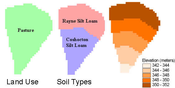
Figure 2: Land use, soil, and elevation for watershed 103 of the North Appalachian Experimental Watershed
Figure 3 shows how lateral flow and moisture storage vary across the watershed on one particular day. The darker areas of the Lateral Flow plot are due to concave areas of the slope and resulting higher moisture content. Lateral flow is strongly dependent on moisture content. Moisture storage depends on volumetric moisture content plus depth of soil. The upper soil type, Rayne silt loam, is generally deeper, although areas further south tend to have higher volumetric moisture content.
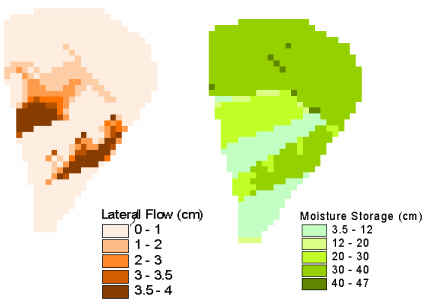
Figure 3: Typical values of lateral flow and moisture storage for watershed 103
Finally, runoff is determined by calculating the moisture excess over saturation at each time step for each cell. For watershed planning, runoff can be summed over an entire month, in order to predict which areas may need special management practices. Figure 4 shows preliminary runoff predictions for this watershed.
Although areas with monthly runoff over 30 cm seem unrealistically high, the average runoff over the watersheds calculated with this model was fairly close to the total on most days (Nash-Sutcliffe efficiency = 0.59). It may be that the conventional means of describing runoff as a spatial average (e.g., "2 cm runoff", when in fact what was measured was 200 m3 over a 1 hectare area) may be unrealistic as well. More data are needed to determine the validity of the spatially varying runoff predictions.
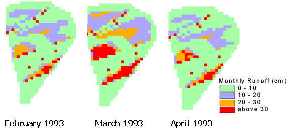
Figure 4: Monthly runoff predicted using the Soil Moisture Routing Model
The Soil Moisture Routing Model uses elevation, soil, and land use data in a simple way to estimate soil moisture and runoff in watersheds with shallow soils. Its use of a GIS to keep track of all parameters and state variables make it easy to use and modify for different conditions. The Soil Moisture Routing Model in its present form can be useful in assisting in management decisions such as location and timing of manure spreading on farms, or choosing the most effective Best Management Practices. Continued work will focus on developing an infiltration component, adding a plotting routine in ArcView, increasing model speed, and further validation on midwestern watersheds.
Bonta, J. 1998. Spatial variability of runoff and soil properties on small watersheds with similar soil map units. Tran. ASAE. 41:575-585.
Dunne, T., and R. Black, 1970. An experimental investigation of runoff production in permeable soils. Water Resour. Res. 6:478-499.
Frankenberger, J.R., Brooks, E., Walter, M.T., Walter, M.F. and T.S. Steenhuis, 1999. A GIS-based variable source area model for shallow sloping soils. Hydrological Processes 13:805-822.
Hewlett, J., and W.L. Nutter, 1970. The varying source area of streamflow from upland basins. In Symposium on Interdisciplinary Aspects of Watershed Management. Montana State University, Bozeman.
Nash, J.E. and J.V. Sutcliffe, 1970. River flow forecasting through conceptual models, part 1 -- A discussion of principles. J. Hydrol., 10:238-250.
Quinn, P., K. Beven, P. Chevallier, and O. Planchon. 1991. The prediction of hillslope flow paths for distributed hydrological modelling using digital terrain models. Hydrological Processes 5:59-79.
Jane Frankenberger
Assistant Professor, Agricultural and Biological Engineering Department
Purdue University
1146 ABE Bldg
West Lafayette IN 47907-1147
frankenb@purdue.edu
Ravi Narayanan
Graduate Research Assistant, Agricultural and Biological Engineering Department
Purdue University
1146 ABE Bldg
West Lafayette IN 47907-1147
narayana@ecn.purdue.edu