Mauro Di Luzio and Raghavan Srinivasan
Filling the Gaps Between USGS DEMs and the USEPA Reach Files
Raster-based elevation data (grid-based DEMs) are very suitable for hydrologic modeling using efficient and useful algorithms for terrain analysis to delineate watershed boundaries and stream networks.
Although these DEMs are available from U.S. Geological Survey with different space resolution, the prevalent discrete elevation resolution still remain a major drawback.
U.S. Environmental Protection Agency's (EPA) Reach Files 3 are a series of hydrographic databases of the surface waters of continental United States, created expressly to provide hydrologic ordering as well as network navigation.
ArcView software was used to develop a set of tools to improve the watershed and stream network definitions matching USGS's and USEPA's databases.
Introduction
In hydrologic studies the determination of watershed subdivision and stream network definition are often required. The procedure for the extraction of network and subwatershed properties is commonly automated based on digital elevation models (DEMs).
There are three principal methods for structuring a set of elevation data, which are: contour-based, triangulated irregular (TIN-DEM) and square-grid (raster) networks (Moore et al., 1991). Using contour based networks, a watershed basin can be subdivided into irregular polygons bounded by contour lines and adjacent their orthogonal (flow trajectories) that define the boundaries of drainage areas (O'Loughlin, 1986; Moore et al., 1988). In the TIN-DEM system the watershed topography is modeled as a set of contiguous no-overlapping triangular facets, each possessing a principal slope and direction aspects (View, 1991). For hydrologic modeling, contour based and TIN methods are successful applied but they need heavy data storage and much computation time.
Square-grid networks are the most common and effective form of DEMs used for topographic analysis of a river basin (O'Callaghan and Mark, 1984; Band, 1986). Moreover the majority of United States Geological Survey (USGS) DEM data sets are provided in this data set format. Altough the quality of the information that can be automatically derived is a function of both the horizontal and vertical resolution of the DEM (Jenson, 1991), some improvements of the results can be obtained processing the DEM prior of the watershed delineation.
Using USGS's DEMs and USEPA Reach File 3, some of these methods have been tested and implemented in a set of tools using ArcView and the Spatial Analyst extension.
Methodology
Substantially raster DEMs consist of a matrix data structure with the topographic elevation of each pixel stored in a matrix node. One method for specifying water flow directions is to code each pixel assigning a unique flow route to one of its eight neighbors, either adjacent or diagonally, in the direction of the steepest downward slope. This method has been widely used since was introduced by O'Callaghan and Mark (1984) and has been adopted by the Esri's grid hydrologic tools. The resulting flow direction grid can then be coded using the counted number of cells that are upstream from each cell. The resulting flow accumulation grid provides the way to define a stream as a line of cells with at least a certain number of other cells flowing through it while the zeros represents cells through which no other cells flow thus constitute candidate watershed boundaries. The procedure creates an implied network and realizes the passage from a two-dimensional domain into a one-dimensional flow network (Maidment, 1994).
The described procedure includes a preprocess of the DEM to fill the spurious terrain pits (cells with lower elevation than their surrounding neighbor cells). In most cases, the existence of pits in the DEM is explained by numerical errors introduced in the process of interpolation of observed values to estimate values for each grid cell. Filling the DEM pits consists of increasing the value of the pit cells to the minimum level of the surrounding terrain to allow the water to flow out of the area.
In order to improve the results of the above procedure, some promising techniques are being adopted for some undergoing projects:
- burning the DEM using the digitized stream lines;
- detection and modification of the DEM's flat areas.
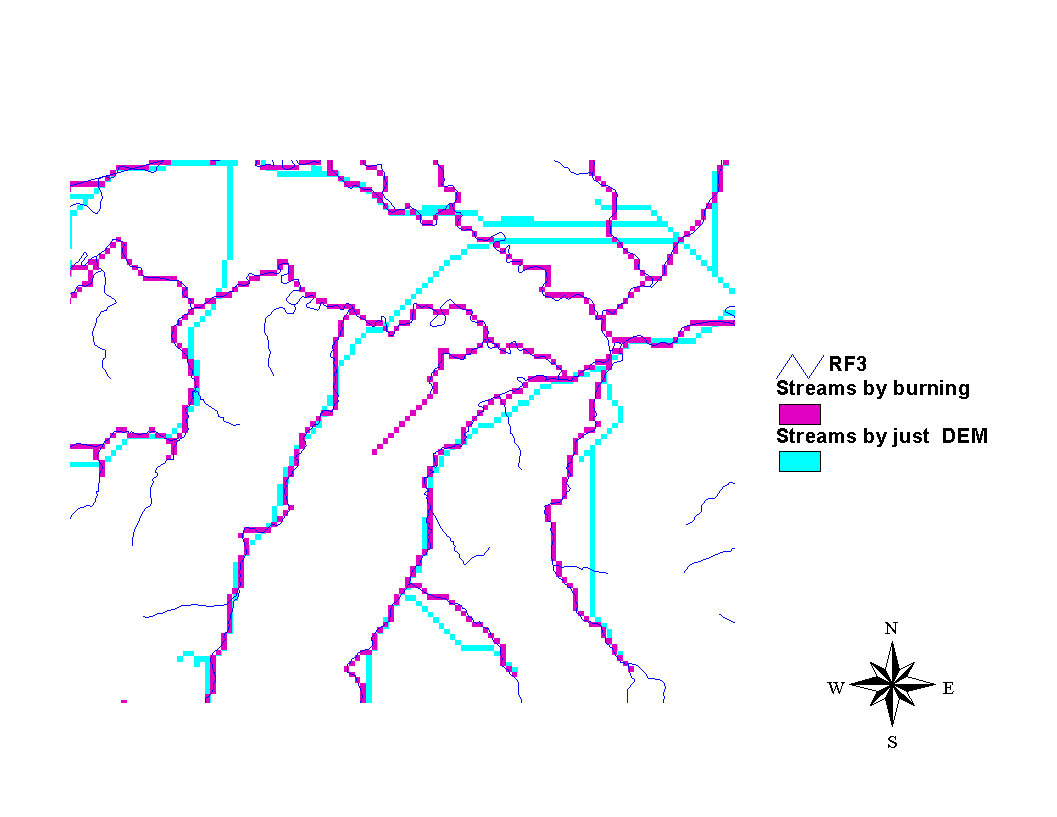
Both are applied to the original DEM before the application of the procedure described above. The first one allows to create flow networks across the landscape using both the line drawings of streams and the digital elevation to order the flows in downstream direction and to force the water to remain in the streams once reached. There are several option of this technique (Saunders, 1998), obtained raising, with a constant or spatially variable quantity, the elevation of all the cells but those that coincide with the digitized streams.
Figure 1 shows the visual result improvements of the application of this technique using the data described below in this paper.
Figure 1
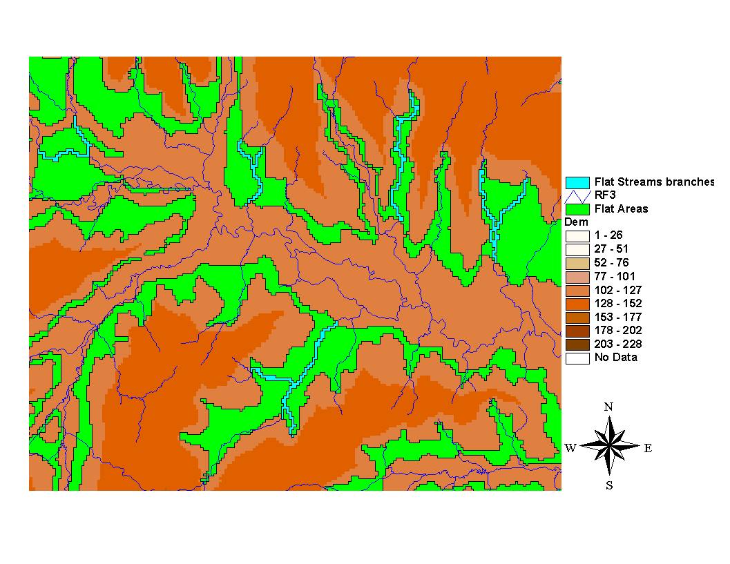
The second one is being developed and applied to detect and modify the DEM to produce realistic and topographically consistent drainage patterns. The problem (Garbrecht and Martz, 1997) arises with inadequate vertical DEM resolution and/or with discrete elevation resolution (integer values, either feet or meters) with the storage of same elevation data for large contiguous zones (flat areas) of the landscapes. A new applying approach consists in automatically locate the flat areas overlaying "critical" stream segments and replace the respective uniform elevation data with imposed gradient data.
Figure 2 shows an example of detected flat areas based on a previous detection of "critical" stream segments.
Figure 2
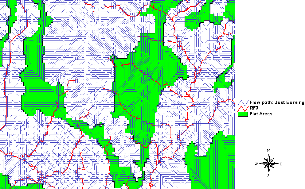
The zoom-in reported in figure 3 shows the flow direction lines as a result of the application of the standard procedure: the flat areas are characterized by a parallel flow direct line pattern.
Figure 3
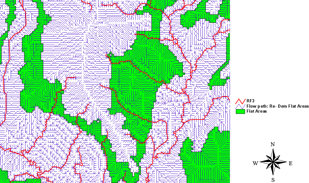
For the same zone, figure 4 shows the more realistic pattern of the flow direction lines with the previous modification of the DEM on the flat areas.
Figure 4
Data Sets
An undergoing project (TMDL analysis for the state of Texas) is being carried out for the TNRCC (Texas Natural Resource Commission, www.tnrcc.state.tx.us). One of the project tasks is to provide a digital data base (flow direction and flow accumulation grids) covering the entire area of the state of Texas for a quick definition of the drainage area at any section (outlet) located on the stream network. In order to proceed with the methodology described above, the following data sets have been set up:
1) Definition of the working data set boundaries: Texas territory has been split in 22 units based on a rough estimation of the main river watersheds and the remaining embedded coastal zones;
2) Considering the size of the study area (Texas area) and to ensure computation efficiency, the 3 arc second USGS DEMs (USGS, 1987), 1:250 000 scale map, covering the Texas area have been used (100 meters horizontal resolution in ArcInfo grid format);
3) USEPA Reach file 3 (RF3) data for Texas (ArcView shape format) has been set up.
RF3 (USEPA, 1994) is a river file system for the Nation that has been developed over the last 30 years by the EPA. RF3 is based on the 1:100,000-scale USGS digital line graph files and contains about 3 million stream segments organized by 8-digit USGS cataloging units and covers all the water bodies in the United States. RF3 uses a network format and, at every junction, the direction of the main stem of the river has been recorded. There are 40 attributes recorded for each stream segment. RF3 was developed to trace upstream and determine which segment drain to a point, or trace downstream and determine which stream segment will be passed through.
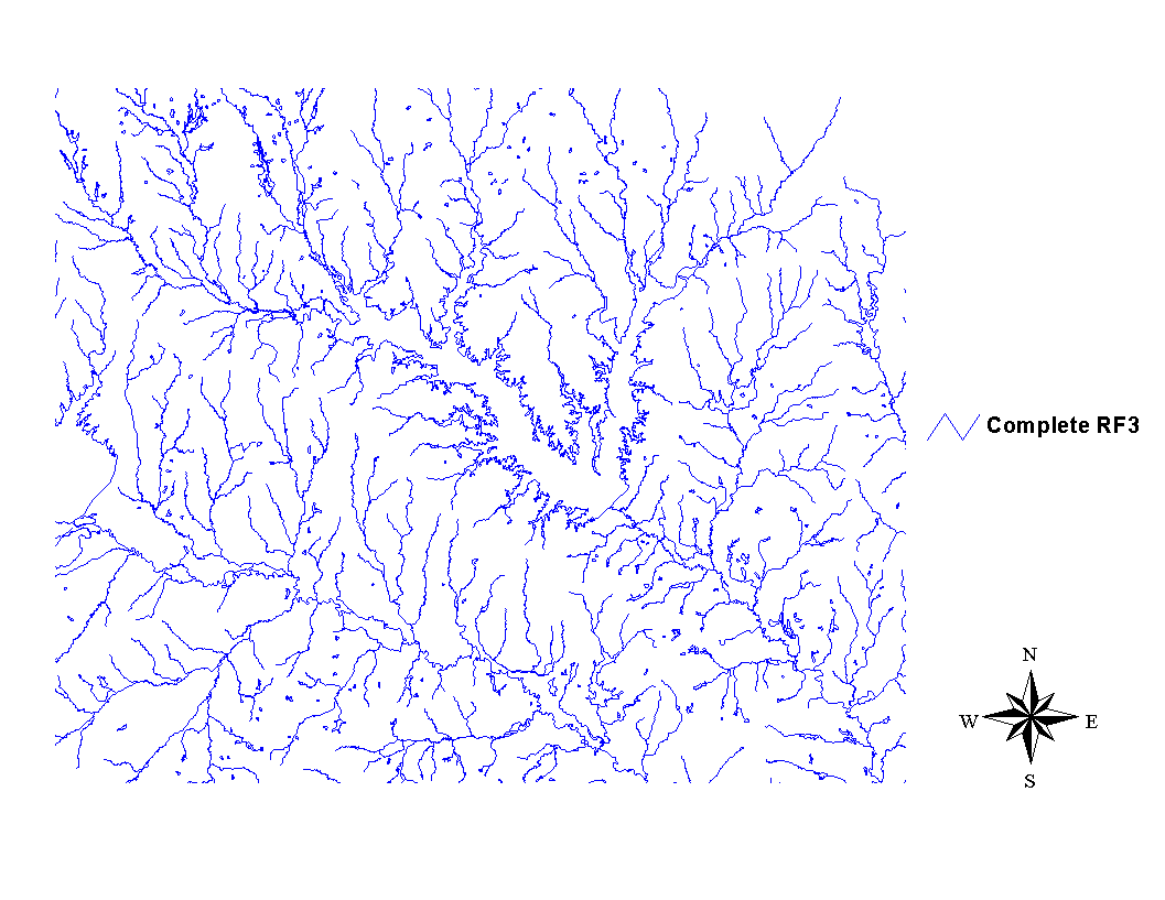
4) RF3 have been integrated with a centerline dataset, a component of the developing National Hydrography Dataset (Dewald and Roth, 1998). This data were generated using a raster-based, least-cost-path algorithm to compute the cheapest path through the wide river and lakes polygons. In order to successfully apply the DEM burning using RF3, the centerlines provides the linear stream connectivity lost by RF3 through reservoirs and wide rivers. Figure 5 shows an example of a complete original subset of RF3.
Figure 5
For this reason RF3 has been pre-processed in order to:
1) filter off the reaches representing no flowing water (shoreline, isolated stream reaches, ponds and wetlands):
The selection was operated with the following query to the RF3 table of attributes:
TheQuerrystring = "(([Reachtype]=""F"")or([Reachtype]=""R"") or ([Reachtype]=""S"")or([Reachtype]=""T"")or([Reachtype]=""X"") or ([Reachtype]=""Z""))"
Due to the occasional not consistency of the RF3 attributes, some of the deleted stream lines were re-integrated.
2) introduce the centerlines for lakes and wide rivers;
3) check and remove the eventually introduced breaks of the stream network continuity.
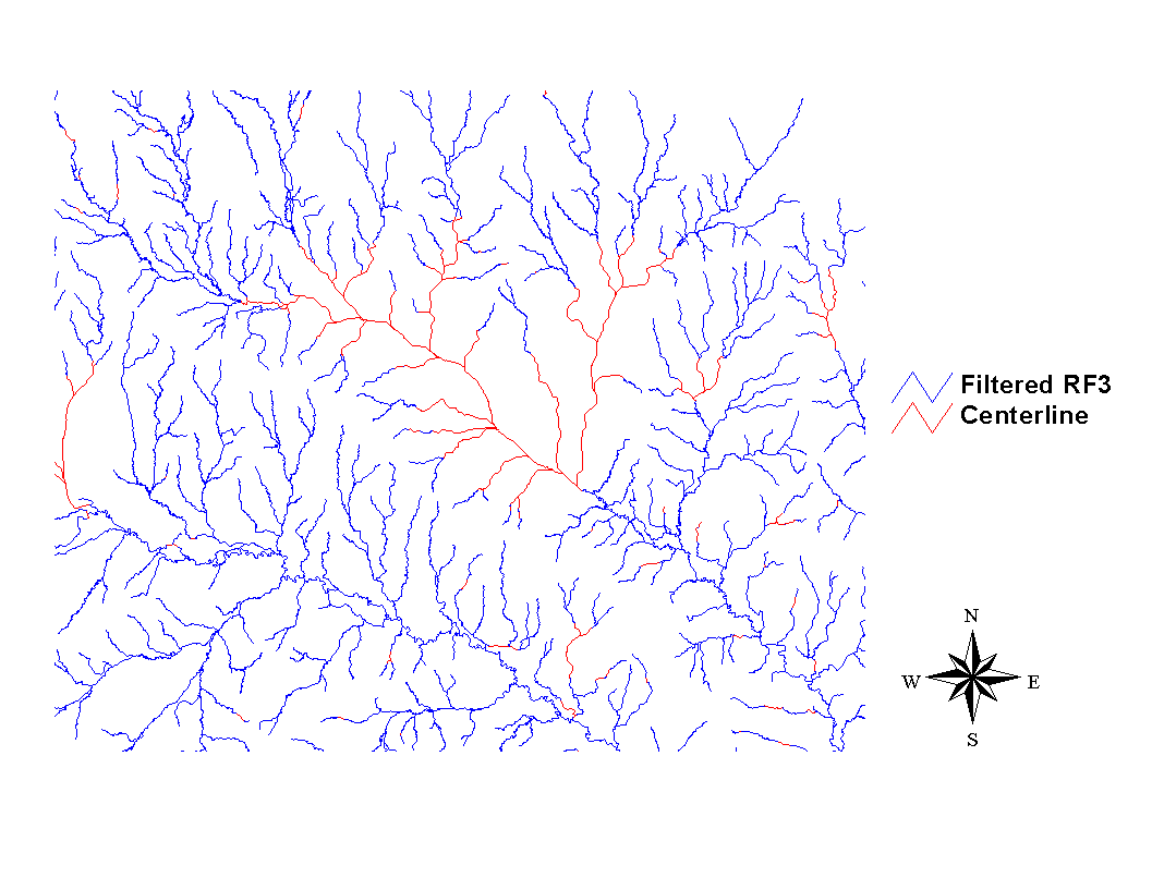
Figure 6 shows the RF3 data after the application of the filter and the checked integration of the centerlines data sets.
Figure 6
After these steps the network composed by the integration of RF3 and the centerlines were assumed to fully represent the Texas stream network characteristics.
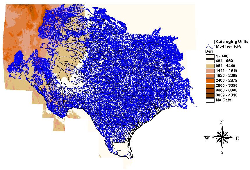
Figure 7 shows the entire DEM data set and the modified RF3 clipped on top.
Figure 7
Software implementation
ArcView and the Spatial Analyst extension provide a mixed grid vector environment ideal for hydrologic applications (Nelson et al. (1997), and Olivera and Maidment (1998)).
In this application the framework and tools provided by ArcView Hydrology Extension (Kopp, 1998) have been adapted and expanded using AVENUE, the object oriented ArcView's script macro language.
All the described procedures were implemented in the ArcView 3.1 Windows NT platform but due to the remarkable size of the data sets, some of the final processes are being operated in ArcInfo Unix platform.
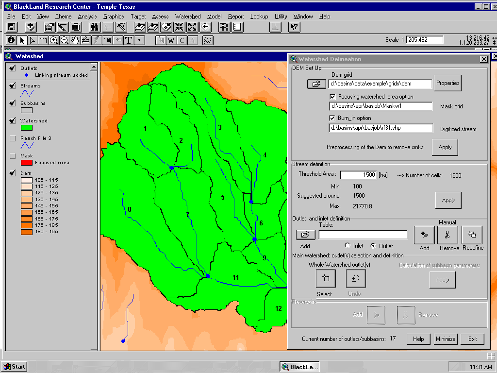
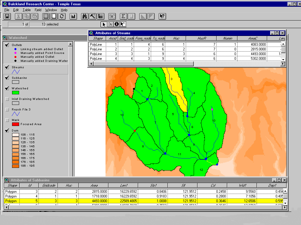
A further tool has been developed using another ArcView extension (Dialog Designer extension ver 3.1). The tool, upon the loading of the flow direction and flow accumulation grids in a View, provides an easy way to define the river network based on a user input flow accumulation threshold area, select target outlet points of the river network, delineate the resulting watershed boundaries and calculate the respective area. The tool is a reduced version of the watershed delineator developed at Blackland Research Center to integrate the SWAT model (Di Luzio et al., 1998). This is being further developed for the US.EPA as a component of an integrated tool framework to provide watershed assessments analysis of point and nonpoint sources (Battin, 1998).
Figures 8 and 9 show two snapshots of the watershed delineator being developed for US EPA.
Figure 8 and 9
Conclusions
The procedures of modification of the DEM within the flat areas and the stream lines zones are being applied using USGS 3 arc-sec DEMs and the modified RF3 for entire state of Texas. The software was implemented entirely using AVENUE and the hydrologic function provided in ArcView with the Spatial Analyst extension.
The preliminary visual results of the application of the described procedures show that the DEM-derived stream network resemble closely the one digitized and appears more realistic in zones with low gradient. Once the DEM will be processed the entire Texas digital database will be enriched of a flow direction and a flow accumulation grid that can be efficiently used by the set up tool or other software.
Focusing on watersheds with extension less the average main river watershed of Texas the use of this methodology and the already available higher resolution DEMs will probably overcome the problems connected with areas where the drainage splits or becomes a braided stream.
References
Band, L.E. Topographic partition of watersheds with Digital Elevation Models. Water Resources Research 22(1): 15-24, 1986.
Battin A. T. EPA's Better assessment Science Integrating Point and Nonpoint Sources (BASINS) - Integrated Analysis for Watershed Management. Preparation of DEMs for Use in Environmental Modeling Analysis. Proceedings of the same 1999 Esri International User Conference, San Diego, July 26-30, 1999.
Dewald, T.G. and K.S. Roth., 1998. The National Hydrography Dataset Esri 1998 User Conference, 1998.
www.Esri.com/library/userconf/proc98/proceed.HTM
Di Luzio, M., Srinivasan R. and J.G. Arnold. Watershed Oriented Non-point Pollution Assessment Tool. In Proceedings of the 7th International Conference on Computers in Agriculture. October 26-30, 1998. Orlando, Florida, 1998.
Garbrecht, J. and L. Martz The assignment of drainage direction over flat surfaces in raster digital elevation models. Journal of Hydrology, 193: 204-213,1997.
Jenson, S.K. Applications of hydrologic information automatically extracted from digital elevation models. Hydrological Processes, 5(1): 31-44, 1991.
Kopp, S. Developing a Hydrologic Extension for ArcView Spatial Analyst. ArcUser Magazine, April-June, 1998.
Moore, I.D., E.M. O'Loughlin and G.J. Burch. A Contour-based Topographic model for Hydrological and Ecological Application, Earth Surface Processes and Landforms, 13: 305-320, 1988
Moore, I.D., R.B. Grayson and A.R. Ladson. Digital Terrain Modelling : A Review of Hydrological, Geomorphological and Biological Applications, Hydrological Processes, .5(1): 3-30, 1991.
Nelson J., Jones N and Smemoe C. From a Grid or Coverage to a Hydrohraph: Unlocking Your GIS Data for Hydrologic Applications. Esri 1997 User Conference, 1997.
www.Esri.com/library/userconf/proc97/proceed.HTM
Olivera F. and Maidment D. HEC-PrePro An ArcView Preprocessor for HEC's Hydrologic Modeling System. Esri 1998 User Conference, 1998. www.Esri.com/library/userconf/proc98/proceed.HTM
O'Callaghan, J.F. and D.M. Mark. The Extraction of Drainage Networks From Digital Elevation Data, Computer Vision, Graphics and Image Processing, 28: 328-344, 1984.
O'Loughlin, E.M. Prediction of Surface Saturation Zones in Natural Catchments by Topographic Analysis, Water Resources Research, 22(5): 794-804, 1986.
Maidment D.R. Geographic Information Systems and hydrologic modeling, Proceedings of the "Scientific assessment and strategy team workshop on hydrology, ecology, and hydraulics: Sioux Falls, South Dakota, February 15-16, 1994.
Saunders W. Preparation of DEMs for Use in Environmental Modeling Analysis. Proceedings of the same 1999 Esri International User Conference, San Diego, July 26-30, 1999.
US. Environmental Protection Agency. The US. EPA Reach File Version 3.0. Alpha Release (RF3, Alpha). Technical Reference. First Edition December 1994. www.epa.gov/owowwtr1/NPS/rf/techref.html
US. Geological Survey. Digital elevation model - Data users' guide: Reston, Va., U.S. Geological Survey, 1987.
Vieux, B.E. Geographic Information Systems and Non-Point Source Water Quality and Quantity Modelling. Hydrological Processes, vol.5, no.1, pp. 101-113, 1991.
Mauro Di Luzio
Post. Doc. Research Associate
TAES, Blackland Research Center
808 E. Blackland Rd
Temple, TX 76502
Telephone: (254) 770-6622
Fax: (254) 770-6690
E-Mail: diluzio@brc.tamus.edu
Raghavan Srinivasan
Associate Professor
TAES, Blackland Research Center
808 E. Blackland Rd
Temple, TX 76502
Telephone: (254) 770-6670
Fax: (254) 770-6561
E-Mail: srin@brc.tamus.edu