
MOUNTAIN HOUSE NEW TOWN GIS – From the Ground UP
By: Erin T. Mutch, Ronald L. Skaggs
Abstract:
Mountain House is the first new town chartered by the State of California in the past forty years. The total area is 4,784 acres and the Mountain House Community is located in the Central Valley between Stockton and the San Francisco Bay Area. On complete build-out the town will incorporate almost 5,000 acres and be home to more than 40,000 residents.
In 1997, Trimark began to develop a community-wide GIS began for what is believed to be one of the first GIS for a "greenfields town". Services from several consultants, including engineering, earth sciences and mapping produced data that is utilized in a GIS.
GIS is currently being used for general planning, geologic characterization, management of utilities, watershed analysis, transportation cost estimates, and marketing. In the future, the Mountain House Town Community Services District will utilize the extensive GIS database for monitoring and maintenance of activities associated with public services.
Introduction:
In 1997, a GIS was initiated for what is believed to be the first GIS for a completely "greenfields town" located in the Central Valley between Stockton and the San Francisco Bay Area. The project site has historically been used for field and row crop agriculture with a smaller area in non-irrigated pasture and irrigated and non-irrigated cropland. The GIS is being designed to accommodate twelve neighborhoods, each organized around a Neighborhood Center containing a park, a K-8 school, and a small commercial area. The neighborhoods will each have a separate identity, achieved through unique design and landscaping. Major shopping and other services will be met by the Village Centers and the Town Center, the civic and commercial focus of the community is designated for mixed commercial, office, and residential development. Employment centers will include office and industrial parks. Golf courses and a full marina on Old River are also planned during the anticipated twenty-year build-out of the town, which will be home to more than 40,000 residents.
The GIS was created from CAD files, previous survey information, and other environmental and geological field data collected using PenMapÒ. In a span of fifteen months, we created over two hundred GIS layers for various purposes. The developed layers currently being used for general site planning, hydrologic analysis, utilities planning, and project marketing. A major function of the GIS is to provide information to the existing San Joaquin County GIS to help insure consistency in long-term planning and coordination for the project. In addition, the Mountain House Town Community Services District can use the extensive GIS database for future planning.
GIS Utilization and Applications
Existing conditions and constraints
GIS services were provided such as GIS analysis and querying to Trimark Communities as it pertains to the Master Plan and Specific Plan maps. The GIS was used for map production services, in which the maps are used in documentation and for marketing meetings. Another use of the GIS for the preparation of the Master Plan and Specific Plan are queries and calculations. In order to meet plan requirements, the GIS is used to verify acreage of proposed land use, and to also provide maps and edited digital information to San Joaquin County.

Figure 2: Mountain House Community Specific Plan
As the master and specific plans were more fully developed, storm-water systems were developed to accommodate surface runoff. Existing soils, proposed land use, and watershed boundaries were used in an overlay analysis to automate run-off calculations. ARC/INFOÒ and AML programming language quickly calculated results, and provided significant time savings as compared to traditional calculations. This analysis was used for both the Master Plan and the Specific Plan watershed development. The GIS model accommodated over thirty watershed changes, and significant time savings were realized almost immediately.
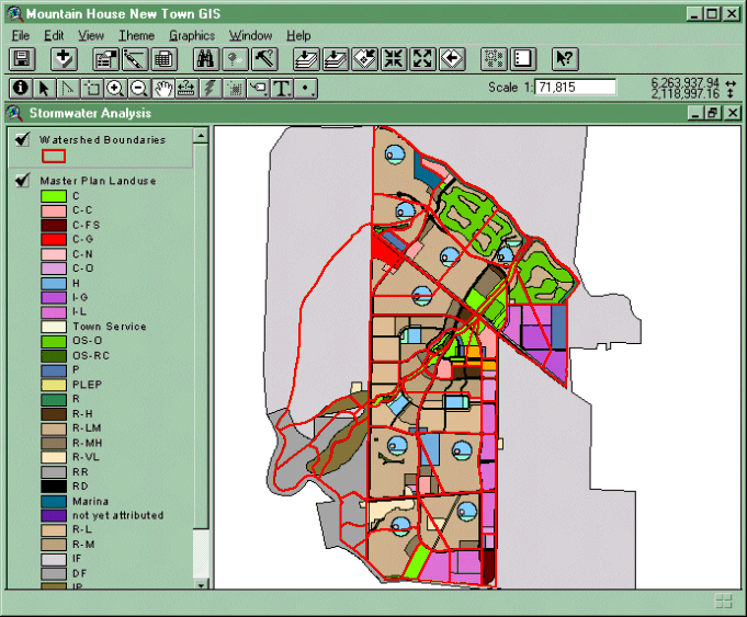
Figure 3: Master Plan and Watershed Boundaries
A detailed cost estimate for future roadway construction for the entire Mountain House community was required to determine impact fees. The estimate was based on proposed roadway right-of-ways that depicted arterials and major collectors. Proposed roadway cross sections depicting landscaping, curb and gutter, sidewalk, median and pavement widths were used to generate polygons. Calculations for earthwork costs were also included in the model, which were based on volumetric calculations. All polygons were attributed with a unique code, road name, location information and traffic index values in order to calculate costs, and to export into specific tables. Over 800 polygons were created, and AML programming was used to calculate the costs, and export into ninety different spreadsheets for specific results. Sound walls, agricultural fences, entry signage, traffic signals, and streetlights were calculated using GIS features. This system allows for spatial and tabular changes and updates, so that the end user can also evaluate the results graphically and determine if current or future changes are needed. Specific queries and clip analyses are also used to analyze a specific area or feature cost.

Figure 4: Transportation GIS
Constraints and Challenges
The process of creating a GIS from data that does not yet ‘geographically exist’ poses many challenges. Many of these data are used for planning purposes, and are subject to many changes. Management and documentation of these changes is difficult due to the dynamic nature of the data. Another constraint of the constant changes is providing the most current information to the project team. In many situationss the data is used for many purposes, using either CAD or GIS, and it is important to make sure all data is consistent for map output.
Another challenge in implementing a new GIS is getting new information into the GIS. It is importatnt to carefully decide which new data is worth the effort to bring into the GIS, and what the end use of these data will be. It has been learned in this process that not all data should be brought into to the GIS unless it will be used for a beneficial purpose such as analysis, map production, or future infrastructure management..
Future vision
The comprehensiveness of the GIS library and its use by engineers, planners, surveyors and decision-makers that can utilize the GIS library is driving the need for an internet map server. We plans to use ArcIMS to allow multiple parties to visualize, query, analyze, edit, and request hard copy maps. This approach will allow for maximum utilization of the GIS, and immediate viewing as the GIS is updated. The internet users will be able to verify if information is correct, and request digital files by using this system.
Conclusion
Many benefits have resulted in the GIS implementation for theMountain House New Community, and many lessons have been learned during the process. Proper maintenance of the GIS and the ability to fully utilize the information will be the key to the future success of the GIS.
Acknowledgements
The following individuals are gratefully acknowledged for their contribution to the sucessful development of the Mountain House GIS.
Mr. Duane Grimsman – Sterling Pacific Assets
Mr. Eric Teed-Bose – Trimark Communites
Mr. Ron Gross – Trimark Communities
Ms. Trish Mobley – Trimark Communities
Mr. Jim Leonard – Mountain House Community Services District
San Joaquin County Department of Planning
USGS – Bay Area Regional Database
Mr. Lynn Sutton – Sutton Engineering
Mr. Kenneth Tappin – Carlson, Barbee and Gibson
Mr. Larry Patterson – Optrans
Mr. Barry Hillman - Condor Earth Technologies, Inc.
Mr. Gio Del Papa – Condor Earth Technologies, Inc.
Mr. Larry Coughran – Condor Earth Technologies, Inc.
Mr. Doug Polzoni – Condor Earth Technologies, Inc.
Author information
Erin T. Mutch
GIS Administrator
Condor Earth Technologies, Inc.
PO Box 3905
21663 Brian Lane
Sonora, CA 95370
209.532.0361 209.532.0773 (fax)
emutch@condorearth.com
Ronald L. Skaggs
Division Manager
Condor Earth Technologies, Inc.
188 Frank West Circle Suite I
Stockton, CA 95206
rskaggs@condorstockton.com
209.234.0518 209.234.0538 (fax)
For information on Mountain House New Community - go to - www.mountain-house.com
For information on Condor Earth Technolgies, Inc. go to - www.condorearth.com