Improving Environmental
Assessment and Management Through a GIS-Enabled Expert System Approach
Philip Bailey
Environmental impact studies
are costly and time-consuming and involve the collection, review and analysis
of large volumes of information by experts. Conventional EIS/EIR approaches
do not typically integrate information and knowledge in a practically applicable
form. A Unique, ArcView GIS-enabled expert system is being used by land
managers, natural resource managers and project developers to address this
shortcoming. The system captures multidisciplinary expert knowledge, comprehensively
predicts impacts, documents each analysis, pinpoints information deficiencies,
rapidly facilitates "what if" evaluation of alternatives, recommends mitigation
and monitoring actions, and creates a range of text and map-based reports.
Once a given assessment is complete, the system is ready for use as an
in-house environmental management decision support system.
Introduction
The field of environmental planning and management
has been the focus of many technological developments. Proposed solutions
have been varied and typically focused towards a single application or
sector, such as facilities management. There remains, however, several
key environmental management challenges that are not comprehensively addressed
by the diverse range of customised solutions;
-
Timely access to multidisciplinary knowledge
-
Information access and overload
-
Reliance on subjective judgment
-
Capturing and taking advantage of "institutional
wisdom"
-
Facilitating cost-effective "what-if" alternatives
analyses
-
Creating a defensible, transparent record
of analysis
-
Making sure important issues are proactively
identified
Nobility Environmental
Software Systems Inc. have targeted over ten years of research and
development at these challenges in an attempt to produce a general purpose
environmental planning and management software product. The result of this
effort is Nobility EM,
a GIS-enabled expert system. This paper outlines the Nobility
EM solution, provides two brief application
examples and summarises the benefits of this approach to environmental
planning and decision support.
Nobility EM - A GIS-Enabled Expert
System
Expert systems employ a series of rules to
solve a particular problem. In the case of Nobility
EM, the problem is environmental and the solution is a management or
planning strategy (Figure 1 and 3). The rules, or environmental knowledge
are processed by an inference engine, the core of the system. The inference
engine is responsible for determining the relevant issues, or environmental
impacts.
The environmental management problem is
divided into two parts. First, an Environmental Description describes
the environmental setting where the problem is located. Second, intended
Activities
are defined which are intended a part of a proposed Project.
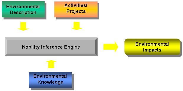
Figure 1 The
Nobility EM Expert System
The environmental knowledge is stored in the
Knowledge
Base and contains rules describing which activities cause environmental
impacts on the components making up the environmental description. Rules
are represented as two types of environmental impacts (Figure 2);
-
Primary Impacts representing the effect of
an activity on a component (e.g. Fire damages or destroys Vegetation).
-
Secondary Impacts representing the effect
of an impacted component of another component (e.g. Damaged Vegetation
causes Soil Erosion).
A knowledge base will typically consist of
thousands of impact rules. Each rule is dependent on a set of conditions
occurring. For example, for the Inference Engine to determine that Fire
does
in fact impact Vegetation it might depend on whether a fire is within
50m of the vegetation, or whether rainfall has occurred recently, or whether
dead vegetation material has been cleared.

Figure 2 Environmental
Impact Structure
GIS Data and Environmental Knowledge
Frequently, attempts to develop environmental
management tools have been non-spatial, despite the inherently spatial
nature of many of the issues involved. Nobility
EM is a spatially aware system, and as an ArcView
extension, it incorporates all of the power of Esri's
popular desktop GIS.
Spatial data is used to represent the environmental
components and to identify the location of project activities (Figure 3).
This spatial data is tightly linked to attribute information stored in
a database together with the environmental knowledge. The solution is presented
to the user as a series of formatted reports and digital maps, customisable
for the users' specific application.

Figure 3 The
Nobility EM Expert System Architecture. Adapted from Merritt, D. (1989).
Example 1: Quarry Construction
Figure 4 illustrates the simplicity of generating
environmental impacts using Nobility
EM. The user has drawn the location of a proposed quarry. This shapefile
is displayed within ArcView, together with a background satellite image,
other shapefiles have been attached to environmental components (such as
animal habitats and nesting areas), but are not displayed.
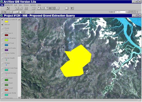
Figure 4 The
Location of Proposed Quarry Construction.
With a single mouse click, the Nobility
EM Inference Engine interrogates the environmental knowledge and returns
a list of impacts generated by the activity type Quarry Construction.
The impacts are displayed in an Explorer, organised in a variety of ways,
in this case, by environmental issue (Figure 5).
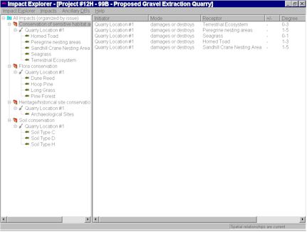
Figure 5 Quarry
Construction Environmental Impacts.
In addition to the Impact Explorer, Nobility
EM provides a spatial view of the environmental impacts using ArcView.
Figure 6, demonstrates how the proximity of the proposed quarry construction
to sensitive environmental components determines the degree of impact.
The strongest impacts, indicated by the darkest shades of red, are closest
to the quarry location with the impact decreasing outwards from the proposed
activity.
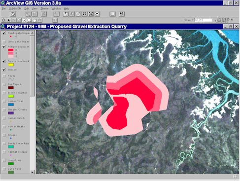
Figure 6 Spatial
Display of Quarry Construction Environmental Impacts.

Figure 7 Example
Reports Produced by Nobility EM.
Example 2: Airport Regulation Compliance
Nobility
EM is an attractive technology to enforce regulation compliance. Table
1 outlines a simple example of regulations controlling subdivision development
around an airport. Nobility
EM was used to capture this information and represent it as a series
of environmental impact rules based on the location of the Activity
SubDivision Development near to a series of environmental components representing
an airport infrastructure.
Table 1. Airport Compliance Regulations
| Impact Degree |
Description |
| 5 |
Construction is not permitted in the proposed location |
| 4 |
Construction of buildings shall conform to the exterior acoustic insulation
requirements |
| 3 |
The development shall be covered completely |
| 2 |
The development shall not include structures for the seating of spectators |
| 1 |
Construction is permitted with no conditions |
The environmental impact rule is based
on a number of conditions. Each set of conditions is referred to as a Case,
and typically has a different impact degree.
Table 2 demonstrates how the noise contours
determine the degree of impact. The Spatial Relationship refers to the
spatial proximity of the subdivision development to the airport. The Development
Type in this example is Residential and does not change between
cases. The Noise Intensity refers to the volume of aircraft taking movement,
and is dictated by the proximity to the airport. In this example noise
contours have been digitised and are represented as environmental components
(Figure 8).
Table 2. Airport Compliance Rules
| Rule Property |
Case 1 |
Case 2 |
Case 3 |
Case 4 |
| Spatial Relationship |
on/in |
on/in |
on/in |
on/in |
| Development Type |
residential |
residential |
residential |
residential |
| Noise Intensity |
40+ |
35-40 |
30-35 |
25-30 |
| Impact Degree |
5 |
4 |
3 |
2 |
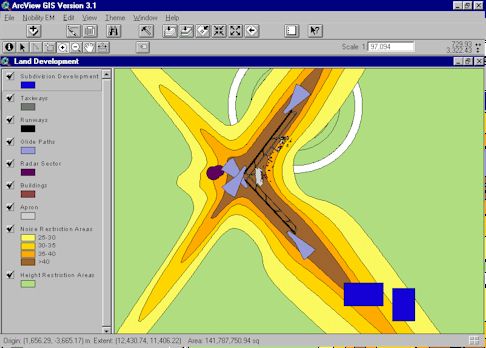
Figure 8 The
Location of Subdivision Development near an airport.
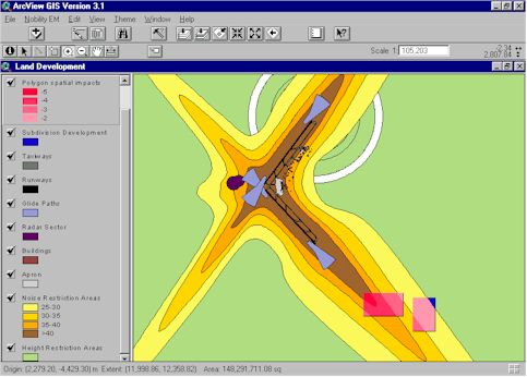
Figure 9 Spatial
Display of Impacts Caused by Subdivision Development near an
Airport.
Nobility EM Applications
-
Environmental impact assessment
-
Environmental inventory
-
Environmental compliance reporting
-
Land management
-
Construction and maintenance
-
Best Management Practices (BMPs)
-
Alternatives analyses
Nobility EM Benefits
-
Ensures assessment quality, structure and
consistency for more defensible decision making
-
Saves time - identifies impacts in minutes
-
Brings information and multidisciplinary knowledge
to a wider range of users
-
Facilitates rapid, comprehensive analyses
of alternatives
-
Helps avoid costs and concerns resulting from
unforeseen impacts
-
Retains project histories / knowledge / information
to avoid "reinventing the wheel" and to guide future decisions
Conclusions
There are several key challenges not addressed
by existing environmental planning and management technologies. Nobility
has developed a GIS-enabled expert system that addresses these challenges
and represents a quick and easy way to identify and report environmental
impacts. This technology can be used for a wide variety of applications,
two of which are briefly described.
References
Merritt, D. (1989) Building Expert Systems
in Prolog, Springer-Verlag, New York.
Acknowledgments
Thank you to the Heather Alexander, Monique
Cornish, George Davis and Dennis Radage of Nobility for their advice and
comments during the preparation of this paper. The screen shots for the
airport application example were prepared by Heather Alexander.
Contact Information
Philip Bailey
Software Development Engineer
Nobility Environmental
Software Systems Inc.
Suite 300 1765 West 8th Avenue
Vancouver BC V5Y 1S3
Canada
pbailey@nobility.com
Tel: (604) 733-2996
Fax: (604) 733-4657