Texas A&M University-Corpus Christi students utilized Adopt-A-Wetland text data and ArcView GIS software to create a Texas wetlands regional GIS, supporting the location of specific wetland sites and their species. The Adopt-A-Wetlands Program works with Texas public schools whose classrooms "adopt" a wetland site, then monitor, gather, and record flora, fauna, and water quality data. The project incorporates the use of GIS into K-12 volunteer environmental monitoring and data gathering projects. This gives their data a spatial aspect, allowing for analysis and providing a better understanding of their world and what they find in it.
Combining the energy of school children, the diversity of environmental data and the power of Arcview - Geographic Information Systems (GIS) has led to the beginning of a rewarding relationship. The children gain great insight to their world by gathering environmental data, creating hi-tech maps and other products which encourage thinking and analysis. This identifies just a few benefits and rewards gained by incorprating geographic information technology into elementary and secondary school curriculums.
The teachers of Texas have an excellent opportunity to foster a powerful relationship in their classrooms, through the Adopt-A-Wetlands Program (AAWP) and use of geographic information technology. The AAWP is administered by the Center for Coastal Studies at Texas A&M University - Corpus Christi (TAMUCC), and is located on the campus. The AAWP provides workshops for elementary and secondary school teachers, providing them with classroom activities and curriculum materials. The program assists teachers in the development of a wetlands monitoring site for their classroom by teaching sampling techniques, wetlands flora and fauna identification and water quality monitoring skills. The hands on training provided to the teachers and taken into the classroom serves to "promote wetlands conservation through education".
Once the teacher and students have adopted a wetlands site, data collection and analysis begin as classroom activities. As it currently stands the mapping and subsequent analysis are done on paper. Maps of wetlands vegetation and charts of related plant and marine life are done on paper with colored pencils and markers. Our project serves to incorporate the use of Arcview GIS to the wetlands monitoring activities in the classroom. We will serve as a type of database/project manager for the teachers and students. We will provide base layer data to the class that will include a digital United States Geological Survey quad sheet (USGS - DOQ) and a satellite image. One of our first activities will be to take the class out and survey the adopted wetlands site with global positioning equipment, obtaining accurate coordinates. From there, additional layers of data are developed by the teacher and students as they do field visits and gather environmental data about their adopted wetlands site.
We decided to import an external database into ArcView to have the functionality of a relational database.The Microsoft Access database was chosen because it is already used by most schools. Microsoft Access also has an intuitive user interface that makes the software easy to learn and use. Also, Arcview's SQL Connect feature, makes a simple process out of the critical task of importing tables into ArcView.
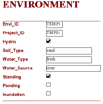
Seven tables make up the Microsoft Access database. The tables describe plant, animal and environmental data within a project area. The tables are incorporated into the GIS project to link wetland sites to specific regions on the map.

The relationship between related tables is one to many. For example, there can be many projects sites within one region or one project site can have many animals. Once the tables are imported into ArcView using ArcView's SQL connect feature, the tables can be joined together. The resulting table can use all of ArcView's features.
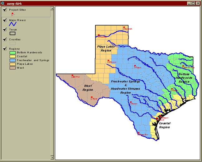
The Adopt-A-Wetland project continues to grow within ArcView itself. Many innovations have been made and progress continues to give the project integrity. The project has a view of Texas which has distinct wetlands regions and project sites, all of which have flora and fauna characteristics, as well as geographic location. Upon identifying project sites in Arcview, a list of information is given, such as project site name, size/area of the site and site latitude and longitude coordinates. Queries are possible by connecting Microsoft Access tables to ArcView. These tables are imported using the Database Access extension in ArcView 3.1, where a *.mdb file is located and connected using the SQL Connect option.
The project's Microsoft Access database is currently structured for flora, fauna, environmental, and location data. However, teachers and students have the freedom to change or customize their database. An enhancement that seems attractive to the AAWP staff is publishing it on the internet. This is possible with ArcView's Internet Map Server extension, which is available for this project. The project is placed on a parent server and viewed by school children and other interested parties by downloading ArcExplorer 1.1. This is the most effective and economical use for public schools, as they aren't required to have Arcview installed on every PC. Another future enhancement would be to create cgi scripts and an electronic form, allowing project data to be updated at Texas A&M University - Corpus Christi campus via the internet. It is a future project priority to enpower students by enabling them to access the project, update the data and even create new sites. Another project item in development is to hot link OLE images to the data tables. The images would include specific flora and fauna, pictures of the project sites, as well as pictures of the teachers and students on location. Dedicated students at Texas A&M University - Corpus Christi are continuing on with the project. Ultimately, we hope the project will help teachers, K-12 and even college students learn about GIS, environment science, computer technology and the power of teamwork. A by-product of this project, is a wetlands information resource for scientists, conservationists and anyone who would like to learn, understand and protect these areas for the benefit and use by future generations.
This is an ongoing project with great potential . We have initiated a relationship with a 6th grade teacher, visited their adopted wetlands site and reviewed the paper maps drawn by the students. The proposed next phase of this project is to develop and implement a GIS component to the classroom's wetlands monitoring activities. Some elements of the next phase in this project include, educating the teacher about Arcview and developing scheduled classroom visits with set objectives.