Transferring GIS Technology to Watershed Planning Groups in the Field
ABSTRACT:
The NRCS California Watershed Planning Services staff, along with the NRCS Watershed Science Institute, is working to develop and transfer GIS technology to watershed planning groups in the field. Local land managers and watershed stake holders are becoming more interested in using GIS technology to assist them in consensus based watershed planning, management and research. Our goal is to help these groups develop the GIS capabilities they need so that members of the watershed group can use it. ArcView GIS for PC is an easy way for them to learn to work with available data, remote sensing imagery and to use GPS to create new data layers.
Section 1: History of Watershed Planning Services
As a Government agency, the Natural Resources Conservation Service (formerly known as the Soil Conservation Service), has traditionally had the responsibility for creating and maintaining both paper and digital soil survey maps. But as our name change reflects, we are now focusing on more natural resources than just soils. The Watershed Planning Services staff of the NRCS California State Office in Davis is evolving from implementing specific federal watershed programs to supporting field staff with a variety of shorter-term watershed projects. In this evolution GIS has become an important part of the work. GIS support, at this initial stage, ranges from assiting our field offices and their clients in using online interactive mapping such as ICEMaps, to guiding our field offices and their clients in the development of desktop GIS using ArcView or ArcInfo.
What is a Watershed?
The "watershed" is the unit of landscape, and framework around which, to think together about the land and its role in peoples' lives. It provides the perspective of how people and natural systems interrelate to affect the landscape as a whole and provides a basis for evaluating progress towards achieving conservation objectives established by the community. (From America's Private Lands: A Geography of Hope, USDA, Natural Resources Conservation Service, June 1997)
The mission of Watershed Planning Services is to assist decision-makers in identifying and evaluating the impacts of their decisions at the watershed level. Working in interdisciplinary and interagency teams we:
- provide written reports and plans
- provide technical consultation
- provide training and education
- develop data and information systems
- analyze resource problems and opportunities
- identify and evaluate alternative solutions.
Our goal is to facilitate the use of GIS in watershed decision-making. We work to develop and transfer GIS technology to watershed planning groups in the field by helping them to identify the most appropriate “type” of GIS for their needs:
- online interactive mapping (ICEMaps)
- simple desktop (MapInfo, Atlas)
- intermediate desktop (ArcView)
- full GIS system (ARC/INFO)
Section 2: Specific Work Products
The following examples demonstrate the range of GIS support WPS provides to the field. The examples progress from the simplest response, through the more complex, depending upon the needs of each group.
Upper Putah Creek Watershed:
This local request came from a Watershed Group that has not yet used GIS. They are very interested in developing and maintaining a GIS for their watershed project in the future, although are not quite ready to make the commitment at this time. We referred them to the online interactive "ICEMaps" from U.C. Davis, to create and print maps of their watershed. With ICEMaps they can create land use, vegetation and other maps off the web, and print them for reports and presentations.
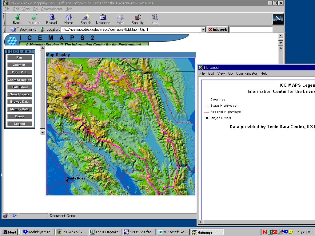 click for enlargement, ICEMap of Upper Putah Creek Watershed.
Shasta County Watersheds:
The Redding field office requested a map of all the watersheds in the county. We used ArcView to create the map they wanted from existing statewide data, creating new shapefiles for their watersheds. The watershed boundaries are based on the CalWater "super watershed planning unit" polygons, and were pieced together from the existing polygons to create watershed outlines the local land managers would recognize by name.
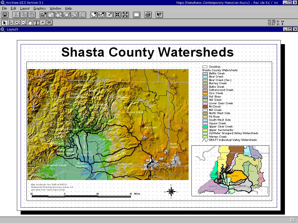 click for enlargement, Shasta County Watershed Map.
The Concord field office requested we assist the co-located Contra Costa Resource Conservation District (CCRCD) in developing an ArcView database for their watershed. The challenge was to combine existing data with new data, to work with data of different scales, and to handle difficult issues such as differing map projections and datums, data compatibility and import problems. We assisted them in acquiring DEM and DOQ data from the USGS. With outside grants, the CCRCD purchased existing data, such as Teale county-wide data and SureMaps Raster Graphics. We also assisted them in collecting and creating new data based on GPS points and field observations, and in entering metadata in the CERES Information Catalog. Using the DOQs as a basemap, they now have the capability to edit and improve their data, such as a statewide vegetation map updated with more detail for use at the local level.
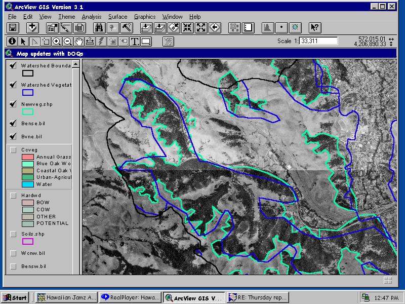 click for enlargement, Alhambra vegetation update based on DOQ.
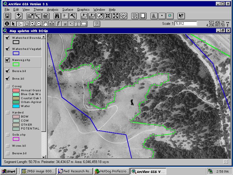 click for enlargement, Zoom in on the editing process.
Through a partnership with the NRCS Watershed Science Institute, and a grant from The Nature Conservancy Conservation Research Program, we are working with local land managers in Hawaii to develop new technologies, and then to transfer these technologies to others in the field through a series of "Technical Notes." This project used remote sensing with GPS ground verification of vegetation to locate alien plant species Micona (miconia calvescens). The goal was to identify unique spectral signatures for Miconia, and surrounding plants, and then use the signatures to identify that same signature in a remote sensing image. This should allow the verification of known stands, as well as new, unknown stands, in the remote sensing imagery to assist in removal and eradication of Miconia.
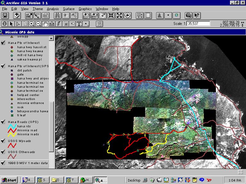 click for enlargement, Aerial imagery with GPS ground points.
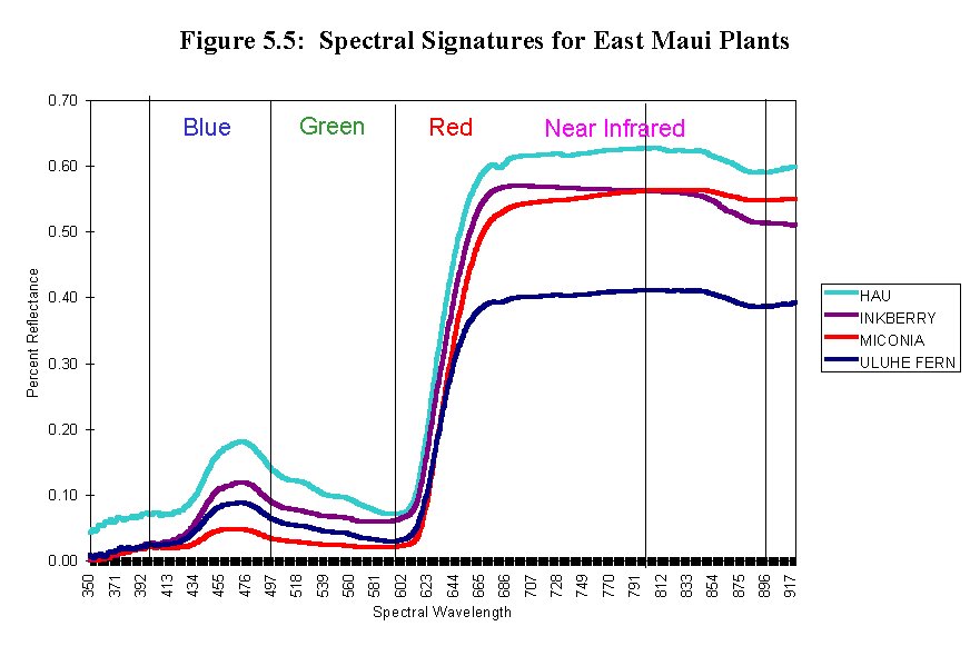 click for enlargement, Spectral signatures for Hawaiian plants, including Miconia.
C-RORGEN:
The Community Rate of Return Generator (C-RORGEN) will use GIS information and data processing to estimate the costs and benefits of fuel load reduction practices for preventing catastrophic wildfires. This is being developed for the Cold Creek Watershed where we are gathering institutional and technical information about the structure of costs:
- slope effects
- vegetation type and density effects
- sensitive soils effects
- vegetation removal rules
- distance from roads
The cost estimator part of C-RORGEN is currently under development and involves writing Avenue scripts emphasizing GRID analysis. The cost estimator will be a stand-alone ArcView Extension which will hold the all of the data and customized tools local people will need to estimate the costs of treating areas they choose. Of primary importance in this project is the concern about error propagation, due to the use of at least 5 data layers in the cost estimator. The cost estimator will be available for local people before the benefit estimator is created. The idea is to provide an interactive tool that is user friendly for community meetings, and will answer community questions such as:
- Why are the costs so high?
- What are the benefits, really?
Section 3: The Future
The future of GIS in NRCS will continue to focus on the development of digital soil surveys and information. But to assist our field offices in the delivery of better conservation practices and planning too to local land managers, the NRCS is implementing a Common Computing Environment and a Customer Took Kit. This will include ArcView and DOQs for use on laptop computers in the field, as well as office desktop computers. The goal is to bring GIS-based information to local land managers where and when they need it. The future of GIS in Watershed Planning Services is continued support to the field with increasing interdisciplinary GIS modeling work.
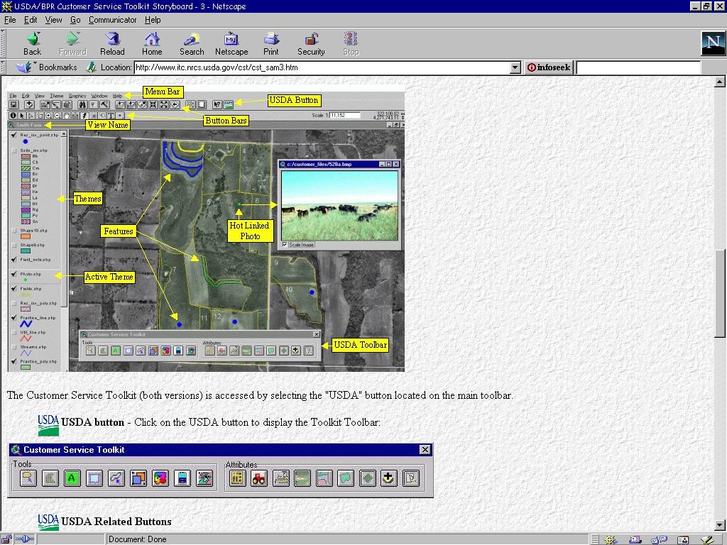 click for enlargement, Screen caputre of the Customer Tool Kit being developed by NRCS.
But the NRCS Watershed Planning Services staff in Davis, California, is also looking for opportunities to partner, share experiences and approaches, as well as data. We're looking for:
- Avenue script writing buddies, especially GRID analysis functions
- Partners with local NRCS field offices and local Resource Conservation Districts
- Successful innovations in Watershed Analysis using ArcView and extensions
If you would like to learn more about any of these projects, we encourage you to explore the web-links imbedded in this paper, or to contact us via email. Working together, we can bring GIS technology to watershed planning groups in the field, where it is needed most.
Dr. Robyn Lee Myers, Primary Author
State Landscape Ecologist, Watershed Planning Services
USDA Natural Resources Conservation Service, Davis, CA
robyn.myers@ca.usda.gov
Dr. Madalene M. Ransom, Co-Author and Presenter
State Economist, Watershed Planning Services
USDA Natural Resources Conservation Service, Davis, CA
madalene.ransom@ca.usda.gov
430 G Street, #4164
Davis, CA 95616
Voice: (530) 792-5666
Fax: (530) 792-5794
 click for enlargement, ICEMap of Upper Putah Creek Watershed.
 click for enlargement, ICEMap of Upper Putah Creek Watershed.
 click for enlargement, Shasta County Watershed Map.
 click for enlargement, Alhambra vegetation update based on DOQ.
 click for enlargement, Zoom in on the editing process.
 click for enlargement, Aerial imagery with GPS ground points.
 click for enlargement, Spectral signatures for Hawaiian plants, including Miconia.
 click for enlargement, Screen caputre of the Customer Tool Kit being developed by NRCS.