Today HT uses GIS tools on various levels in order to make strategic analysis in preliminary planning phases, for the detailed scheduling and for registration of the single bus stop.
HT uses GIS tools in traffic planning as a scheduling and decisive tool. The background of this is that HT for the last 12 years has been working with securing and improving the automatic passenger counting system, PTS, which is an electronic way of registering customers entering and exiting our buses. In addition HT has been working on the establishment of a traffic zone system where the number of residents and places of work and education has been listed for every zone. It has taken a great job to get a sufficient data material and quality in order to make it work in GIS. All the time it has been a goal for HT to visualize data – for instance in use of GIS tools. So, HT has moved from manual data capturing process towards an application process (presentation of data). Today a systematic and automatic capture of data is taking place.
According to this it has become possible to get a geographic positioning of dynamic data for public transportation illustrated in a map.
The advantages of using GIS tools in traffic planning compared to more traditional planning are the easier way of visualizing complex information. This information can be combined and analyzed in new ways and across of data layers with traditional database methods and be presented simply and cartographically – or in graphics, diagrams or in plain text.
The GIS project in HT has for a couple of years stuck to a strategy which in 1998 has proved successful. The project is fragmented and various GIS applications have been developed in close co-operation with users in sections and departments.
The build up of a working organization is about to take shape in 1999.
Today GIS technology is used in various projects or applications. HT has an approved GIS concept based on Esri suites.
The Travel Planner which is based on addresses and counting geometrically from the user’s address to a bus stop or railway station. The development of the electronic travel planner based on addresses has taken place in co-operation with DSB, Danish Rail. The Travel Planner is already on the Internet and has become very positively accepted by the customers.
The MOVE Project, developed for producing analysis of bus speeds and eventually of bus movability.
The GPS/GIS project in HT transportation of disabled persons. The application compares real travel pattern with the trip pattern planned. The intention is that this application is used for planning and optimizing of HT’s transportation of disabled persons.
Everyone in house can use Intranet Map Application (under construction) as a general map set containing all HT bus services with stops and routes. The application id used for printouts of route maps on single services with information on stop number and street names in a 500-meter distance (replacement of previous AutoCAD drawings). It is possible to control the right route of a service.
Priobus and Skybus are development projects on real time information and bus priority. From satellites the bus stop is provided with exact information of the arrival of the next bus which can be watched on screen.
Also the arrival of the next following buses is shown. On a display inside the bus the next stop with change possibilities is displayed. So far only a small number of bus services are participating in the project. Within Skybus GPS is used to estimate delays in schedules. Relevant information is given to the customers. If the bus is delayed information is transmitted to the traffic lights which will change so that the bus can move faster through traffic
KIM (Scheduler’s Information Management) which is a bus service net application in the scheduling section and has been developed for analysis of bus customers and service occupancy. Furthermore it is possible to estimate bus stop areas, services or service complexes.
Eventually the project on meets must be mentioned which has been developed for analysis of bus and train customers at railway stations. Also it is possible to calculate bus and station catchment areas
All of the applications mentioned are about to be assembled in a GIS server solution built up in integration with HT’s other IT platform. In order to use GIS applications in the new server solution, which is constructed to manage or organize common data, it is necessary slightly to adjust or rewrite the present GIS applications.
As a construction basis for the new technological common data platform HT has developed a model of data called PubTrans. The model is based on the concept from the EC Transmodel (CEN 1996) and has been adjusted to the principles how to run public transportation in Scandinavia. Especially for the HT model we say that all area controlling communications with the contractor is new in relation to the EC Transmodel.
The model of geodata has been considered very thoroughly, as it must already handle a row of user applications that briefly will be mentioned below:
In the geodata field the HT model is very comparative with the Transmodel. The principle be that stops and services are constructed as ’knots’, transactions and distances on a network of road centers. Stops are geocoded with key references to the HT Common DataBase, from where the GIS solutions can get the needed information. Stops at crossroads are gathered in a so-called stop group. All stops are connected to a stop group. Big terminal (e.g. Central Railway Station) can have more stop groups.
Quality securing of the many different pieces of information integrated in the GIS solutions is one of the great issues to be solved in 1999. Here we are inspired by the CEN standards giving good suggestions for metadata descriptions of the single themes of solutions.
The aim with KIM was to have a tool to get an overview on every service and be able to present data graphically.
KIM is the first tool developed in HT. KIM uses PTS data to calculate:
Also the project contains statistic population data to calculate:
KIM is constructed as an application under ArcView Network Analyst using the algorithm of finding the shortest travel route. The network of roads is the coherent network of road centers from TOP10DK from National Survey and Cadastre Denmark. It contains all roads in the HT area. Also the TOP10DK contains themes on buildings and area use. TO10DK has a well-defined accuracy and regular terms of maintenance.
KIM is based on the following data sources (themes):
As described above all information is related to a place through the model of geodata and so the GIS applications are about to become very useful tools for service analysis.
In order to make detailed servicing analysis it is necessary to divide day and night into various time bands. The time bands are divided into periods inside or outside rush hours. Below there is an overview of time bands of weekdays, Saturdays and Sundays.
| Weekdays | Saturdays | Sundays |
| Total | Total | Total |
| 04 a.m. - 07 a.m. | 04 a.m. - 09 a.m. | 04 a.m. - 06 p.m. |
| 07 a.m. - 09 a.m. | 09 a.m. - 03 p.m. | 06 p.m. - 04 a.m. |
| 09 a.m. - 03 p.m. | 03 p.m. - 04 a.m. | |
| 03 p.m. - 06 p.m. | ||
| 06 p.m. - 04 a.m. |
The application is used for analyzing a service or complexes of services and comparing services having the line of service (entering/exiting, occupancy, and catchment areas). From graphics it is possible to evaluate adjustments in service frequency (service enhancements or reductions) or route changing (route extension or abridgement). It is often necessary to examine more services covering a delimited geographic area. A poor customer capacity of a bus stop may result in a service reorientation or the dismantling of a bus stop. (in achievement of better run times).
Making before/after surveys of services and complexes of services. It is possible to evaluate the consequences of the former planning.
The consequences of creating a new service may be the registry of less customers in other services or more/less customers in the delimited geographic area.
Estimation of catchment areas of stops when new services are created or stops are generated. The possibility of finding the ’right’ placing of a stop is present so that most possible customer can be serviced.
Furthermore it is possible to examine the potentials of residents and places of work and education being serviced in a community. The catchment area is calculated for a single bus stop, a single service or for all services in the community. This is an important tool in the co-operative work with the communities because of its giving a good overview of services and their catchment areas.
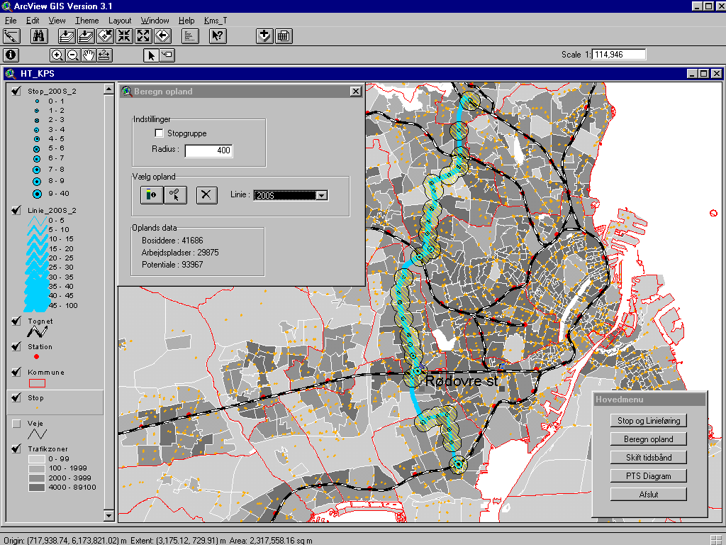
The very calculations of catchment areas are one example of the advantages of GIS. The entire HT area (traffic area) is divided into traffic zones crossed by services, which not always follow the zones. HT knows the number of people living in every zone but this is not enough to say anything about how many people intending to use a stop being placed on a certain spot of a route. With GIS you can draw a circle with the stop as center and afterwards have calculations of the number of customers contributed by the people in the very traffic zones.
Goals of quality have been set for the maximum walking distance to the stop, depending on down town surroundings or towns in the country. In the catchment area calculations we use circles with a radius corresponding to the walking distance. (we must multiple the circle radius by app. 1,1-1,2 to have the real walking distance.
The catchment area of service 200S. The overlaps between catchment area of adjacent stops have been taken into consideration so that they are not calculated twice. The background map (traffic zones) shows the population density.
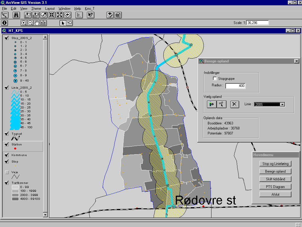
Catchment area of service 200S with zoom on the community of Rødovre (Copenhagen suburb).
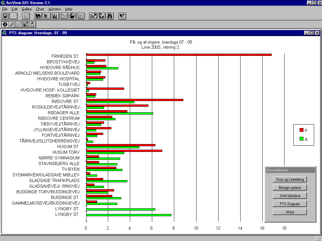
This diagram illustrates the average number of entering (red) and exiting (green) customers of a stop within the time band chosen (service 200S direction 2). Obviously there are especially many entering/exiting customers at railway stations.
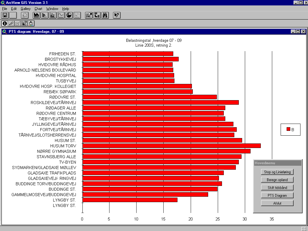
This diagram shows the average occupancy on service 200S on the distance between two stops in a chosen time band.
Service 200S has a satisfying occupancy in its whole route. From Rødovre station to Buddinge station some part of the trips counted is likely to have customers standing up.
As mentioned earlier KIM is used to calculate the average number of entering and exiting customers and occupancy for a chosen time band between two stops and in a particular direction of a service. The variation of entering and exiting customers and occupancy among the trips counted is smoothed.
Also we can show a diagram where entering and exiting customers and occupancy are enumerated within the chosen time band.
In the work creating an application for the MEET project we have used the KIM application as a point of reference.
The aim of the MEET project is to describe a model for identifying the need of meets between bus and train at railway stations.
The MEET project uses passenger countings for bus and train in a GIS application in order to calculate and represent:
The project also contains statistic data of population in order to calculate:
The MEET project is unique in its way of combining and representing two different data types (with different data structure). The two data sets mentioned are bus and train countings.
The Annual Counting made by DSB, Danish Rail, is passenger counting in trains; the number of entering and exiting passengers at stations is registered together with information of commuting (OD-matrix). Data of the Annual Counting are registered as real time at stations (consists of 11 files (summation is one file) – from which 6 new files are created. The files correspond each of the 5 time bands and a summation. Together with the bus file the 6 files are stored into a database (Microsoft Access) which will be activated once the project is started. Having started the application you can choose between different databases for each year being counted, e.g. data set winter 1997/1998. The application is build up demanding a minimum of maintenance when a new database with bus and train countings is to be created, this will happen as a minimum on a yearly basis.
The PTS data are adjusted so that the arrival and departure times of the buses are corresponding the exact time of day, i.e. real time at the station. In KIM the departure time at the first place is used in the time bands.
Only the services having stops at or in very close distance of a station are
extracted from PTS-data. Additionally data is captured from the stop before or at the station only.
The Annual Counting covers all railway stations on Seeland and Lolland/Falster, two islands in Southern Denmark. This project is limited only to cover railway stations in the HT area.
The MEET project is built up as an application to ArcView Network Analyst. In the project the network of rail is combined of many pieces of line connected to each other. Network Analyst calculates the shortest way on the railroad network between two stations. In order to calculate the number of entering and exiting customers at a railway station data on all part distances on the entire railway network is accumulated (direction/entering –destination/ exiting – origin). Hypothetically a detour can be faster than the straightest way.
The MEET application is based on the following data sources (themes):
Due to the fact that the Annual Counting is performed on a weekday, only data from this day type is available. In order to decide the most important meets it is necessary to examine various time bands over the day to evaluate the travelling patterns being used. KIM uses the same time bands on weekdays.
The application is used for analysis of the number of bus and train passengers, the bus and train catchment area and to compare stations having similar geographic areas of service. From graphics an evaluation if a station’s has one or more time band(s) with a good or poor use of bus or train capacity in comparison to other time bands is available. (calculate proportionals).
If that is the case a reasonable explanation may be a good/poor meet between bus or train or more passengers within morning or afternoon rush hours are car driving or bicycling to the station. That means that there are less bus customers within the two time bands in relation to the other time bands seen in relation to the number of train passengers. Additionally more pensioners are using the buses in mid day.
Also it is possible to make before/after surveys of services at a station (comparison of winter ‘97/’98 with winter ‘98/’99) A consequence estimate of previous planning is hereby available.
An option of calculating bus and train catchment area in a self-chosen radius is available. A ‘standard calculation of the bus and train catchment area’ is taking place in the project after the following measurement: In the calculation (standard calculation) of catchment areas of stations and buses data is differentiated all after the station’s geographic area, e.g. with a 2000-metres radius in land area, a 1500-metres radius for the suburban communities and a 1000-metres radius within the community of Copenhagen. The bus catchment area is chosen according to the catchment area of the station except the kernel. The kernel is set to a radius of 700, 5000 or 300 meters in the three zones.
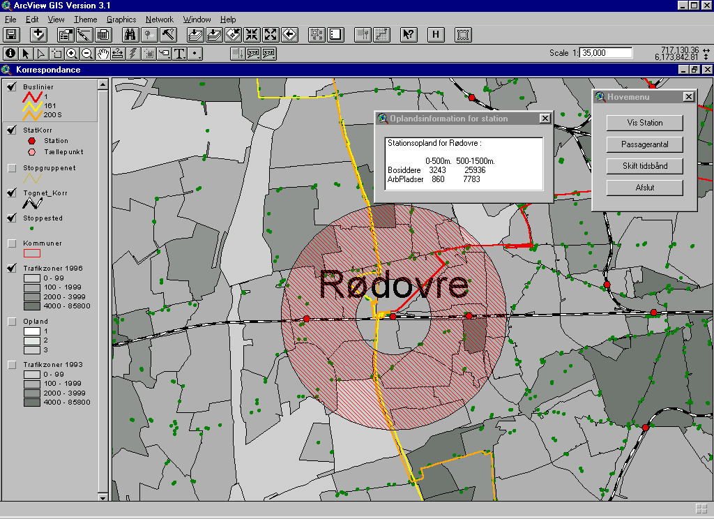
This diagram shows the catchment area of bus and train for Rødovre station. The background map (traffic zones) displays the population density.
In order to create one of the two diagrams you need to choose one of two ways of interchange:
The direction is registered, i.e. destination and origin.
It is impossible to know the number of passengers changing between the two means of transport - that must be based on surveys on changing patterns at stations, estimates, experience and comparisons.
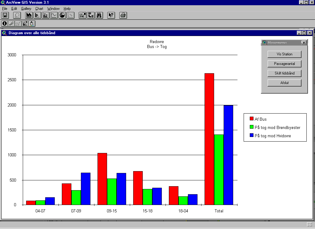
This diagram totalises the number of exiting bus customers and the number of entering train passengers (divided into directions) divided into the five time bands and a total for time bands.
The diagram gives a good overview of the number of passengers in bus and train over the 24-hour. It is also possible to calculate proportionals between bus and train for all time bands.
Mornings between 7 and 9 a.m. the connection with the train to Hvidovre is to be prioritized. (Vise versa in the afternoon between 3 and 6 p.m.) Twice as many passengers go by train in that direction. In other time bands none of the direction are demanding connection prioritized to the other. Furthermore the connection will depend of the service network, where some services are more obvious as a service bringing customers to the train than a service bringing passengers from the train in comparison to others.
The time band 9 a.m.- 3 p.m. (and 3 p.m. - 6 p.m.) have many customers compared with mornings 7 a.m. - 9 a.m.)
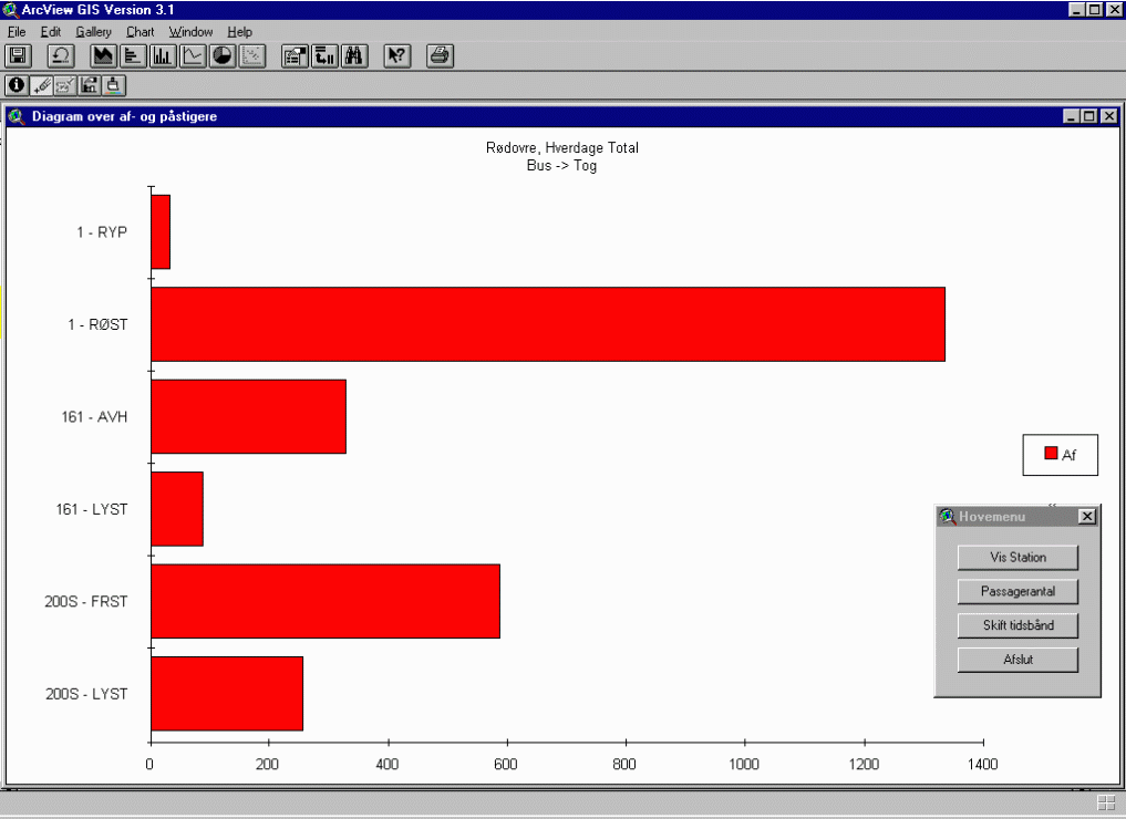
The above diagram divides the number of exiting bus customers into service, direction and a chosen time band. Here you can evaluate the services needing connection with the train.
There is a great variation in the number of customers exiting the services at Rødovre station.
The KIM and MEET projects are two applications supporting and supplementing each other. The applications are used for analyzing and evaluating bus and train data captured.
The conclusions drawn are used for planning of new schedules.
It is of great importance to have a build up of experience with regard to the use of applications and results because of the ability of quite new and more detailed analysis of public transportation.
Translation: Carsten Blom