Evaluation of the vulnerability to pollution in Metline aquifer. (North-East of Tunisia)
Abstract
The aquifer of Metline is located in the North of Tunisia and represents an alluvial aquifer facing the Mediterranean sea. DRASTIC model was applied with GIS system to evaluate the vulnerability of the aquifer to pollution. Data related to the study area and corresponding to seven critical factors of the model (Depth to water, net Recharge, Aquifer media, Soil media, Topography, Impact of the vadoze zone and hydraulic Conductivity), were collected and converted by the GIS system to maps. Weights and indexes were attributed to the factors according to their importance in the vulnerability model. By summing the product of weights and indexes of the critical factors, a detailed hydrogeological vulnerability map was obtained, showing five classes of potential pollution of the aquifer.
I- INTRODUCTION
As stated by numerous authors, pollution potential is a combination of a hydrogeologic factors, anthropogenic impacts or influences, and contamination sources in a given area or watershed.
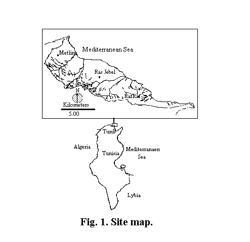
This paper is aimed at determining the aquifer pollution potential index and the degrees of vulnerability within the aquifer of Metline situated in Northeast Tunisia ( Fig. 1 )
The watershed facing the Mediterranean Sea covers 50 km2 in the study area and is bordered Northeast by the plain of Metline-Ras Jebel which occupies 50% of the total surface and Southwest by hills never exeeding 300 m in altitude. This zone has a semi-arid climate justifying the appropriate DRASTIC model used.
A similar study supported by AVICENNE project (93-AVI-099-HYDROmed) was carried out by Added A., Ben Mammou A. and Marzougui Y. with the European partners (D'appolonia from Italy, University of Nice and University of Malta) in Manouba aquifer in Tunisia.
Studies on the vulnerability of aquifers in Tunisia were achieved by Marzougui (1995) and Hamza (1999) within the framework of academic research.
II- METHOD
DRASTIC method (Aller et al., 1987) including only the hydrogeologic factors which influence pollution potential was used with computer implementation within a GIS system (ARC/INFO and IDRISI) to asses the hydrogeologic vulnerability of the aquifer. The method is based on seven critical factors:
1) Depth to water
2) Net Recharge
3) Aquifer media
4) Soil media
5) Topography
6) Impact of the vadose zone
7) Hydraulic conductivity
The evaluation of vulnerability was conducted according to the following steps:
- Identification of the most suitable potential terms (classes) for each critical factor and definition of the corresponding degrees of impact (indexes). This is done with reference to seven tables of class-index assignment. Each table is referred to a single critical factor;
- Definition of the relative influence of each critical factor (Weights);
- Definition of an algorithm which combines all factor impacts (indexes), taking into account their relative influence (weights) on the aquifer vulnerability assessment, in order to compute the vulnerability indexes.
In order to elaborate the vulnerability map, the study zone was analyzed under a raster (grid) scheme and divided into subareas and cells, each one provided of appropriate index values. The raster scheme allows the elaboration of thematic maps for each critical factor through the visualisation of zones with different class index values. An aquifer pollution potential index and a degree of vulnerability are then assigned to each sub-area, based on the summation of the single risk-index values, thus representing as a condensed index a useful tool in territorial planning.
III- ASSIGNMENT OF NON-DIMENSIONAL INDEX TO FACTORS
A non dimensional index is proposed to be assigned to each critical factor, based on appropriate parameters or soil characteristics, which constitute specific classes within the factor. A class can be represented by a range of values for a physical parameter (i.e., hydraulic conductivity or depth of water) or by a media type (such as lithological description for aquifer and soil media). The non-dimensional indexes associated with each class increase from 1 to 10 with the increasing aquifer pollution potential.
For each critical factor a specific table has been generated (93-AVI-099-HYDROmed) to allow the index assignment to the classes. The proposed classes include all parameter values or soil characteristics considered to be representative of the hydrogeologic settings in Southern Mediterranean Basin. The tables list the defined classes with respect to the aquifer pollutant protection, starting from the most favorable condition (index value equal to 1) down to the most critical one (index value equal to 10).
IV- WEIGHTS OF THE CRITICAL FACTORS
Each critical factor has been analyzed and comparatively evaluated with respect to others in order to define its relative importance in the vulnerability assessment. This relative importance is defined as weight of the factor. The proposed weights have been assigned by means of a Ranked pairwise Comparison Technique, resulting from analysis of case histories and expert judgments, and may not be changed. The weights range between 1 and 5, according to their increasing importance in vulnerability assessment:
Depth of water = 5,
Net Recharge = 4,
Aquifer media = 3,
Soil media = 2,
Topography = 1,
Impact of the vadose zone = 5,
and Hydraulic conductivity = 3
It should be noted that the highest weights have been assigned to the factors affecting path way and length of an infiltrating contaminant/contamined water from the ground surface to the water table.
V- AQUIFER POLLUTION POTENTIAL INDEX AND DEGREE OF VULNERABILITY
As previously described, critical factors have been defined, and within each factor appropriate classes have been selected, in order to standardise available basin data. By determining and tabulating index values for each class, and by defining constant weights for each factor, the following summation allows the determination of the aquifer pollution index for each grid sub-area:
V = å PiSi
where:
V = Aquifer pollution potential index
Pi = weight of the i-th factor
Si = index of the i-th factor
Values obtained represent a measure of the aquifer hydrogeologic vulnerability, ranging from a minimum value of 24 to a maximum of 226. The higher the computed value, the higher the hydrogeologic vulnerability to percolating contaminants. The degree of vulnerability can be determined, based on the following assessment criteria:
Low hydrogeologic vulnerability, if V< 80;
Medium hydrogeologic vulnerability, if 80 £ V < 120;
High hydrogeologic vulnerability, if 120 £ V < 160;
Very high hydrogeologic vulnerability, if 160 £ V < 185;
Extremely high hydrogeologic vulnerability, if V ³ 185
VI- THE SEVEN CRITICAL FACTORS USED TO DETERMINE THE HYDROGEOLOGIC VULNERABILITY OF THE AQUIFER
VI-1 DEPTH TO WATER
Depth to water constitutes the thickness of ground a contaminant must travel before reaching the ground water table. It consequently impacts on the degree of interaction between the percolating contaminant and subsurface materials (air, minerals, water) and, therefore, on the degree, extent, physical and chemical attenuation and degradation processes. In general, the aquifer potential protection increases with depth to water. Piezometric data obtained from 60 wells in the basin of Metline-Ras Jebel-Raf Raf were used to provide the depth to water map showing the seven classes of the DRASTIC model ( Fig. 2 ).
Corresponding indexes of these classes are shown in Table1 .
Table1. Classes of Depth to water found
in Metline aquifer
|
|
|
|
|
|
|
|
|
|
|
|
|
|
|
|
|
|
|
|
|
|
|
|
VI-2 NET RECHARGE
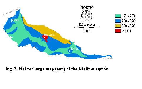
The net recharge is defined as the amount of water from precipitation and artificial sources available to migrate down to the ground water. Recharge water is, therefore, a significant vehicle for percolating and transporting contaminants within the vadose zone to the saturated zone. Net recharge is calculated on an annual basis by summing each monthly data obtained from: precipitation, artificial recharge, superficial run-off, ground moisture content, evaporation and plant transpiration. The algorithm allowing the net recharge calculation is:
Ri = (Pi + IRi - r/Oi - D STi - AETi) (93-AVI-099-HYDROmed)
where:
Ri = net recharge in the i-th month (mm)
Pi = rainfall in the i-th month (mm)
IRi = artificial recharge in the i-th month (mm)
r/Oi = superficial run-off in the i-th month (mm)
D STi = variation of the ground moisture content in the i-th month (mm)
AETi = actual evapotranspiration in the i-th month (mm)
Relevant information about each term of the above presented algorithm was derived from the following data sets:
- Rainfall term (P) was obtained from available precipitation data in the study area.
- Artificial recharge(IR) term was obtained from irrigation data provided by EPI service of Ras Jebel.
- Superficial run-off (r/O) term was determined by means of the following algorithm:
r/Oi = (Viessmann et al., 1977)
where:
Pi = rainfall in the i-th month (mm)
and :
where:
CN = Curve Number which is a tabulated coefficient varying with land use and soil moisture content (Viessmann et al , 1977; U.S. Department of agriculture, 1972).
-Variation of the soil moisture content (D ST) was obtained following these equations:
D STi = (P - r/O - ETP)i
for (P - r/O - ETP)i > 0
and STi+1 + D STi £STmax
D STi = STmax - STi-1
for (P -r/O - ETP)i > 0
and STi-1 + (P - r/O - ETP)i > Stmax
D STi = STi-1 (e (P-R = - ETP)i /STmax - 1)
if (P - r/O - ETP)i £ 0
where:
STmax = Maximum soil moisture (mm/month)
STi = Soil moisture content in the i-th month (mm/month)
This parameter was determined in the study area by using the tabulated coefficients obtained from Centerton (1957)
ETPi = Potential evapotranspiration in the i-th month (mm/month), value obtained from Thorntwaite's relation:
ETPi = 16Li (10 ti/I)a (mm/month)
in which:
Li = Monthly latitude coefficient
ti = Temperature in the i-th month (oC)
I = Annual thermal index ; I =mi
mi = Monthly thermal index; mi = (t/5)0.514
a=1.6/100 I + 0.5
- Actual evapotranspiration (AET) was obtained as follows:
AETi = ETPi (mm/month)
If (P - r/O - ETP)i ³ 0
AETi = (P - r/O - D ST)i (mm/month)
If (P - r/O - ETP)i < 0
Maps obtained from each term discussed above were summed to obtain the net recharge map of the Metline aquifer which has been classified following the DRASTIC model ( Fig. 3 and Table 2).
Table 2. Classes of net Recharge found
in Metline aquifer
|
|
|
|
|
|
|
|
|
|
|
|
|
|
|
VI-3 AQUIFER MEDIA
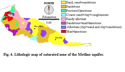
Aquifer refers to the portion of ground capable to yield water in pores.
The contaminant attenuation of aquifer depends on the amount and sorting
of fines. In general, the lower is the grain size, the higher can be assumed
the attenuation capacity of aquifer media. Information needed to evaluate
this critical factor was obtained from boring logs by Aouali (1967), Ennabli
(1969) and Hydroservices Society, and from a hydrogeologic map established
by Drogue (1966).The lithologic map of the Metline aquifer (
Fig. 4 ) shows eight lithologic classes for which indexes are shown
in Table 3.
Table 3. Classes of aquifer lithology found
in Metline aquifer
|
|
|
|
|
|
|
|
|
|
|
|
|
|
|
|
|
|
|
|
|
|
|
|
|
|
|
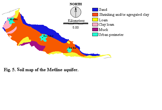
VI-4 SOIL MEDIA
Soil media is the uppermost and weathered part of the ground, which
is characterized by significant biological activity and exchanges with
the atmosphere. Soil cover characteristics influence the surface and downward
movement of contaminants. The presence of fine grain size materials, such
as clay, peat or silt, and the remarkable percentage of organic matter
within the soil cover can decrease intrinsic permeability, and retard or
prevent contaminant migration via physico-chemical processes (i.e., adsorption,
ionic exchange, oxidation, biodegradation). Soil cover characteristics
of the study area were derived from the soil association map (Barbery and
Delhumeau, 1979), and the indexes of soil classes were determined according
to tables of DRASTIC model (93-AVI-099-HYDROmed) ( Fig.
5 and Table 4).
Table 4. Classes of Soil cover characteristics found
in Metline aquifer
|
|
|
|
|
|
|
|
|
|
|
|
|
|
|
|
|
|
|
|
|
VI-5 IMPACT OF THE VADOSE ZONE
The vadose zone is defined as the ground portion found between the aquifer and the soil cover in which pores or joints are unsaturated or only discontinuously saturated. The vadose zone influence on aquifer pollution potential is essentially similar to that of soil cover, depending on its permeability, and on the attenuation characteristics of the media.
Most of the physical and chemical processes taking place in this zone (i.e., biodegradation, oxydation-reduction reactions, volatilisation) are strongly influenced by depth. Filtration and dispersion are remarkably impacted by the media physical characteristics, which control path ways and path length within the layered subsurface environments.
Information for the evaluation of this critical factor was obtained by the interpretation of geologic data collected on the study area (Burrolet 1951, Ennabli 1969, Bizon et al. 1974, Rouvier 1977, Ammar 1986, Burrolet and Bismuth 1993).
The lithologic map of the vadose zone and the indexes of lithologic classes are shown in Fig. 6 and Table 5.
Table 5. Classes of vadose zone properties found
in Metline aquifer
|
|
|
|
|
|
|
|
|
|
|
|
|
|
|
|
|
|
|
|
|
|
|
|
|
|
|
|
|
|
|
|
|
VI-6 TOPOGRAPHY
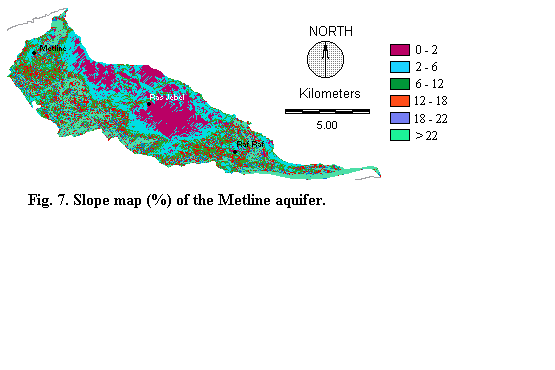
Topography will give an indication on whether a pollutant will run off or remains on the surface long enough to infiltrate into the groundwater (Lynch et al., 1994).
Four topographic maps (1/25.000 scale) were used for the slope assessment in our study area: Ghar El Melh Northeast, Ghar El Melh Northwest, Metine Southeast and Metline Southwest. The topographic map covering the study area was obtained by joining the four maps cited above using MAPJOIN command of PC ARC/INFO. This map was then transferred to IDRISI, which allowed the slope map determination, showing ( Fig. 7 )
the six classes of the DRASTIC model. Table 6 shows the indexes of these classes.
Table 6. Classes of Topography (Surface acclivity) found
in Metline aquifer
|
|
|
|
|
|
|
|
|
|
|
|
|
|
|
|
|
|
|
|
|
VI-7 HYDRAULIC CONDUCTIVITY
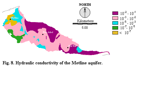
Aquifer hydraulic conductivity refers to the ability of the aquifer formation to transmit water. It depends on the amount and degree of interconnection between empty spaces inside the rock media. This critical factor controls the contaminant migration and dispersion from the injection point within the saturated zone and, consequently the plume concentration in the aquifer.
By using transmissivity data (Ennabli, 1973), and the lithologic map of the aquifer, the hydraulic conductivity of Metline aquifer has been determined. Transmissivity data were used to calculate the hydraulic conductivity in the East zone of the watershed via the following equation:
K = T/b (m s-1)
Where:
K= hydraulic conductivity ( m s-1)
T = Transmissivity (m2 s-1)
b = thickness of the aquifer (m) which was estimated through the available boring logs in the study area.
For the remaining zone of the study area, the hydraulic conductivity was determined by redefining the lithologic classes of the aquifer following the tabled hydraulic conductivity varying with lithology (93-AVI-099-HYDROmed).
Finally, all these data allowed the establishment of the hydraulic conductivity map of Metline aquifer ( Fig. 8 ) , showing five classes for which indexes were attributed(Table 7 ).
Table 7. Classes of hydraulic conductivity found
in Metline aquifer
|
|
|
|
|
|
|
|
|
|
|
|
|
|
|
|
|
|
VII- HYDROGEOLOGIC VULNERABILITY OF THE AQUIFER
Maps derived from the study of the seven critical factors were multiplied by the assigned weights, then were summed allowing the determination of the vulnerability index map of the Metline aquifer. Hence, the found indexes were classified according to the vulnerability assessment of the DRASTIC model, and the vulnerability map of Metline aquifer ( Fig. 9 ) was defined including five degrees of vulnerability like that mentioned above.
VIII-CONCLUSION
By using GIS, we have been able to apply the DRASTIC model in order to determine the vulnerability map to pollution of the Metline aquifer. The map reflecting the facility with which a contaminant could infiltrate the ground water shows high degrees of vulnerability in most zones of the study area. However, extremely high degrees of vulnerability noted in coastal zones could incite the local community to first preserve these zones.
The present map can be used only to detect the hydrogeologic vulnerability at a large scale (1/135000) in the study area. We hope that in the future more dimensional and non dimensional data provided by researchers could allow to obtain more precise maps of vulnerability in Tunisia.
REFERENCES
Aller L., Bennet T., Lehr J.H., Petty R.J. and Hacket G. (1987) DRASTIC: a standardized system for evaluating groundwater pollution using hydrological settings. Prepared by the National water Well Association for the US EPA Office of Research and Development, Ada, USA.
Ammar H. (1986) Hypothèses pour un modèle d'évolution dynamique des bassins de la basse vallée de Mejerda. DEA, Université de Tunis II, 106 p.
Aouali A. (1967) Metline-Ras Jebel-Ghar El Melh, sondages de prospection avec étude de perméabilité, Rapport interne DGRE, 7/54.
Barbery J. et Delhumeau M. (1979) Carte des ressources en sol de la Tunisie au 1/200000, feuille de Bizerte. Division des sols, Ministère de l'agriculture.
Bizon J.J., Burrolet P.F. et Jelisejeff A. (1974) Le pliocène de Raf Raf (tunisie Nord-orientale), comparaison avec les séries de même âge observées en Espagne méridionale et dans les îles Ioniennes. Ann. Mines et Géol., pp 301-313.
Burrolet P.F. (1951) Etude géologique des bassins Mio-Pliocènes du Nord Est de la Tunisie. Ann. Mines et Géol. n7. 82 p.
Burrolet P.F. et Bismuth H. (1993) Les molasses du Nord Est de la Tunisie. Colloque RCMNS, Tunis, pp 1-12.
Centerton N.J. (1957) Instructions and tables for computing potential evapotranspiration and the water balance. Climatology, Vol. 10, n3, pp 185-311.
Drogue C. (1996) Carte des ressources en eaux souterraines de la Tunisie (1/200000), feuille de Bizerte.
Ennabli M. (1969) Etude hydrogéologique de la plaine de Ras Jebel. DGRE, 7/57, 134 p.
Ennabli M. (1973) Hydrogéologie de la plaine de Ras Jebel-Raf Raf. Ann. Mines et Géol. n26, pp 537-561.
Hamza M.H. (1999) Etude de la vulnérabilité à la pollution potentielle de la nappe de Ras Jebel par les systèmes d'information géographique. DEA, Univ. Tunis II, 102 p.
Lynch S.D., Reynders A.G. and Schulze R.E. (1994) Preparing imput data for a national-scale groundwater vulnerability map of southern Africa. Document Esri94.
Marzougui Y. (1995) Etude de la vulnérabilité des aquifères à la pollution. Application à la nappe de Manouba (Tunisie). DEA, Univ. Tunis II, FST, 72 p.
Rouvier H. (1977) Géologie de l'extrême Nord Tunisien: tectonique et paléogéographie superposées à l'extrémité de la chaîne Nord-Maghrebine. Thèse de 3ème cycle, Université Paris VI, 898 p.
U. S. Department of Agriculture (1972) SCS National Engineering Handbook. Section 4, Soil Conservation Service, Washington, DC, USA.
Viessmann W., Knapp J.W. and Lewis G.L. (1977) Introduction to hydrology.
2nd Edition, Harper and Row, New York, pp 618-625.