Daniel J. Sandhaus
ALFA is an ArcView-based facilities management, space management, and environmental management application, utilizing a relational database linked with associated maps and building floor plans. Using ArcView, Oracle, Microstation and a Visual Basic interface, users can select objects on maps or floor plans, retrieve pertinent data records or other information including photographs or text based documents. Conversely, executed database queries retrieve GIS/CAD object matches. ALFA is being developed for the U.S. Navy, Chief of Naval Education and Training Command.
In 1995, the U.S. Navy Chief of Naval Education and Training (CNET) initiated the ALFA program to establish a single, comprehensive, and integrated source of activity information wherein database records are linked with graphical objects (i.e., maps and floor plans). ALFA requirements included the capability for information from each CNET activity to be electronically transmitted to a data warehouse at CNET headquarters, and to provide secure access to all potential users of CNET environmental, land, and facility data.
ALFA is a tool to support facilities and environmental planning and management decisions. It was developed under the supervision of the Naval Facilities Engineering Command (NAVFAC) Southern Division. The ALFA 4 application is currently being installed at CNET sites in the South Texas, Pensacola, Athens, Meridian, and Great Lakes regions.
Activity (site) personnel using the client/server application maintain information in the system. The operational data maintained at each installation is replicated, transferred, and aggregated into the data warehouse at CNET headquarters. Any installation personnel with access to the Internet and an authorized password can view and query environmental and facility information using a Web browser interface. The data warehouse presently stores over 40 million square feet of facility floor plans and approximately 80,000 acres of aerial mapping of nine installations. As technology continues to evolve, the role of databases in managing information of all types will become more prominent.
Since its inception, the ALFA system has evolved from the workstation, to the local area network and then to the Internet, and has become an enterprise and distributed system. The enterprise system now consists of two User interfaces: a Web-based interface to view and query data in the data warehouse, and a client/server application for editing and maintaining the data. Changes in this fourth generation of ALFA (ALFA 4) include migration of the database to Oracle, development of a new Visual Basic user interface, addition of environmental database modules, and a customized ArcView application for accessing, viewing, and analyzing graphic and geographic data.
The new environmental modules included in the ALFA 4 application are:
Addition of the ArcView module brings new functionality to the ALFA application. The spatial analysis capabilities of ArcView can now be used on the General Development Map (GDM) and floor plan drawings. This includes functions such as locating features based on their attributes, buffering, and theme-on-theme selection. CAD files from AutoCAD and Microstation can be brought into ArcView using the CADReader extension.
The ALFA 4 database includes Facilities and Environmental data modules. The facilities module includes building and room information.
Maps associated with the database are of two types:
Map and floor plan drawings are created and edited in Microstation. Map features are linked to the database in Microstation. Attributes of map features are entered into the Oracle database through the Visual Basic user interface. ArcView is used for viewing and analyzing the data. However, maps and data tables are read-only in ArcView.
The ALFA 4 database includes a Drawing module that tracks what drawing are available for each installation and for each building. Data stored in the drawing module is used by the ArcView application to locate the drawing files and to set some display features. The drawing file paths, theme definitions, legend file paths, and SQL queries for joins can be stored in the ALFA 4 Drawing module.
Map and floor plan data can be viewed and queried in both CAD and GIS. Custom applications were developed in Microstation, AutoCAD, and ArcView for viewing and querying data. Use of ArcView GIS also provides the capability of performing spatial analysis on the data, providing a new tool to support strategic decision-making.
The ALFA 4 application has a function called "Related Data" that allows the linking of any electronic data to a database record or map feature. Map features are linked to the database. Map features and data records can also linked be linked to any number of related documents such as photographs, spreadsheets, or reports through the Related Data function.
ArcView programming was accomplished using the Avenue programming language. The ALFA 4 functions for ArcView are delivered as an extension called "ALFA GIS". Communication with the Oracle database is made using an ODBC connection. Data selections are passed between ArcView and the Visual Basic application using DDE. A temporary data file is generated for each selection and the DDE message essentially tells the receiving application to read the data file. Dialog Designer was used to make the view creation and map manager feature. Some variables used in the Avenue scripts are read from the registry using Windows API calls.
The customized functions included in the ALFA GIS extension include:
When the ALFA GIS extension loads, several actions occur. An ODBC connection is made to the ALFA database, and the user is prompted to logon to the Oracle database. The CADReader and MrSID image Support extensions load. Two queries are made to the ALFA database. The first query retrieves a list of Activity Areas (sites) in the database and creates the ActArea table. The second query retrieves a catalog table that relates graphic object types with tables in the database. Each type of graphic object, such as air emissions source, tank, etc., is associated with a corresponding table in the database. The catalog table establishes these associations.
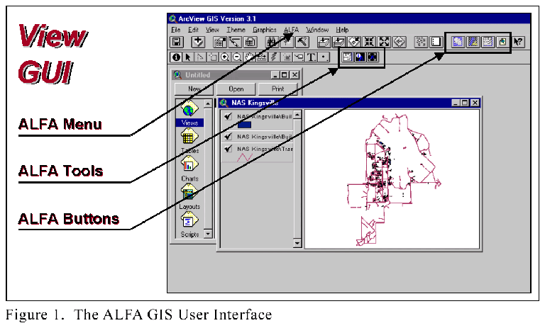
ALFA GIS adds GUI elements to the Project and View GUIs. In the Project GUI, an ALFA menu is added that contains one command: Create View. In the View GUI, ALFA adds a menu containing three commands, four buttons, and three tools (Figure 1).
The "Create View" command enables the user to quickly create a new view of GDM map layers, or to add map layers to an existing view. The "Create View" function is accessible from an ALFA menu command in the Project GUI, or from an ALFA menu command or a button in the View GUI. The "Create View" dialog box acts as the drawing manager for GDM themes.
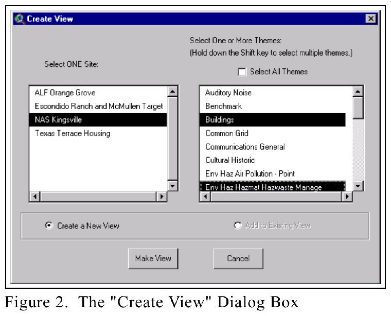
The Create View dialog was made using Dialog Designer (Figure 2). The Site list box is populated from the list of Activity Areas (ActArea table) that was made when the extension was started. The Theme list box is populated dynamically based on the site selection. Only one site may be selected. Multiple themes can be selected by holding down the shift key. There is also a "Select All Themes" checkbox above the Themes list box that toggles the theme selection between having all or none of the themes selected.
Below the Site and Themes list boxes, two radio buttons allow the user to choose to either create a new view, or add to an existing view. The option to add to an existing view is disabled if there are no existing views.
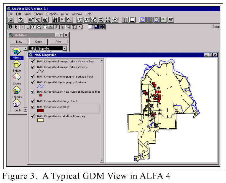
When the user clicks on the "Make View" button, a window opens prompting them to name the new view. A default view name is given, but another name can be entered. After entering a name, the view will be created (Figure 3). For any drawings (themes) that include text, the text will automatically be added as a separate theme (remember when adding a CAD theme, you must select point, line, polygon, or annotation). Themes are named automatically with the form site name/theme name. The Map Units and Distance Units for the view are automatically set to feet.
One of the principal functions of the application is to select features in the database and locate them on a map, or conversely, to select features on a map, and get their attributes from the database. The database has a powerful Query Builder tool that enable a user to specify criteria for filtering and selecting data. Once a set of records is selected in the database, the linked features can be located on the GDM maps or floor plan drawings. When the "Locate Object(s) on Drawing" command is invoked in the database application, ArcView is activated, and the view zooms in to the selected features.
If a single point feature is selected, the view zooms in to a scale of 1:1000 centered on the point. This is a modification of ArcView’s default ‘zoom to selected’ script, that only centers on single points, but does not zoom in near them.
It is possible that features selected in the database are present in several views within the current ArcView project. In this case, A list box showing the possible views is displayed and the user selects one.
Features can also be selected in ArcView, and their attributes can be found in the ALFA database. The "Show Selected Data in ALFA" command can be invoked from a menu or a button in the View GUI. A tool in the view GUI will issue this command for one object when the user applies the tool in the view.
This is where ArcView’s spatial analysis tools are likely to be used for analysis and problem solving. For example, the user might want to find all Installation Restoration (IR) sites that are located within floodplains. This is done using theme-on-theme selection (Select by Theme). Another example would be to find all buildings located within IR Sites. Buffering might be used to identify all features within a specified distance of another feature. Buffering might be used, for example, to locate features within the hazard zones of a weapons bunker, or to locate sensitive receptors near an air emission source. Site selection decisions can be supported by eliminating unsuitable sites, such as those within floodplains, sensitive ecosystems, IR Sites, hazard zones, etc. Proximity to utilities can also be measured or evaluated for potential site selection. Regardless of how the user chooses to select or analyze features in the maps or floor plans, once the features are selected, their attributes can be located and viewed in the ALFA 4 database.
When making selections in ArcView, it is possible to select more than one type of feature at a time. This could happen by having multiple themes active in the view when dragging a selection rectangle, or by having multiple types of features in one theme. An example of the latter case can be seen in the wastewater drawing, which includes both oil/water separators and outfalls. However, only one feature type can be sent to the ALFA database at a time. When multiple feature types are selected, a dialog box appears asking the user to select only one type of feature.
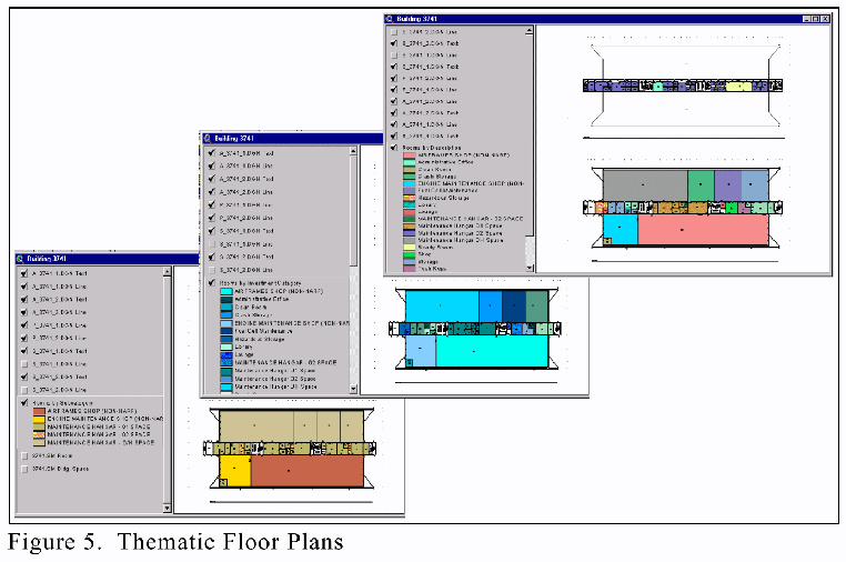
ALFA GIS has tools to quickly create views of building floor plans and to create thematic maps of room data. Features in floor plans are also linked to the database, and can be selected to see their attributes.
To open a building's floor plan, the Buildings theme must be active. The "Make Building Floor Plan" tool is then applied to a building in the view, and a new view is created that includes all of the floor plan drawings for that building. The user is prompted to name the view, and a default name is provided. When the floor plan view is made, a table is also created by a join of the drawing attributes and the database’s rooms table data. This joined table enables two functions: (1) making thematic maps of the building floor plans, and (2) using ArcView’s standard information tool to see room attributes.
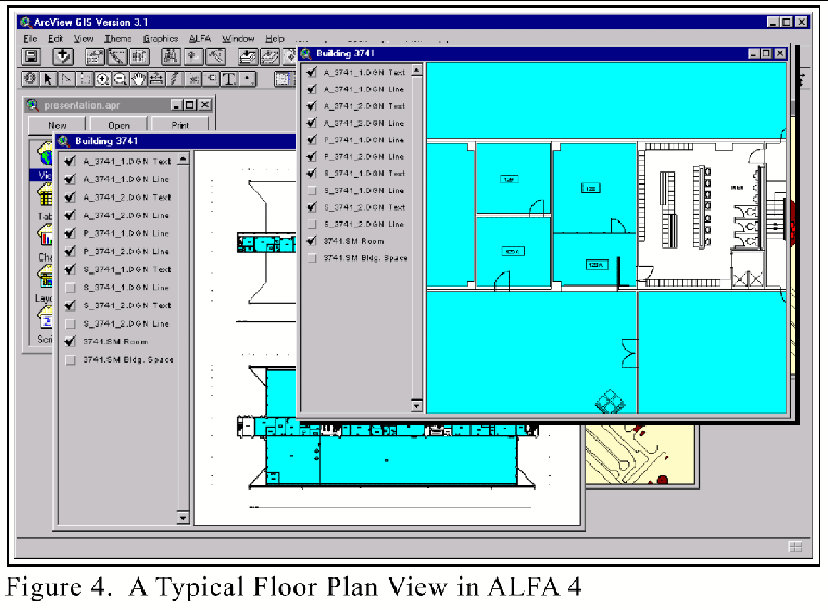
In building floor plan views, (Figure 4) the themes are organized so that text and lines are at the top of the Table of Contents and polygon themes are near the bottom. The Room Space theme is turned on, and the Building Space theme is turned off. This gives the optimum view of floor plans where all of the details and text can be seen.
Thematic floor plans can be created based on attributes from the database. The "Thematic Floor Plans" menu command and button are enabled whenever a building floor plan view is active. Rooms can be classified by ten pre-defined attributes: Administrative Offices, Condition, Facility Category, Facility Subcategory, Investment Category, Occupant Department, Room Area, Room Description, Storage, and Tenant. This enables the user to quickly visualize and evaluate space management issues, such as:
This command is available when a floor plan view is active. A Thematic Floor Plans dialog box appears showing a list of room classifications. A classification type is selected, and a new theme is added to the floor plan view showing the rooms by that classification. The new theme is placed at the top of the polygon themes in the view’s Table of Contents to optimize viewing.
The Related Data feature allows any electronic data to be linked to a database. This is a powerful feature of the ALFA application. Any type of document can be associated with a feature, such as photographs, reports, spreadsheets, etc. For example, links can be made to a cost estimate for project, tank testing data, or a chemical analysis report. The Related Data function in ArcView uses a small Visual Basic (VB) application. ArcView sends a DDE message to the VB application that contains a feature’s link value. The VB application then runs a query to the Oracle database to find all documents that have been associated with the feature. The Related Data tool is applied to a feature in a view to bring up the list of associated documents.
ALFA is a Computer Automated Facilities Management system that was developed for the U.S. Navy that is used to support facilities and environmental planning and management decisions. It includes a Visual Basic application, Oracle database, Microstation CAD, ArcView GIS, and a Web application.
Features in the ALFA GIS extension for ArcView include:
Addition of the ArcView module brings new functionality to the ALFA application. The spatial analysis capabilities of ArcView can now be used on the General Development Map (GDM) and floor plan drawings. Virtually any type of electronic information can be linked to a map feature through the database, and can be accessed through ArcView.
Daniel J. Sandhaus
Software Developer
The Onyx Group
1199 North Fairfax Street, Suite 600
Alexandria, VA USA
Telephone: (703) 548-6699
E-mail: Dans@onyxgroup.com
Web Site: http://www.onyxgroup.com/