
Figure 1. EPA regulated facilities around San Diego Convention Center.
Vincent Zhuang, John Sun, Ren Hou, Matthew Moss, Seth Israel, Bryan McEnaney, Yi Zhou, Dalroy Ward, and Dave Wolf
EnviroMapper-Internet GIS Assisted Environmental Analysis Tool
In May 1998, the United States Environmental Protection Agency (USEPA)
introduced EnviroMapper, a new generation of Web-based environmental analysis
tools. Since then, EnviroMapper (http://maps.epa.gov) has
become one of the most visited sites. The application has an average
of 40,000 hits per day, more than one million times each month. EnviroMapper
gives users the power to query almost one million EPA-regulated facilities
through a web browser; it also generates text reports of environmental
information. EnviroMapper can be used to view and query environmental
statistics, profiles, and trends; environmental information for US metropolitan
areas; environmental information for watersheds; and Superfund cleanup
sites. The geospatial data that empowers EnviroMapper are stored
in EPA's National Shapefile Repository, which contains more than 20 Gigabytes
of spatial data. This repository utilizes technology called Virtual
Grid, which allows the data to be retrieved efficiently through the Web.
The latest version of EnviroMapper takes advantage of Esri's Spatial Database
Engine (SDE). EnviroMapper can access multiple SDE databases that
are at distinct remote locations. OpenLink, another EnviroMapper
feature, allows users to request map images directly from EnviroMapper
via HTTP protocol, and integrate them within their own web pages. OpenLink
Wizard facilitates OpenLink by automatically generating the HTTP protocol
based on user-entered criteria, meaning that less-technical users can enhance
their web pages with EPA's environmental information. This "open architecture",
which affects both data and application architecture, allows EPA to come
closer to achieving its goal of making its enterprise information readily
available to the public.
INTRODUCTION
The Environmental Protection Agency (EPA) produced the Envirofacts Warehouse, a web-based data warehouse containing all types of EPA environmental information. The Envirofacts Warehouse Website (http://www.epa.gov/enviro), boasting 1/2 million hits per month, provides the public with access to information in the warehouse online. Through the website, the public is able to retrieve environmental information from EPA databases containing information relating to Superfund sites, drinking water, toxic and air releases, hazardous waste, water discharge permits, and grants information. The Envirofacts Warehouse Website also provides online mapping of EPA facility locations, as well as underlying geographic features, such as streets, water bodies, and Zone Improvement Plan (ZIP) code boundaries.
EnviroMapper (Figure 1), the newest feature available through the Envirofacts Website, is a web-based interactive mapping application which displays Envirofacts facilities, and also provides environmental statistics, community-based environmental information, aquatic health information, and locations of Superfund cleanup sites. EnviroMapper is available for the public at http://maps.epa.gov.
The ultimate goals of the EnviroMapper project are to provide an enterprise-wide
GIS solution to EPA and a societal GIS solution to other agencies and the
public, and to provide a valuable Internet GIS-assisted environmental analysis
tool to all users.
Figure 1. EPA regulated facilities around San Diego Convention Center.
The first version of EnviroMapper was released in May 1998. Since
then, it has become increasingly popular all over the world. By June 1999,
the total number of monthly hits of EnviroMapper reached over 1.2 million.
Due to its ease of use and content-rich information, EnviroMapper has also
received public recognition. In October 1998, Government Computer
News (GCN) awarded EnviroMapper the GCN Agency Excellence Award; in May
1999, EPA presented EnviroMapper the EPA GIS Excellence Award; and Federation
of Government Information Processing Councils honored the Intergovernmental
Open System Solutions (IOSS) Gold Award to EnviroMapper in June 1999.
DESIGN OF ENVIROMAPPER
Users can access EnviroMapper through either 16- or 32-bit web browser, such as Netscape and Internet Explorer versions 3.x or later. Moreover, users can include a dynamically-generated map image in their own web page, using OpenLink (http://www.epa.gov/enviro/html/em/openlink.html). Any modification or update to the EPA geospatial databases will be automatically reflected in the map due to the live-link image source; no change is needed to the web page to keep the map current.
Development of GUI and Mapping Engine
The EnviroMapper Graphical User Interface (GUI) is a web page-it is composed of HTML text and forms. The GUI was developed with HTML 3.0 and JavaScript 1.1. In an effort to keep the EnviroMapper interface intuitive and user-friendly, there are no HTML frames. This type of design reduces the traffic between the map server and the client, making the process more efficient. Practical Extraction and Report Language (Perl) version 5.0 was used to develop a function that dynamically generates a list of cities, counties, and watersheds for a chosen state.
The GUI consists of two parts: the Main Map Display area (Figure 2) and the Zoom-in By Geography area (Figure 3). The Main Map Display area is configured using three columns, with the Legend on the left, Main Map Display in the middle, and the Locator Map Display and the main manipulation objects to the right. There are two buttons associated with each legend layer: a radio button (circle) for Query Selection and a checkbox (square) for Layer Feature Display. The radio buttons and checkboxes are HTML form objects. At the bottom of the Locator Map column, there is a checkbox to turn on/off the Locator Map. The map manipulation objects are located underneath the Locator Map. These objects are configured using radio buttons, checkboxes, scrolling menus, clickable images, command buttons and a navigation panel. The navigation panel enables users to pan the Main Map Display in eight possible directions: north, northeast, east, southeast, south, southwest, west, and northwest.

Figure 2. The main display area of EnviroMapper.
Spatial features selected by the user are displayed in the Main Map Display. At any given time, a single feature query or coordinate identification information is displayed beneath the Main Map display.
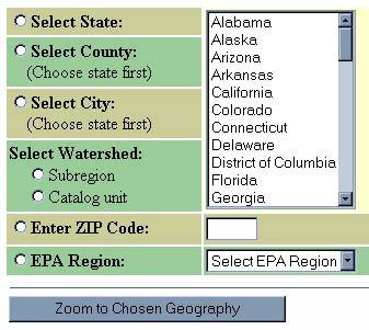
Figure 3. The Zoom-in By Geography area.
The Zoom-in By Geography area is located underneath the Main Map Display area. There are a series of radio buttons and scroll menus that allow users to Zoom-in by state, county, city, watershed, ZIP code, and EPA region.
The map engine was developed with Esri's MapObjects Version 1.2 and MapObjects Internet Map Server (IMS) Version 2.0 under the Visual Basic Version 5.0 environment. This server-side map engine (Zhuang, 1997) parses the request submitted from the client, generates a map and/or query results based on the processed request, and publishes the map and query results back to the client. The engine is composed of a collection of modules, with each corresponding to a HTML form element on the client interface.
Each map generated by EnviroMapper is in Graphics Interchange Format (GIF). A map is generated when a GIF request is submitted by the Web browser. The procedure for producing a map is to publish the HTML with all of the required parameters and generate the map based on those parameters. EnviroMapper stores all the parameters needed to generate a map on the client, so that each map can be generated independently.
Virtual Grids are created to provide a seamless mechanism for display of data from the EPA National Shapefile Repository. The use of Virtual Grids eliminates the need to load large volumes of spatial data into memory at once (Sun and Zhuang, 1998). Virtual Grids of county, state, ZIP code, and USGS Hydrologic Unit boundaries are used to load Shapefile data. These four virtual grids are referenced by the same set of cell identification values, thus making the management of multiple spatial layers appear vertically seamless.
Functionalities
EnviroMapper presents geographical features in three different nominal levels: national, state, and county. Switching from one level to another is controlled by the scale of the Main Map Display, and is done automatically by the map engine. The user can toggle any layer available in the Legend; layers differ depending on the level. After the selection, the user can click on the Redraw button to refresh the map. The user can also perform feature identification on any available layer. If the current theme is an Envirofacts facility layer, the user can launch the Envirofacts search engine on the identified site. Similarly, the user can launch search engines of environmental profiles, community-based environmental information, watersheds, and Superfund sites. EnviroMapper provides Zoom-in, Zoom-out, Pan, Identify, and Query options. Zoom-in can be by scalar, radius, ZIP code, city, county, state, watershed, or EPA region. Scalars and radii are available through a pulldown list; cities, counties, states, watersheds, and EPA regions can be selected from a listbox. If the user selects a scalar or radius Zoom-in and then clicks on the map, the map will zoom in by the chosen factor at the center of the clicked point; if the user chooses a city, county, state, watershed, or EPA region, or types in a ZIP code, the map will zoom in to the specified geographic extent. A zoomed window can be reset by clicking on the Zoom Reset button. The user can also request a printable map to download. Finally, EnviroMapper provides a Locator Map that shows the relative position of current main map window and the latitude and longitude coordinates.
OpenLink
EnviroMapper can dynamically publish map images that can be included in a web page. All these are accomplished through a new feature called OpenLink. OpenLink is a set of Hyper Text Transfer Protocols (HTTP) that:
http://www.epa.gov/cgi-bin/enviro/em/goenviromapper.cgi?name=enviroMapper&cmd=ZoomInByZip&code=22202&img=yesUse the protocol as the image source in a web page in the following fashion:
<IMG SRC="http://www.epa.gov/cgi-bin/enviro/em/goenviromapper.cgi?name=enviroMapper&cmd=ZoomInByZip&code=22202&img=yes">OpenLink Wizard (http://www.epa.gov/enviro/html/em/wizard.html) is a step-by-step guide available to users that generates an HTML string (see above) that the user can insert into his or her own web page. The Wizard pops up dialog boxes sequentially; each box contains a single question. After the user answers all of the questions, an HTML syntax line will be generated; the user just copies that line and inserts it into his or her web page.
System Configuration
The EnviroMapper map server consists of two Pentium server machines. One is a 200 MHz Pentium with four processors, 2 GB RAM, 8 MB VRAM, and 50 GB hard disk; the other is 450 MHz Pentium II with two processors, 1 GB RAM, 16 MB RAM, and 128 GB hard disk with hardware RAID controller. The operating system consists of a Windows NT Server 4.0 and a Netscape Enterprise Web Server 3.5, running under Windows NT 4.0.
Web Statistics
EnviroMapper version 1.0 was released in May 1998, and it had over 42,000 hits during the first month of the initial release. The number of visits reached 365,000 by the end of 1998. Version 2.0 was released in January 1999 with a frameless, easy-to-use graphical interface. Since this release, the application has become more popular, attracting an increasing number of users. By the end of June 1999, the number of monthly hits exceeded 1.2 million. Of those 1.2 million hits, 32% percent came from the .com domain, 21% from the .net domain, 10% from the .gov domain, 8% from the .edu domain, and the remaining 29% from other domains.
SUMMARY
EnviroMapper provides a comprehensive, web-based, GIS-assisted, environmental analysis tool to EPA and the public. The web page look-alike application represents a whole new generation of GIS development. EnviroMapper has combined the power of existing online queries and profiles in a virtual arena. EnviroMapper's OpenLink empowers concerned citizens with dynamically-published environmental maps and reports. The public can now insert dynamic, rather than static, maps into their web pages in a few simple steps. By offering such a powerful feature, EnviroMapper has genuinely innovated the approach to access environmental information through the public domain.
Recently, the concept of Open Data Access (also called Remote Data Access)
has been proven by the EnviroMapper project. Open Data Access means that
a user can connect directly to a remote data server, thus reducing the
duplication of existing databases and the burden to maintain these databases.
A prototype of Open Data Access EnviroMapper was developed in EPA in conjunction
with Environmental Systems Research Institute (Esri), Geographic Data Technology
(GDT), and U.S. Fish and Wildlife Service. Two remote SDE-enabled Oracle
databases and a local SDE database were accessed as well as the EPA local
geospatial database in the prototype. The Open Data Access EnviroMapper
was built with MapObjects 2.0 and MapObjects Internet Map Server 2.0. This
prototype shows that how much data can be accessed remotely on the current
Internet needs to be optimized case by case. Open Data Access is the future
direction of data holding, and it provides the infrastructure for subcrible
geospatial data services.
ACKNOWLEDGMENTS
The authors gratefully acknowledge Theresa Urban for her review. This work was supported by the EPA Office of Information Resources Management (OIRM) Mission Oriented Systems Engineering Support (MOSES) contract under the Envirofacts Information Warehouse Initiative.
REFERENCES
Zhuang, V., 1997. Spatial Engines Drive Web-Based GIS. GIS World,
October, pp. 54-58.
John Sun
Science Applications International Corporation
200 N. Glebe Road, Suite 300
Arlington, VA 22203
Ren Hou
Science Applications International Corporation
200 N. Glebe Road, Suite 300
Arlington, VA 22203
Matthew Moss
Science Applications International Corporation
200 N. Glebe Road, Suite 300
Arlington, VA 22203
Seth Israel
Science Applications International Corporation
200 N. Glebe Road, Suite 300
Arlington, VA 22203
Bryan McEnaney
Indus Corporation
1953 Gallows Road, Suite 300
Vienna, VA 22182
Yi Zhou
Indus Corporation
1953 Gallows Road, Suite 300
Vienna, VA 22182
Dave Wolf
Environmental Protection Agency
401 M Street, SW
Washington, D.C. 20460