Làszlò
Pàsztor
Research Institute for Soil Science and
Agricultural Chemistry of the Hungarian Academy of
Sciences, GIS Lab, H-1022 Budapest, Herman Ottó út 15.
, Hungary, tel (36-1) 356-3694, fax (36-1) 355-8839, lacus@rissac.hu
Simon T. D. Turner
ADAS International, Oxford Spires Business
Park, OX5 1NZ, England, U.K., tel (44) 1902-693126, fax
(44) 1902-693166, Simon_Turner@adas.co.uk
Jòzsef Szabo
Research Institute for Soil Science and
Agricultural Chemistry of the Hungarian Academy of
Sciences, GIS Lab, H-1022 Budapest, Herman Ottó út 15.
, Hungary, tel (36-1) 356-3694, fax (36-1) 355-8839, james@rissac.hu
Tibor Tullner
Geological Institute of Hungary, H-1143 Budapest,
Stefánia út 14., Hungary, tel (36-1) 251-0999, fax
(36-1) 251-0703, tullner@mafi.hu
Abstract
Present paper
demonstrates technical problems and their solution
emerged during the compilation of first draft
Environmental Conflict Maps (ECM) in Hungary. The
development of a methodology elaborated for a pilot area,
and the produced ECMs themselves are presented. In
developing this ECMs, local knowledge, that captures and
identifies existing environmental problems, was
integrated with agri-environmental spatial databases.
Various input information sources, their spatial and/or
thematic compatibility/incompatibility, data
availability, spatial analysis are presented and
discussed. Definition of and examples for direct and
indirect conflicts are demonstrated.
INTRODUCTION
The Integrated GIS of the Ministry
of Environment and Regional Policy of Hungary (MERP) laid
the foundation of a standard environment and user
interface for environmental data management first of all
in Thematic Information Centres (TICs) and other regional
authorities of the Ministry. The completion of this
project brought up the necessity to provide this kernel
system with extensions furnishing ministerial authorities
decision-making tools for environmental management and
state of the environmental assessment. The ECM
methodology is regarded as one of the cornerstones of
these extensions facilitating the understanding,
assessment, as well as the mitigation and/or elimination
of environmental conflicts occurring as a result of the
interaction of socio-economic and natural factors.
The purpose of compiling ECMs upon standard methodology
within the framework of the related subproject can be
summarised as follows:
- identification of the users of
the related data
- identification of conflicting
environmental factors
- raising public awareness on
the gravity of the issue
- assessing the need,
feasibility and format of communication links
between TICs and municipalities
- setting up an evaluation
scheme supporting complex assessment of different
factors
- full compatibility with the
Integrated GIS of the MERP
- harmonisation with EU
standards and priorities.
Definition of environmental
conflicts and their management is a sophisticated issue
considering both the complexity of interacting factors
and local and regional organisations involved in their
evaluation. The possibility of working up a standard
method is further impeded by the multitude of local
factors specific for the regarded geographic area. It was
thus necessary to involve a broad range of regional and
local experts possessing professional knowledge in
handling these problems.
PILOT PROJECT
In order to present a practical
case study of ECM methodology, a pilot area was selected
along the NE shore of Lake Balaton. It represents an
appr. 5 km wide belt amounting to appr. 100 km2.
Selection of this area was based on the following
aspects:
- it is considered as the most
important recreation area and tourist target in
Hungary ;
- it is affected by a number of
factors providing sources to environmental
conflicts;
- availability of a number of
thematic data necessary for complex evaluation.
DEFINITIONS
Despite the broad range of factors
acting in environmental conflicts it is necessary to
provide its explicit definition as well as to distinguish
between direct conflicts occurring invariably as a result
of a well-defined pollution load on a target surface and
indirect conflicts always related to actual or foreseen
modification of the land use pattern. Environmental
problem can be defined as damage or threat causing damage
to the quality of the environment.
- Environmental Conflict: within
and/or between spatial and/or temporal
coincidence of environmental pressure (pollution,
/threshold of land and susceptibility of target
surface) and/or general environmental elements
which is recently and/or might prove to be in the
future disturbing or harmful for the receptor
(actual- and future state of landuse).
- Direct conflict: between
pollution load and susceptibility of target
surface.
- Indirect conflict: between
suitability for a human induced environmental
management and actual/future state land
use/management.
ELEMENTS OF ECM GIS
Huge work was invested in the
collection of all relevent data for the pilot area.
Compromising between data requirements and availability
proved to be the greatest challenge. Finally the
following dataset was set up.
Topography is represented by the followings:
- DTM with a cell size of 50
meters,
- Road, railway, water network.
- Lake Balaton is represented by
a further theme.
- Watersheds of Balaton
represent also a poligon theme.
In addition to the topography of
pilot area
- Country border of Hungary and
- Main rivers of the country are
added as a background.
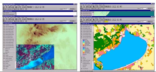
Figure 1
Some quick views on ECM ArcView project file
- A satellite image theme covers
the majority of the pilot area. Involvment of
further remotely sensed data was hindered due to
their high cost. Actually, land cover information
of (CORINE; see later) is also based on satellite
imagery.
- Information on soil is
represented by the polygon theme AGROTOPO.
AGROTOPO is a soil information system on
Hungarian soils in a scale of 1:100.000. Its
mapping units (agroecological units) are
characterized with nine different attributes.
- Information on geology is also
represented by one theme. An expert system based
value characterizing the vulnerability of the
geological environment is involved in the ECM
methodology.
- Information on land cover is
also represented by one theme. Land cover
categories are given with a code of three digits
where the first two digits refer to two further,
higher level categorization of actual land cover.
- A raster was filled up by
local municipal experts. Environmental impact
categories were determined upon the experience of
EU and Hungarian studies but considering the
Sofia priorities and the 5th Environmental Action
Program as well. Moreover, they indicated
conflicting land use schemes occurring in their
area and made a summary of the major problems
occupying them. The specified criteria (namely 15
different factors) were to be classified and
indicated by the municipalities for each cell of
the raster on a scale ranging between 0-4. The
spatial resolution of the raster is 500x500
meters inside settlements and 1000x1000 meters
around settlements. This local knowledge based
information is shared in four individual themes.
Data were provided for settlements and outer
regions for low and high (touristic) season.
- TIC data involves two kind of
information:
- sub-catchments of Lake Balaton
as a polygon theme without any important
attribute furthermore only three of them are
touched by the pilot area.
- potential and/or actual
polluter sites within pilot area as a point theme
with a huge number of descriptive data, which
includes detailed information on industrial and
communal waste depositories, 75 are lying inside
the pilot area.
ECM ArcView project collects all
relevant and available data for Balaton pilot area in one
session. In one hand this project is highly suitable for
computer demonstrations of the data collection
activities, on the other hand it also represents the
starting point of any spatial analysis carried out based
on the ECM database in order to achive ECM’s.
SAMPLE ECMs
Sample ECMs are stored in various
ArcView project files. These files originate from ECM
project file. They are supported with ArcView extension:
Spatial Analyst for the execution of spatial analysis.
Unrelevant data layers are deleted, new themes created
either as auxiliary themes or ECM results. A final
softcopy map as a layout is always compiled.
1. Groundwater vulnerability under
TIC censused sites
The vulnerability of the geological environment is of
outstanding importance in accelerating or preventing the
progress of pollution in groundwater and deep subsurface
water horizons. The various geological factors determine
the capacity of preventing the migration of pollution
into subsurface water tables. TICs are responsible to
collect information on pollutants/potential pollutants:
location, ownership, cadaster emission data, amount of
processed and produced hazardous waste, site and state of
communal waste depositories. Potential and/or actual
polluters situated over locations with higher hazard of
pollution vulnerability should be treated/checked more
seriously. Consequently, a co-evaulation, spatial
analysis of the conflicting environmental factors should
be carried out to get a complex picture on groundwater
vulnerability endangered by TIC censused sites.
An expert system based methodology of pollution
vulnerability assessment subdivides the considered area
into 4 classes according to the combination of three
geological factors High, medium and low vulnerability
classes are defined considering the capacity of
preventing the migration of pollution. TIC censused sites
were categorized according to their profiles into two
groupes: sites producing or not hazardous waste with risk
to subsurface water tables. Sites belonging to the former
class then were further classified according to their
geographical location within the various geology based
vulnerability categories. Sites are ranked as ones with
high, low or no hazard of subsurface pollution. The
output ECM entitled ‘Groundwater vulnerability under
TIC censused sites’ is displayed in Fig. 2.
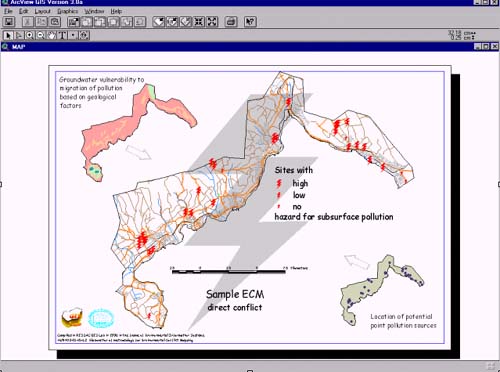
Figure 2
Sample ECM: Groundwater vulnerability under TIC censused
sites
2. Impact of traffic on Natural
Conservation
Territory of Balaton National Park covers major part of
northern Balaton region, consequently there is high
overlap with the present ECM pilot area. Balaton region
is also characterized as tourist attraction which
requires infrustructural background: road and railway
network. Noise and pollution of the traffic network
conflicts with the functions of National Park, parts of
National Park close to elements of traffic network are
less valuable and strongly exposed to damages than
farther areas. The co-evaulation, spatial analysis of the
conflicting environmental factors gives a complex picture
on status of Balaton National Park endangered by traffic
caused impacts.
Impact of environmental elements represented as line
features was modelled using buffering techniques.
Buffering generally means creating a polygon around
spatial objects with a given radius. Spatial Analyst
modul of ArcView however provided a more sophisticated
opportunity. According to the distance of the elements of
a grid from a spatial unit grid, cells were classified;
thus the whole territory was characterized with one
operation. Co-evaulation of buffer zones resulting from
railway and road system and further merging with spatial
extension of National Park then provided vulnerability
classification of Balaton National Park. The output ECM
entitled ‘Impact of traffic on Natural
Conservation’ is displayed in Fig. 3.
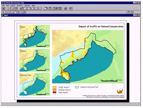
Figure 3
Sample ECM: Impact of traffic on Natural Conservation
3. Overall perception on state of
local environment
Simultaneous environmental impacts sum up in overall
perception on state of environment in human mind. Too
much load results in bad perception, which is a conflict
in itself. This situation can be treated as a
‘polarized’ conflict where is no other
component, but any, even the slightest, potential
negative change in state of environment results in real
conflicts. Highly impacted sites are
‘preconflict’ areas.
Values for specific environmental elements provided by
municipalities for pilot area raster were summed up.
Since high value for a given factor means bad feeling on
state of environment, higher the summed up value the more
the environmental impact within a given raster cell.
Actually, summarizing category values representing as
different factors involved in data collection can be
judged at the first sight. Nevertheless overthinking the
procedure it can be concluded that the result does give
an indication about the state of local environment. The
output ECM entitled ‘Overall perception on state of
local environment’ is displayed in Fig. 4.
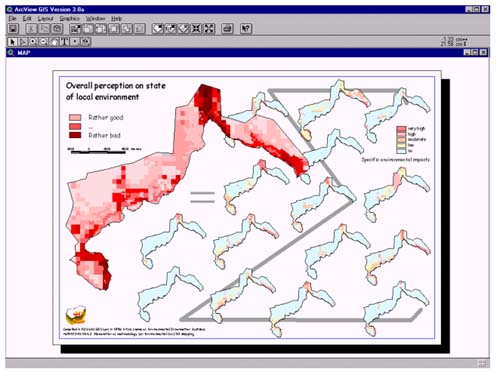
Figure 4
Sample ECM: Overall perception on state of local
environment
ACKNOWLEDGEMENT
Present work was carried out in the
frame of PHARE project No. HU 9402-01-01-L2. Authors are
grateful to the Ministry of Environment and Regional
Policy and Environmental Protection and Thematic
Information Center at Székesfehérvár for their
technical assistance. Special thanks to Zsófia Bakacsi,
Zsuzsanna Flachner, Kálmán Rajkai and Balázs Zágoni.
|


