Marco Mondini
Provincia di Bologna, Via Zamboni 13, 40126
Bologna, tel (+39) 051218518, fax (+39) 051218524, mondini@provincia.bologna.itEmanuela Cova
Provincia di Bologna, Via Zamboni 8, 40126
Bologna, tel (+39) 051218812, fax (+39) 051218810, manu@metro.provincia.bologna.it
Abstract
The Province of
Bologna is a local authority whose extension covers an
area of about 3300 Kmq, inhabited by one million people.
Its main duty concerns land programming and urban
planning. Since 1987, the Province has been creating and
maintaining its own GIS data sets, aimed to describing
the whole provincial territory and the urban and
territorial plans. Furthermore, instruments for
consultation and elaboration have been acquired based on
ArcInfo GIS.
For internal use
purposes and then as a tool for the description of GIS
data for sale, a metadata application has been
implemented, following the European directives based on
CEN/TC287.
Recently, new
telematic technologies have been developed in order to
improve communication and data exchange between the
Province and other local authorities, such as
Municipalities.
Lastly an
agreement with Cadastral offices has been signed,
allowing the Province to manage the overall cadastral
geographical data set.
By considering
all these aspects and the high availability of
geographical information, the Province of Bologna has
been involved into the EU Research Project Commuter,
aimed at developing software and methods to support
update and integration of GIS data and transactions that
can be executed by remote distributed databases.
Significant tests on new geographical cadastral data
updating procedures will be led, based upon spread
interfaces and integration between cadastral and
territorial geographical data sets.
This paper
describes the main characteristics of the Province of
Bologna activities in GIS sector, focusing on Commuter
Project with particular reference to the Italian
prototype.
1. INTRODUCTION TO THE PROVINCE
OF BOLOGNA AND ITS ACTIVITIES
The Province of Bologna is a
local authority, which administers an area of about
350.000 hectares and it is inhabited by one million
people approximately. It is one of the nine Provinces
of the Emilia-Romagna Region. The Province is
articulated into Sectors, Services and Offices. The
Land Planning Sector is directly involved into the
Commuter Project and represents one of the main
activity areas of the Province.
The provincial territory is
administered locally by sixty Municipalities, first
of them Bologna, which differ greatly in extension
and number of inhabitants. The Province is
responsible for the government of the whole territory
and co-ordinates the municipal activities.
The main duties of the
Province, with particular reference to the above
mentioned area, are land programming and planning,
environment, water and soil control and protection.
Besides it is responsible for further functions
concerning master plans control in order to verify
the congruence with the general territorial planning.
According to recent legislation, the Province
co-ordinates also the activities of data collecting
and processing of other local authorities, such as
Municipalities, Mountain Communities, Consortia, etc.
2. PROVINCE'S GIS AND DATA SET
DESCRIPTION
2.1 INTRODUCTION OF GIS INTO
THE organisation
The activity of the Land
Planning Sector concerning territorial information
systems begun in 1987 and grew up thanks to some
important laws which contributed to define the role
of the Province in the design and the management of
GIS: L.R. 30/1988 (designing of the Emilia-Romagna
Region's Information System), L. 142/1990 (reform of
local authorities), L.R. 6/1995 (rules concerning
territorial programming and planning).
The Land Planning Sector has
its own data transmission network dedicated to the
Territorial Information System (SIT) for planning
purposes. The available data have been acquired by
Emilia-Romagna Region or thanks to agreements with
other Institutions such as the Municipality of
Bologna, ATC (Public Transport), SEABO (Energy and
Environment).
A strongest incentive to the
development of the provincial SIT is due also to
administrative aims: thanks to information
technologies the urban master plans control has been
facilitated. Furthermore, urban master plans and
cadastral data form a fundamental data set at a
municipal level and their computerisation leads to
simplify many administrative procedures.
2.2 GIS HW AND SW
INFRASTRUCTURE
By considering also the
metropolitan offices, the provincial SIT (fig. 1) is
formed by four UNIX Sun servers and seven ArcInfo
licences, by two NT servers for the management of
Intranet/Internet services, by fifteen clients and
about ten ArcView licences for GIS data consultation,
by two A0 digitizers, two A0 ink-jet plotters, three
networking laser printers and three networking colour
ink-jet printers. At the moment, the metropolitan
offices are connected by means of a 2 Mbps
radio-bridge.
Figure 1
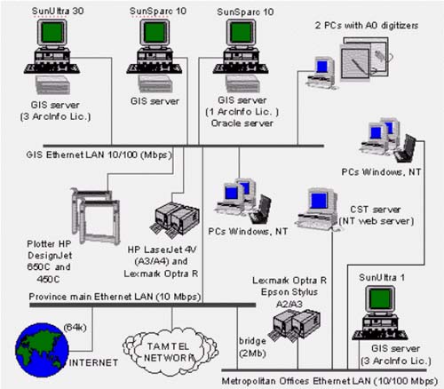
Scheme of the provincial SIT
2.3 DATA SETS
The Province and, in
particular, the Land Planning Sector manages a number
of geo-related data. The most important layers,
covering the whole provincial territory and acquired
at a scale among 1:25000 and 1:5000, are:
administrative boundaries, settlement boundaries,
water flows, rivers' respect zones, lakes, water
basins, alluvial terraces, roads and railways (fig.
2), drain networks, high-voltage electric lines,
census tracts, regional landscape plan, some tables
of PTI (the provincial master plan), dumps, municipal
master plan zones, real land use, raster topographic
maps of the province (scale 1: 5000 and 1:25000 at a
resolution of 800, 400, 200 dot per inch).
Figure 2
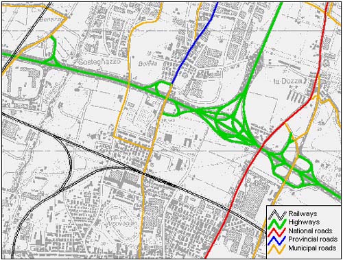
Roads and railways on a raster base (scale 1:25000)
2.4 METADATA
In order to archive and easily
retrieve all the information about the geo-data, the
Province began to store them into a structured
meta-database. The CEN/TC287 European standard has
been chosen, in order to be as much as possible open
and compliant towards the emerging standards.
Figure 3 shows the main window
of the developed meta-database showing the general
description of the transport infrastructure dataset,
containing information about roads and railways of
the provincial territory. This input mask allows to
enter other important sections, such as the quality
of the dataset, the reference system used during the
acquisition and the extended description of the
spatial objects. All these information allow users to
have a general and complete overview of data they are
interested in. The contents of the meta database will
be organised in an Oracle DB, in order to obtain a
more efficient and shared consultation.
Figure 3
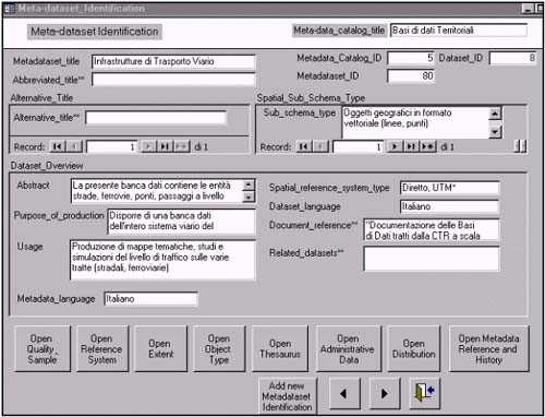
This figure shows the main input mask of the
meta-database.
It concerns the general description of the road and
railway system of the Province of Bologna.
3. GIS-RELATED PROJECT
3.1 AN IMPORTANT AGREEMENT FOR
ACQUIRING CARTOGRAPHY
In 1995 an agreement between
the Region, Municipality and Province of Bologna, ATC
and SEABO has been signed, which aims at creating,
maintaining and enlarging a cartographic database for
the management of any initiative related to the
territory. During 1997 also COSEA (Consortium of
services) signed the agreement.
The main purpose of this
agreement is the creation of cartographic instruments
for a shared GIS on the provincial territory and for
the definition of methods and rules for exchanging
data.
Following the guidelines of the
agreement, cartography will be available also to
private and public users. The access to the
informative data bases and the sale methods will be
defined following national and community's rules.
3.2 ACHIEVED RESULTS
A numeric cartography (scale
1:5000) has been realised, based on the regional
technical cartography derived by aero-photogrammetric
techniques, which represents one intermediate
instrument able to satisfy the different
requirements: the computerisation of this
cartographic base (raster format) forms a fundamental
working instrument for the present activity and also
for the next acquisitions. Another cartography has
been also realised (scale 1:25000) for
representations at a lower detail.
The second task has been the
completion of the road network model of the whole
provincial territory: the first release has been
produced by the Region and the Province by means of
the acquisition of the road axes in vector format
starting from the raster base (scale 1:5000) and the
integration of the information collected by the
toponomastic census.
In particular this instrument
allows to manage and localise networks and
technological systems for managing the distribution
of water and gas, trash collecting points, bus stops
and routes, maintenance operations of public
infrastructures, business and productive activities,
information on the population, local fiscality.
The operative program is to be
defined, related to the future activity and to the
economic plan for the next three years due to the
renewal of the agreement. The first step will be the
acquisition of the civic numbers of the whole
provincial territory: in this way, every object
referred to an address will be easily retrieved.
The costs of the projects have
been subdivided between the partners according to
their interest and to their involvement. The raster
cartography (scale 1:5000) cost 170 million ITL; the
acquisition of the graphical road network cost 180
million ITL.
3.2 TAMTEL
In order to improve the
communication inside the Public Administration, the
Province planned to create a telematic infrastructure
in order to be connected to the 60 municipalities
forming the provincial territory.
Instruments for
telecommunication will be purchased for the creation
of dedicated ISDN or Frame Relay lines between the
Province and some Municipalities which will be the
reference point for the surrounding smaller ones.
This project will allow different services also based
on cartography.
Figure 4 represents the network
scheme.
Figure 4
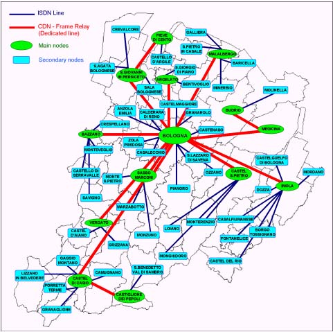
TAMTEL network
3.3 AGREEMENT WITH CADASTRAL
ADMINISTRATION
Cadastral cartography has
always been an important informative base for the
description of the territory useful for land planning
and as an instrument for local fiscal control.
Recently Province of Bologna,
Emilia-Romagna Region, Municipalities of Bologna and
Imola and Cadastral Office of Bologna (UTE) signed a
10-year agreement aimed at updating all the arrears
of the cadastral terrain database (about 44000
dossiers). This database will be available to the
partners for the whole period. In this way, the
Province of Bologna will be able to serve its
Municipalities giving them, for internal use only, a
copy of the cadastral data.
In order to use cadastral data
into its GIS, the Province equipped with a data
conversion system which allows different conversion
levels on different operative systems.
The process is described in
fig. 5.
Figure 5
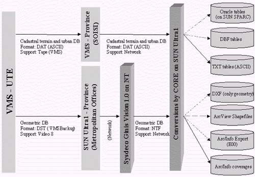
Cadastral data conversion system towards ArcInfo
language. Dashed arrows indicate an optional
conversion. Conversion modules are produced by
Sysdeco Italia on NT and by CORE on UNIX.
4 . COMMUTER PROJECT
4.1 GENERAL FEATURES
Commuter project is part of the
Esprit programme aimed at promoting research and
development activities in the field of advanced
information technologies. The main aim of the project
is the development of a system which supports
management and updating of geo-data used by public
administrations and, nowadays, spread on different
departmental databases and systems.
Geo-referenced data, used for
providing services and for accomplishing
institutional tasks, need to be continuously updated,
controlled and validated. Therefore, Commuter project
aims at developing software and methods to support
update and integration of geo-data and transactions
executable by remotely distributed data bases. The
expected result is an infrastructure which allows, by
means of information technologies, updating of
geo-data in various institutional contexts which
differ according to national applications.
4.2 ITALIAN PILOT APPLICATION
With particular reference to
the Italian context, Commuter aims at equipping
Public Administrations with multimedia tools, in
order to simplify the management and the processing
of cadastral data. It allows to acquire data and
information for cadastral estate management and
future planning purposes, to access methods for
updating cartographic and semantic data, to improve
data exchanging between different organisations. The
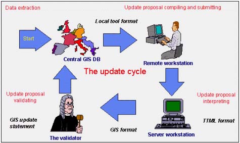
main innovation of the project is the possibility to
propose a directly executable updating of cadastral
data (fig. 6a) from a remote site located in the
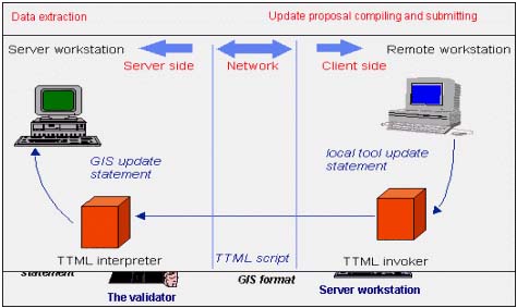
Municipalities: Commuter includes a geographic data
updating language, TTML (fig. 6b).
Figure 6a
The update cycle. From a remote workstation, end-users
can perform an updating proposal which will be submitted
to the validator: if the request is accepted, the Central
GIS DB will be updated.
Figure 6b
The Transformation and Transaction Management
Language (TTML).
The system (fig. 7) is
constituted by a Territorial Service Centre (TSC)
where a copy of all data regarding the four
municipalities, either cadastral and territorial, is
stored. This TSC is the computer server of the
Intranet which will be constituted by four computer
clients located into the Municipalities. The
communication infrastructure (TLC) will be of direct
or ISDN type at 64 Kbps with TCP/IP communication
protocol.
Figure 7
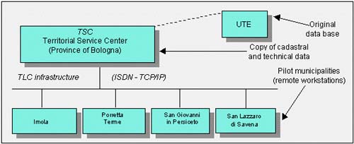
Logical architecture of the system for the Italian
application.
4.3 THE PROTOTIPE
A prototype of the Italian
application has been already developed by Olivetti
Ricerca, the technical partner, and will be soon
available at the Internet address http://cst.provincia.bologna.it (fig. 8).
Figure 8
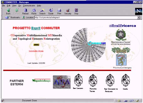
Homepage of Commuter prototype.
At the moment the prototype
allows to get three kinds of certificates:
"visura", "estratto" and
"destinazione urbanistica".
"Visura mappa" is a
cadastral certificate representing the properties
description of a company inside the Municipal
boundaries; "estratto mappa" is a part of a
cadastral sheet representing the parcel;
"destinazione urbanistica" shows the town
planning purposes belonging to the parcels required
by the user.
Another section concerns the
update proposal upon the databases, either
cartographic or alphanumeric. This part is still to
be enhanced.
5. CONCLUSION
The pilot application for the
cadastral case in Italy, defined in Commuter, aims at
defining and evaluating a new technological support
framework in order to handle the exchange of legal
data between Cadastral Office and Municipalities.
Furthermore, the fiscal policy of remotising tax
collection is of great importance, since the
cadastral archive is the basic reference to any
taxation process. The area of Bologna was selected
for the experimentation of Commuter because of the
high level of experience in managing cartographic
data and for the good quality of cadastral and
territorial data at provincial level. Four
Municipalities surrounding Bologna will be linked to
a telematic pole located in a service centre where
the staff of the Province together with the cadastral
officers will supervise the entire process. The
communication infrastructure is based upon a fast
digital data transmission network, where ad hoc
templates of real data sets will be open to different
users.
REFERENCES
- AA.VV. (1993),
"Progetto Territorio – Il Sistema
Informativo Territoriale della Provincia di
Bologna", PTI Provincia di Bologna,
Bologna.
- P. Cupido (1995),
"Progetto Territorio - Il Catasto e la
Cartografia numerica", PTI Provincia di
Bologna e Universita' di Bologna, Bologna.
- A. Durazzi (1994),
"Progetto Territorio – La
diffusione dei Sistemi Informativi Geografici
in Europa: il caso delle aree metropolitane
di media e grande dimensione", PTI
Provincia di Bologna e UniversitÓ di
Bologna, Bologna.
- M. Mondini, E. Cova
(1998), "Commuter Project – An
overview of the Italian application", in
Proceedings of the 4th EC-GIS
Workshop, in press.
|


