Using GIS to Inventory Shallow Habitat within a Dynamic Floodplain Wetland Complex
Ellen Ehrhardt
Abstract
In order to begin to assess the influence of the spring flood hydrology on habitat dynamics on the Missouri River flood plain, we studied spatial and temporal distributions of waterbirds in relation to distribution of water and shallow water habitat (1999). A grid of the distribution of shallow water and water coverage was developed with ArcInfo/GRID. Based on two elevational control points on the river, a water surface with a constant slope was determined by iterative COSTDISTANCE calculations. Water coverage was then estimated by intersecting the assumed water surface with the topography. The CUTFILL function was used to estimate shallow habitat. The LATTICESPOT function was used to gather test points to evaluate the model. Area of shallow habitat and other morphometric measures were output as potential explanatory variables in the statistical analysis of waterbird distribution.
The Missouri River is one of the largest alluvial rivers in the world and has been under man's influence since modern settlement. Today, restoration of some of the
floodplain functions seems a rational and socially efficient way to truly make the Missouri River a river of many uses, from water supply, to recreation, to fish and wildlife
conservation. GIS and other technologies of today provide a means of estimating characteristics of the restored habitat over large expanses of terrain and channel. A
model under development will allow conservationists and engineers to view the floodplain under theorized and realized hydrographs and to estimate the habitat under
each scenario. With this tool they will be able to make better decisions with regard to land purchases and river level management. This first cut of the model is a physical
replication of the shallow habitat provided at given discharges based solely on elevation. The pilot study conducted in the spring of 1999, attempts to establish a
relationship among depth and duration of inundation and two biological responses: invertebrate density and waterbird use. This paper evaluates the feasibility of the use
of the physical modeling technique for quantifying floodplain habitat.
Living with an Altered River
Political pressures to alter the Missouri River to support an inland waterway for transportation and commerce were created as early as the mid-19th century (Schneiders
1999). Channelization of the Missouri River in support of navigation began in earnest in the early 20th century and added emphasis in flood control with the Pick-Sloan
Act of 1944. The Pick-Sloan Missouri Basin Program was a basin-wide plan to provide flood control, irrigation, navigation, recreation, preservation and enhancement
of fish and wildlife habitat, and power generation on the Missouri River, with clear emphasis on commercial uses of the river and flood abatement (Hesse et al. 1989). A
series of legislation lead to the construction of reservoirs on the Missouri River to support irrigation for the upper basin and maintenance of a 9-foot navigation channel
for barges, and construction of levees to abate flooding on the lower river. A century of channelization and levee construction has transformed the Lower Missouri River
from a meandering, shifting, dynamic channel to a highly confined conveyance (Funk and Robinson 1974).
The significance of these alterations were dramatically demonstrated in 1993 when a period of sustained rainfall resulted in extensive flooding of the Lower River. Peak
discharges during this period were measured as high as 750,000 cfs at Herman, MO (Parret et al. 1993). The high discharge and sustained flooding resulted in the loss
of numerous levees and extensive flooding of the Lower Missouri River floodplain. The hydrologic forces in this flood led to enormous property losses and thick
deposits of sands in agricultural fields.
The extent of property damage, sand deposition, and loss of farm income led to a comprehensive re-evaluation of the problems of preventing floods in such a large,
dynamic river system and how the government was dealing with them (SAST 1994). Following the flood of 1995, it became apparent to flood-review commissions that
the previous system of levees was insufficient to control flooding of the Lower River; but management corrections varied widely depending on one's social, economic,
and natural resource perspective, ranging from building the levees higher to opening additional floodplain to the river to attenuate flood crests.
One management solution to flooding was acquisition of flood-damaged properties by natural resource agencies. These acquisitions served many purposes including
expansion of flood storage volume, and floodplain habitat, and improvement of habitat for numerous riverine fishes and wildlife resources by allowing the river to
reconnect with the floodplain where feasible. State and federal agencies assisted with land purchases. For the U.S. Army Corps of Engineers (COE) it helped fulfill their
responsibility to mitigate for fish and wildlife habitat lost during reservoir construction and channelization. This was required because the National Environmental Policy
Act was made effective on all unfinished projects at its signing in 1969.
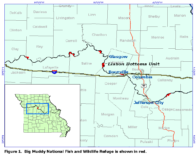
One of the acquisition programs established the Big Muddy National Fish and Wildlife Refuge (Big Muddy Refuge) in 1996. The concept of Big Muddy Refuge was a
string of distinct land parcels distributed longitudinally along the river corridor -- thus coined a "String of Pearls" by the first refuge manager J.C. Bryant -- referring to the
spatial distribution of the parcels and perceived value of Big Muddy Refuge's fish and wildlife resources ( Fig. 1 ). It is also the first and only refuge designated to meet
needs of fish.
Coincident with emergency management of flood prone lands, the Missouri River Master Water Control Manual (Master Manual) had been opened for public review in
1989 and the Draft Environmental Impact Statement was issued in 1994. The Master Manual guides the COE to decide the appropriate water levels in each of the
main-stem reservoirs. Although the original intents of river management were to support agriculture in the "bread-basket of America", agricultural irrigation and barge
navigation have never met expectations (Schneiders 1999). Moreover, the litigating parties influencing river management has evolved: in the upper basin, management of
the reservoirs has changed from agricultural irrigation to recreation, and on the lower river-- from navigation to fish, wildlife, and recreation, though this evolution has
been contentious, and is far from resolved. The leveling and stabilizing of the hydrograph has possibly had the greatest negative impact on species richness (Galat and
Lipkin 1999).
Consideration of fish and wildlife values has included reflection on optimum management of wetland ecosystems. This involves basic understanding of the frequency,
duration, and timing of flooding events in relation to life cycles of breeding riverine fish species and breeding and migrating waterbirds (Ehrhardt 1996, Galat et al. 1998),
and understanding of the structural composition of the habitat required and a means of identifying and quantifying each structural habitat (Humburg 2000, Ehrhardt
1996). This understanding is critical in formation of the Comprehensive Conservation Plan for the Big Muddy Refuge and current legal negotiations with the U.S. Army
Corps of Engineers ensuring that river management maintains habitat for endangered species. As more agencies require accountability for fish and wildlife habitat, a
general need exists for estimating aquatic habitat over vaste areas, and specific need for (1) definition of habitats used by fish and wildlife, (2) quantification of habitat
provided over theorized hydrographs as well as realized hydrographs, and (3) a need for understanding the functioning of floodplain habitats for fish and waterbirds.
Waterbird Floodplain Ecology
Waterbird response to floodplain habitats is complex, but the salient factors are depth, duration, and timing of availability of habitat. High mobility allows waterbirds to
exploit wetlands across large geographic areas because the birds move long distances and are adept at locating suitable habitats where and when they occur. In large
floodplain rivers, wetlands of similar morphometry and timing of connection with the river are located in particular reaches and locations on the floodplain (Bigras 1990).
The frequency and duration of connection with the river increase the productivity of floodplain wetland habitats (Knowlton and Jones 1997). The most frequently
connected wetlands tend to be at the junctures of rivers and tend to be shallow. Basin morphology influences the availability of invertebrate prey in these dynamic
systems and waterfowl shift their use of lotic and lentic habitats in response to changing water levels (DeBruyckere 1988). Waterbird species select specific depths and
distribute among wetlands in relation to availability of water depth and hydrologic state. Waterbird response to depth has been studied in the past as percent of filling
(Heitmeyer 1986, Humburg 2000), also in relation to lake morphometry (DesGranges and Darveau 1985), and as direct depth measurements (Taylor 1977). The extent
of a wetland that is 0 - 2 feet deep is strongly correlated with use of riparian wetlands by ducks (Brubaker and Witmer 1989). Thus location and condition of habitat
within a riparian system is predictable within a "window in time", and waterbird abundance and community composition reflect wetland morphometry and hydrologic
state.
In a floodplain wetland, invertebrate habitats are periodically disturbed. This influences the availability of invertebrate prey to waterbirds despite favorable foraging depth
conditions. On the other hand, invertebrates may become wind-rowed during flooding and hence more available. Later as waters recede, just as wetlands become
isolated from each other, juvenile fish become highly concentrated. The latter window happens to coincide with fledging of great blue herons (Chapman and Ehrhardt
1997, Ehrhardt 1996, See also Butler 1994). Waterbirds find these short-lived conditions aided by hydrologic events that are predictable in time and location within the
landscape (Junk et al. 1989). The predictability of habitat in time and space on the floodplain should allow for assessment of habitat quality, quantity, and prediction of
waterbird use as well.
The "depth-inventory" procedure outlined here combines two grids - a river/water surface grid and a topographic/bathymetric land grid to demonstrate and quantify the
distribution of shallow water habitat on the floodplain. It builds upon the Iterative-Slope procedure that was developed to estimate water elevation surfaces using a
minimum of field determined water-surface elevations and the cost-distance function in ArcInfo/GRID in which bathymetric data were merged with a grid of a digital
elevation model (DEM) to compile an elevation grid for the river corridor, floodplain and channel (Ehrhardt et al. 1999,
http://proceedings.Esri.com/library/userconf/proc99/proceed/papers/pap382/p382.htm). The purpose of this report is to evaluate the extension of the Iterative-Slope concept
over the floodplain as a means of developing a rapid estimation of shallow habitat. The process of data manipulation required to produce the habitat data from the
modeled floodplain and water surfaces is described and evaluated.
Methods
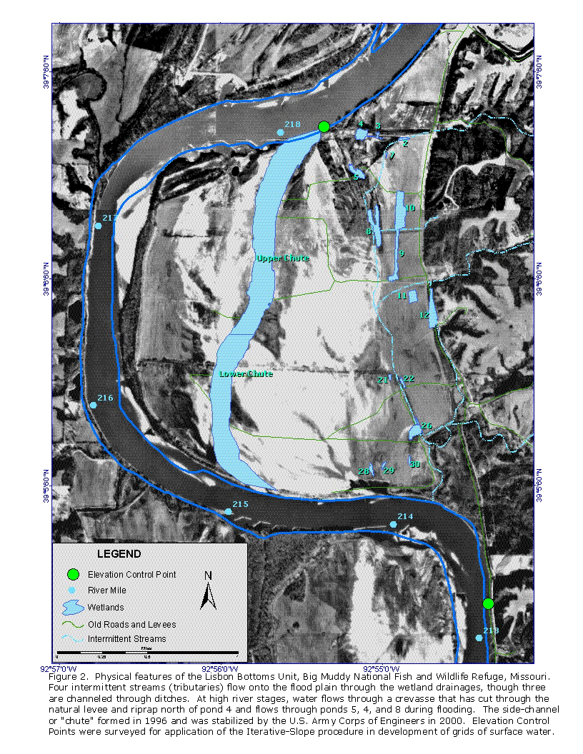
The study site is the Lisbon Bottoms Unit of the Big Muddy National Fish and Wildlife Refuge. It is unique among the 8 units of the Big Muddy National Fish and
Wildlife Refuge in that a side-channel (chute) formed in 1995. Overall, Lisbon has a complex of wetlands and scour holes fed by intermittent tributaries and fed by the
river during the spring rise (flood) ( Fig. 2 ).
Biological data were collected with geographic reference. Field surveys of waterbirds were conducted to document spatial and temporal distributions in relation to water
quality, invertebrate density and modeled amount of shallow water habitat. Waterbird surveys were conducted twice weekly from mid-March through May 1999.
Location of each group or individual waterbird on 12 wetlands was recorded as an offset from a staked point in a grid of stakes laid out in 6-meter intervals within the
wetland. Each stake location was recorded with a Global Positioning System (GPS) and later converted to a point coverage. On the chute, a rangefinder and compass
were used to record the distance and angle from a known (GPS) point location. Locations where invertebrate samples were taken were also recorded with a GPS.
Grids of the distribution of shallow water habitat on the floodplain throughout the spring hydrologic regime were created and used to reproduce the distribution of
shallow water and to estimate availability of shallow habitat. The modeled information was then compared to the empirical data to evaluate the feasibility of the
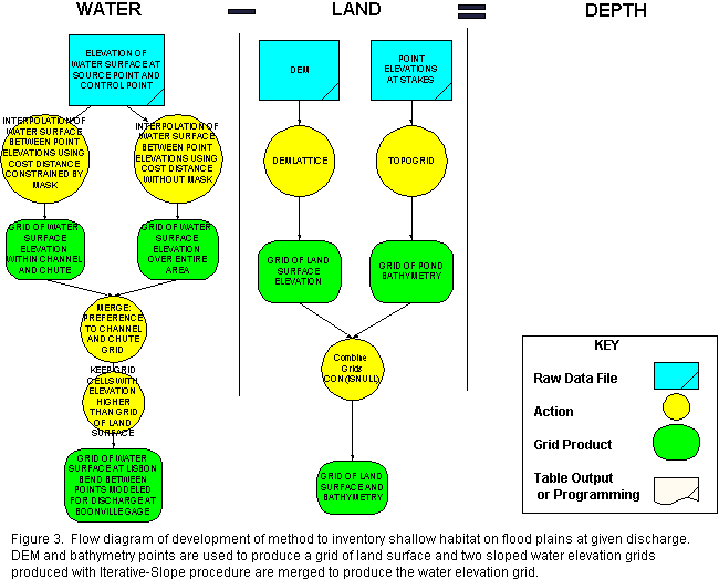
depth-inventory approach. First the land grid was updated to include bathymetry of wetlands and channels, and then sloped water surfaces were developed for each
sampling date ( Fig. 3 ). Water depth and morphometric measurements of the wetlands were obtained through the combination and analysis of the final water and land
grids. The "land grid" consists of the bathymetry of the wetlands, chute, river channel, and surface of the floodplain at the Lisbon bend. It was created by updating a
1994 USGS DEM with additional data we collected. Bathymetry measurements were collected in the river (Dec. 1997) and in the chute (June 1999) and added to a
grid of the 1994 USGS DEM using the Iterative-Slope procedure (Ehrhardt et al. 1999). Wetland bathymetric elevations were determined for 7 wetlands by surveying
the depth gages and converting depth measurements at staked points to elevations. Stake elevations for each wetland were converted to a grid with TOPOGRID with
vertical and horizontal tolerances of 0.0125 to 0.03125m. Wetland grids were merged into one grid. The grid of wetland bathymetry was then combined with the land
grid with the command combination: con ( isnull ( wetland bathymetry grid), land grid, wetland bathymetry grid). The final land grid was tested for sinks.
Next, a grid of the extent of water coverage was developed for each sample date. A grid representing the water surface over the floodplain and within the channel and
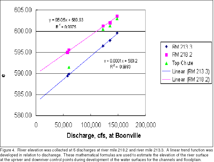
chute was created using the Iterative-Slope procedure. The surface water elevation at a point at RM 213.3 and a point at RM 218.2 were modeled over 5 discharges at
the Boonville gage on the Missouri River to establish a linear mathematical trend function ( Fig. 4 ). The modeled discharges ranged from approximately 50,000 cfs to
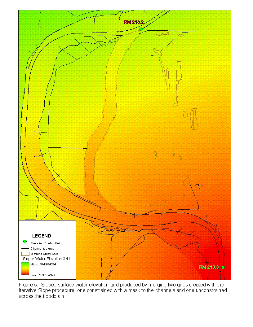
150,000 cfs; discharges in excess of 140,000 cfs inundate the floodplain. Two grids were produced applying the Iterative-Slope procedure between the two points; the
first was constrained to the channel and chute with a mask and the second was unconstrained over the floodplain. The two grids were merged (giving the grid of the river
channel-chute priority). This produces a representation of the water surface based on the modeling of water surface elevation at an upriver and a downriver point and
does not incorporate hydrologic concepts such as lag, groundwater, etc. found to be important in floodplain systems (Kelly 2001) ( Fig. 5 ). However, to allow for the
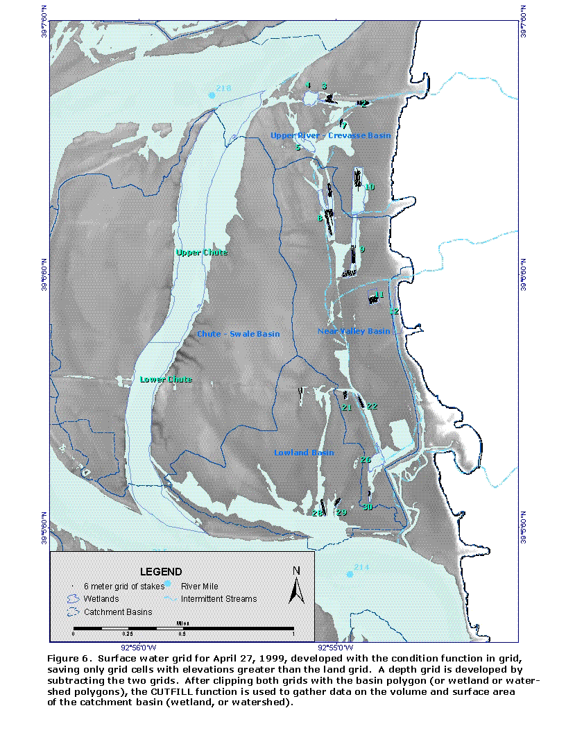
retention of water in wetlands, an additional grid was created of water levels in wetlands by assigning the elevations calculated from depth gage readings to a polygon
coverage of the wetland boundary and converting to a grid with the polygrid command. Two grids representing surface water levels was achieved by saving only grid
cells that were greater than the topographic-bathymetric grid ( Fig. 6 ). The two water surface grids were merged, giving the wetland water surface lower priority. Thus
water levels obtained from the depth gages would only occur if the depth-inventory procedure would have modeled the wetland as dry when data suggested otherwise.
In preparation for the application of the CUTFILL command, the water and topographic-bathymetric grids were clipped with wetland shoreline polygons (digitized at
the willow edge from aerial photography) as well as polygons delimiting watershed and catchment basins (developed with WATERSHED and BASIN commands in
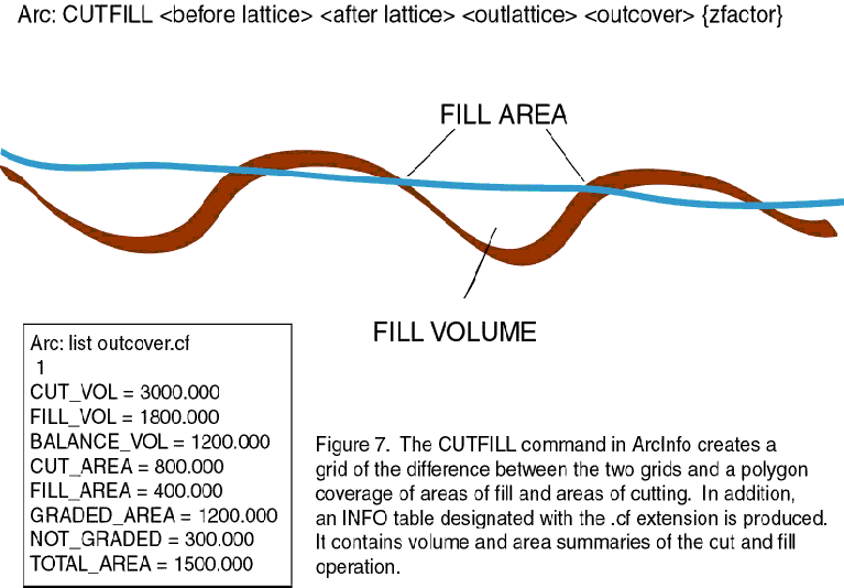
ArcInfo). The ArcInfo CUTFILL function is then used to provide summaries of surface area and volume. The CUTFILL function was originally developed for the
construction industry to assist with estimating cost of time for bulldozer equipment as well as fill requirements. The 3 outputs of the CUTFILL function include a grid, a
polygon coverage, and an INFO-file ( Fig. 7 ). The grid describes the difference between the "original terrain" and the "desired terrain". The polygon coverage
summarizes the volume of filled and cut areas within polygonal boundaries. The INFO file summarizes the volumes and areas of cut, filled, graded, and non-graded areas
for the entire project grid. In parallel to this analogy, the land-grid would represent the original terrain and the water grid would represent the desired terrain. The
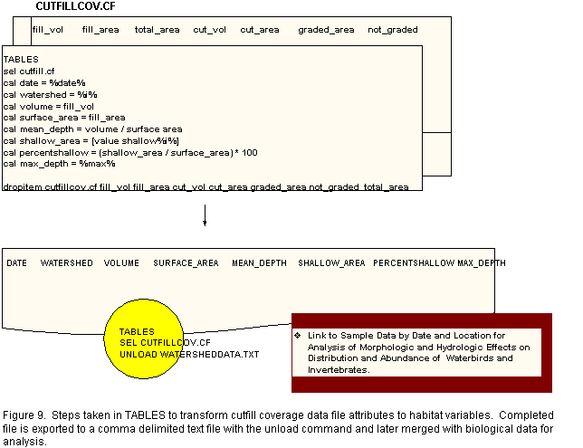
CUTFILL function then produces surface and volume summaries of depressions and islands. The INFO file was manipulated in ArcInfo TABLES to produce the
following morhpometric variables: surface area, volume, maximum depth, mean depth, percent shallow habitat, and area of shallow habitat ( Fig. 8 , Fig. 9 ). This was
accomplished for each watershed, catchment basin, and wetland. These variables are used to test relationships of shallow habitat with waterbird distribution.
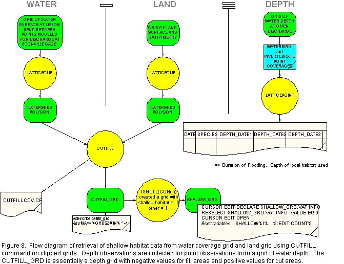
Subtraction of the water and topographic-bathymetric grids provides a grid of depth (depth grid = water grid - land surface elevation grid), providing a further
application of the model results. Histories of depth and duration of inundation of points sampled for invertebrates were gathered with the point coverage using the
ArcInfo LATTICESPOT command applied to depth grids for each day of survey ( Fig. 8 ). Similarly, depth and duration of flooding was collected for documented
locations where waterbirds were observed foraging.
Grid Refinements
While updating the land elevation grid with wetland bathymetry, a problem was encountered. Where ponds had silted in, it was not possible to collect depths on the
abandoned shoreline, furthermore, interpolation was tightly controlled and a depression around the perimeter became apparent. A mask of the sinks was created,
expanded 2 cells, and used as a mask to control filling. Sinks were filled with the FILL command. The mask was removed and the land elevation grid was updated with
the resultant new elevations with the GRID command combination: con(isnull(sink elevationn grid), land grid, sink elevation grid).
Evaluation Results
A weakness of the Depth-Inventory procedure is the reliance of multiple models upon each other. To evaluate water depth on the floodplain, this application of the procedure developed a model of depth based on another model of water surface, based on a mathematical model of water elevation laid over a highly modified grid of the land surface. Each modeled surface must be evaluated separately: the land elevation surface, the water surface, and the resulting depth surface.The water surface grid is actually two grids: the grid contrained to the channel and the unconstrained. The constrained water grid is evaluated using surface elevation and the grid unconstrained over the floodplain is evaluated using depth measurements.
Evaluation of Water Surface Grids over Chute
Four readings were available for one USGS depth gage placed in the chute and were considered in evaluation of the Iterative-slope procedure on the channel habitats. Modeled elevations were collected from water surfaces produced with the Iterative-Slope Procedure using the LATTICESPOT command in ArcInfo. Differences between modeled and measured water surface elevations were minor, ranging from -9.8 cm to 2.4 cm and were not significantly different (P=0.9619). Even though discharges modeled and evaluated over the chute (131,000 to 196,000 cfs), exceeded discharges used to develop the mathematical function for the control points, water surfaces modeled for the chute were similar to observed water elevations. There were no significant correlations among julian date, discharge, or difference detected (Pearson Correlation, alpha=0.05).
Evaluation of Water Surface Grids over the Floodplain
The adequacy of the model for recreating water levels over the floodplain was evaluated by comparing measured water depths with modeled water depths collected at
staked locations. Modeled water depths were collected from grids of water depth developed for each date that wetlands were measured, using the LATTICESPOT
command. The difference between the measured depth at each stake and the modeled depth at each stake on the date measured were tested using a signed statistic test
by wetland. This tested the hypothesis that the difference between the modeled depth and the measured depth is zero. Differences at the stakes were significant for all
but 2 of the wetlands (Table 1, alpha = 0.05).
Depth measurements were also collected at locations where invertebrates were sampled. Invertebrates were sampled from a subset of wetlands selected to represent a
continuum of hydrologic class (semi-permanent, seasonal, temporary) and were collected before and after but not during flooding. The points were typically clustered in
shallow habitat (< 30 cm deep). Invertebrate sample locations provided an independent source of point depth measurements for evaluation. Evaluation of the model with
the shallower invertebrate sample points supported the adequacy of the procedure (Table 2) whereas the data collected using the point coverage of stakes did not
(Table 1).
Table 1. Statistical description of the difference between the depths measured at stakes and the depths captured at the stakes by the model. A sign test for
non-symmetric distributions was used to test for the probability that the observed mean difference is a member of a population with a mean equal to zero. The units are
centimeters.
Wetland / Descriptive Statistic |
2 |
3 |
8 |
9 |
10 |
11 |
22 |
Number of stakes |
61 |
68 |
171 |
152 |
114 |
69 |
54 |
Mean Difference |
0.38 |
1.31 |
-32.32 |
1.99 |
-11.85 |
-1.34 |
-4.17 |
Standard Deviation |
1.793 |
3.329 |
24.963 |
4.193 |
9.421 |
2.738 |
6.745 |
Maximum |
7.7 |
15.7 |
36.9 |
22.8 |
5.1 |
2.1 |
15.8 |
Minimum |
-3.5 |
-3.5 |
-91.0 |
-13.7 |
-20.5 |
-11.0 |
-28.2 |
Coefficient ofVariation (%) |
4.75 |
2.53 |
-0.77 |
2.11 |
-0.79 |
-2.04 |
-1.61 |
| Probability of
a greater Sign Test Statistic |
0.6989 |
0.14207 |
0.00000 |
0.00000 |
0.00003 |
0.00354 |
0.00008 |
Table 2. Statistical description of the difference between the depths measured at invertebrate sample points and the depths captured at the invertebrate sample points
captured from the model. A sign test for non-symmetric distributions was used to test for the probability that the observed mean difference is a member of a population
with a mean equal to zero. The units are centimeters.
| Wetland
/ DescriptiveStatistic |
8 |
10 |
22 |
Number of samples |
6 | 3 | 8 |
Mean Difference |
13.57 | 3.67 | 8.90 |
Standard Deviation |
15.67 | 2.57 | 39.97 |
Maximum Difference |
36.0 | 5.3 | 60.7 |
Minimum Difference |
-1.2 | 0.7 | -29.0 |
Coefficient ofVariation (%) |
1.15 |
0.70 |
4.49 |
| Probability of a greater Sign Test Statistic | 0.3750 |
0.2500 |
0.7266 |
The depth-inventory procedure results were also evaluated for spatial and temporal correlation. The pattern of sampling is evident in the analysis of Pearson Correlation
coefficients: wetlands farther from the source point were measured earlier in the study, and river discharge fell during the period when depth was measured (Table 3). All
other Pearson Correlation Coefficients are not significant at the alpha=0.05 level.
Table 3. Pearson Correlation Coefficients among the difference between measured and modeled depths and date, discharge, and distance from the source point.
| Pearson Correlation
Coefficient
p-value |
Mean Difference | STD | Maximum Difference | Minimum Difference | Discharge |
| Standard Deviation | -0.9850
p=0.0003 |
1 | � | � | � |
| Maximum Difference | -0.6023
p=0.2058 |
0.7297
p=0.0997 |
1 | � | � |
| Minimum Difference | 0.9517
p=0.0034 |
-0.9785
p=0.0007 |
-0.7662
p=0.0756 |
1 | � |
| Discharge | 0.2363
p=0.6522 |
-0.3186
p=0.5383 |
-0.4970
p=0.3159 |
0.4322
p=0.3921 |
1 |
| Distance | -0.1199
p=0.8209 |
0.1024
p=0.8470 |
0.06315
p=0.9054 |
0.0172
p=0.9742 |
0.8051
p=0.0533 |
| Date | -0.6653
p=0.1493 |
0.6920
p=0.1277 |
0.5438
p=0.2648 |
-0.7811
p=0.0666 |
-0.8487
p=0.0326 |
Evaluation of the Updates to the Land Grid Elevations
After known errors were corrected, the elevations at the stake points were calculated based on the elevation of the depth gage and compared to the elevation of the
point on the updated land elevation grid. The wetland elevations at the points differ significantly from the original elevations that were used to create the grid (Table 4).
Although wetland 3 does not reject the null hypothesis, at least one minimum difference is undesirably large. The mean difference in the land grid elevations likely
represents a large portion of the error observed in the depth grid.
Table 4. The land grid was tested for accuracy by comparing the calculated elevations at the stakes to the elevations for the points on the land grid, thus wetlands modeled deeper than land surveys have a negative sign. The sign test was used to test whether the mean of the difference between modeled and calculated elevations equaled 0. The units are centimeters.
Wetland Descriptive Statistic |
2 |
3 |
8 |
9 |
10 |
11 |
22 |
Number of stakes |
61 |
68 |
171 |
152 |
114 |
69 |
54 |
Mean Difference |
-0.35 |
-1.30 |
-0.76 |
-2.65 |
-0.97 |
1.08 |
3.17 |
Standard Deviation |
1.79 |
3.36 |
3.83 |
5.75 |
1.21 |
2.67 |
6.13 |
Maximum |
3.6 |
3.5 |
10.2 |
3.0 |
1.0 |
10.7 |
12.7 |
Minimum |
-7.6 |
-16.5 |
-19.1 |
-40.4 |
-6.1 |
-7.1 |
-16.8 |
Coefficient of Variation (%) |
-5.15 |
-2.58 |
-5.05 |
-2.17 |
-1.25 |
2.48 |
1.93 |
Probability of a greater Sign Test Statistic |
0.6989 |
0.1421 |
0.7570 |
0.00000 |
0.00000 |
0.01034 |
0.00000 |
Waterbird Distribution in Relation to Shallow Habitat
The relative abundance of waterbirds during spring migration was found to be positively correlated with shallow habitat in the floodplain wetlands. Of all the waterbirds
observed on Lisbon Bottom during spring migration, the proportion observed on a sampling day was positively correlated with the surface area of water less than or
equal to 30 cm deep that was modeled in the wetlands (Spearman Correlation Coefficient R=0.22384, P=0.0310).
Summary and Conclusion
Dynamic hydrology encountered on the Missouri River floodplain during spring waterbird migration posed physical and conceptual challenges. One of the most
perplexing challenges was defining the study sample site. The dynamic nature of the land and hydrologic conditions do not lend themselves to traditional classification
design and survey. At times, ponds were well defined. Other times, the water rose and several ponds became one. Still other times, the "pond system" became a stream
or even the river.
The challenge of classifying a wetland into a hydrologic or size category or attempting to define its extent was addressed by applying GIS technology as described to
capture the dynamics of floodplain hydrology and the location of biological responses. Using GIS, we roughly defined geomorphic subdivisions of Lisbon Bottoms
described by Schmudde (1969) such as near valley, ridge-swale, and low valley using the WATERSHED and BASIN commands. These boundaries will be used in
assessment of habitat availability on the floodplain and waterbird response. The depth-inventory procedure provides a means of tracking information that would be
prohibitively labor-intensive.
Digital Elevation Models are of value to spatial modeling of habitat, but in a floodplain, DEMs become outdated rapidly. Updating the DEM-grid for this study was
important to develop the regression equations expressing the relationships among abundance and distribution of biota, shallow habitat, and duration of inundation.
However, updating the land surface grid was not satisfactorily accurate. Updating the land grid introduced several potential sources of error into the evaluation. Potential
sources of error include surveying the elevation of the depth gage, soft mud at the bottom of the wetlands during depth measurement, and errors reading depth gages.
Though soft mud up to 10 cm deep was observed during depth measurement, differences in the land grid were much greater. The error polygon for the surveying of the
gages in the northern ponds was closed at 0.05 feet of accuracy. Manipulations of the land grid were perhaps a greater source of error than the Iterative-Slope
procedure.
Despite the success of the water surface on the chute, extrapolation of the same mathematical function and tolerance condition over the floodplain did not produce as
reliable results. Depths were not accurately represented by the model at the stakes. Although the invertebrate point samples failed to reject that the differences of the
two depth estimates equal zero, this is likely due to the small number of samples and the clustering of the sample sites. Furthermore, invertebrate samples were collected
before and after the flood, but not during periods when water levels exceeded bank full, which was the case for the stake measurements.
Because of the errors in the land grid, the adequacy of the Depth-Inventory procedure across the floodplain could not be evaluated conclusively. The Iterative-Slope
procedure produced very reliable sloped water surface elevations for the chute over the 4 discharges for which the gage could be read.
The preliminary evaluation with conventional statistics has suggested that further analysis is needed on three points. First, the mathematical model to estimate the
elevation at the elevation control points needs to be modeled at discharges sufficient to inundate the floodplain. Perhaps historic information at gaging stations could be
used to infer a truer mathematical representation. Second, spatial accuracy is best assessed with spatial statistics due to the spatial correlation among sample points.
Spatial statistical tools available in Geostatistical Analyst will be used to estimate the error in the land grid and determine the amount of error inherited by the depth grid.
Third, keeping in mind that the ultimate goal is to be able to make habitat assessments based on information at hand, a parallel analysis should be conducted to determine
the relevance of the extra effort to update and evaluate the grid. These results should be compared with results from a parallel analysis with unmodified 1994 land and
water surfaces.
Literature Cited
Bigras, S. C. 1990. Hydrological regime of lakes in the MacKenzie Delta, Northwest Territories, Canada. Arctic and Alpine Research 22:163-174.
Brubaker, R. and D. Witmer. 1989. Waterfowl habitat use patterns on a four-square mile plot on Selawik National Wildlife Refuge, AK, 1988. Selawik NWR
Progress Report 89-4. U.S. Fish and Wildlife Service, Kotzebue, AK.
Butler, R. W. 1994. Population regulation of wading ciconiforme birds. Colonial Waterbirds 17:189-199.
Chapman, D. and E. A. Ehrhardt. 1997. unpublished data.
DeBruyckere, L. 1988. Feeding ecology of northern pintails (Anas acuta), American wigeon (Anas americana), and long-billed dowitchers (Limnodramas scolpaceous) on Selawik National Wildlife Refuge, Alaska. M.S. Thesis University of Maine. Orono, ME.
DesGranges, J.-L. and M. Darveau. 1985. Effect of lake acidity and morphometry on the distribution of aquatic birds in southern Quebec. Holarctic Ecology 8(3):181-190.
Ehrhardt, E. A. 1996. Abundance and distribution of waterbirds on 3 habitats of Missouri River floodplain following a major flood. M.S. Thesis. University of Missouri. Columbia, MO.
Ehrhardt, E. A., R. B. Jacobson, and A. J. DeLonay. 1999. Adding river bathymetry to floodplain topography for surface water modeling of the Missouri River. 19thEsri International User Conference. San Diego, CA.
Funk, J. L. and J. W. Robinson. 1974. Changes in the channel of the lower Missouri River and effects on fish and wildlife. Aquatic Series No. 11. Missouri Department
of Conservation. Jefferson City, MO.
Galat, D. L., L.H. Fredrickson, D. D. Humburg, K. J. Bataille, J. R. Bodie, J. Dohrenwend, G. T. Gelwicks, J.E. Havel, D. L. Helmers, J. B. Hooker, J.R. Jones, M.
F. Knowlton, J. Kubisiak, J. Mazourek, A. C. McColpin, R. B. Renken, and R. D. Semlitsch. 1998. Flooding to restore connectivity of regulated, large-river wetlands.
BioScience. 48(9):721-733.
Galat, D. L. and R. Lipkin. 1999. Characterizing the natural flow regime of the Missouri River using historical variability in hydrology. Final Report to Missouri
Department of Conservation. Columbia, MO.
Heitmeyer, M. E. 1986. Postbreeding distribution and habitat use of wading birds in Oklahoma, USA. Colonial Waterbirds 9:163-170.
Helmers D.L., D.D. Humburg, A.C. McColpin, E. Ehrhardt, J.A. Vogel, K.J. Bataille, L.H. Fredrickson. 1999. Chapter 5. Waterbirds. D.D. Humburg and V.J. Burke
(eds.) IN Initial Biotic Survey of the Lisbon Bottom, Big Muddy National Fish and Wildlife Refuge, Biol. Sci. Rep. USGS/BRD/BSR-2000-0001.
Hesse L. W., J. C. Schmulback,, J. M. Carr, K. D. Keenlyne, D. G. Unkenholz, J. W. Robinson, G. E. Mestl. 1989. Missouri River fishery resources in relation to
past, present and future stresses. Canadian Special Publication of Fisheries and Awuatic Sciences 106:352-371.
Humburg, D.D., K. Bataille, D.L. Helmers, D.A. Brunet. 1999. Study No. 18: Wetland Ecology Studies in the Missouri River Floodplain. Job No. 4: Evaluation of
seasonal habitat use by waterbirds on the Missouri River floodplain. Final Report. Researh and Survey Projects as required by Federal Aid in Wildlife Restoration Act
Missouri Federal Aid Project No. W-13-R-53(1999).
Junk, w. J., P. B. Bailey, R. E. Sparks. 1989. The flood pulse concept in river floodplain systems. P. 110-127 IN D. P. Dodge (eds.) Proceedings of the International
Large Rivers Symposium. Canadian special publication of Fisheries and Awuatic Sciences #106.
Kelly, B. P. 2001. Relations among river stage, rainfall, ground-water levels, and stage at two Missouri River flood-plain wetlands. Water-Resources Investigations
Report 01-xxxx. Rolla MO.
Knowlton, M. F. and J. R. Jones. 1997. Trophic status of Missouri River floodplain lakes in relation to basin type and connectivity. Wetlands 17(4):468-475.
Parret, C. N.B. Melcher, R. W. James Jr., 1993. Flood discharges in the upper Mississippi River basin. Denver (CO): u.S. Geological Survey. Circular no 1120-A.
SAST 1994. Sharing the challenge of floodplain management. A Blueprint for change Part V. Science for floodplain management into the 21st century.
Schmudde, T.H. 1963. Some aspects of land forms of the lower Missouri River floodplain. Annals of the Association of American Geographers. 53(1):60-73.
Schneiders, R. K. 1999. Unruly River: Two centuries of change along the Missouri. University Press of Kansas.
Taylor, T. S. 1977. Avian use of moist soil impoundments in southeastern MO. M.S. Thesis. University of Missouri. Columbia, MO, USA.
I would like to express my sincere gratitude to Dr. Dan Witter for editing the paper, as well as for his support and for being able to see the big picture. I would also like
to thank my supervisor Tony Spicci for allowing me the opportunity to gain experience with spatial statistics and the opportunity to complete the project. I would like to
thank Jim Fairchild for his contributions to the introduction of the paper and project management. I also appreciate the generosity of Steve Sheriff and Dr. Chris Waigel,
who made recommendations for statistical analyses.
Ellen Ehrhardt ehrhae@mail.conservation.state.mo.us