Introduction
The National Weather Service (NWS) provides weather, hydrologic, and
climate forecasts and warnings for the United States, its territories,
adjacent waters, and ocean areas, for the protection of life and property
and the enhancement of the national economy. NWS data and products form
a national information database and infrastructure which can be used by
other governmental agencies, the private sector, the public, and the global
community. The NWS meets its mission by providing warnings and forecasts
of hazardous weather, including thunderstorms, flooding, hurricanes, tornadoes,
winter weather, tsunamis, and climate events. The NWS is the official source
of warnings during life-threatening weather situations in the United States.
To more efficiently deliver its services, the NWS provides weather information to the public via the World Wide Web. On March 1, 2002, the NWS unveiled a new web design allowing easier access to forecasts and services. NWS is exploring the use of GIS as a tool to allow emergency managers to make better decisions. GIS is also used to provide its internal and external users with up-to-date background maps (in shapefile format) as various forecast zones change or are added, and when new products are added. The background maps are provided via the AWIPS Map Database Catalog (AMDC). NWS has also begun to explore the use of Internet Map Services as a means to convey its products to its internal and external users. This paper will explore the use of ArcView GIS and Esri's ArcIMS internet map server software as a means to experiment with this technology. The projects presented below are limited in scope in terms of the intended audience. They are designed for use by NWS to brief its senior management as well as management at the National Oceanic and Atmospheric Administration (NOAA) and the Department of Commerce (DOC) and, in the case of the river conditions data, a select group of emergency managers.
NWS Offices
The internet mapping tools were developed within the NWS by the Office of Science and Technology (OST), Systems Engineering Center (SEC), for the Office of Climate, Water, and Weather Services (OS )
The Office of Climate, Water, and Weather Services identifies customer requirements; oversees the delivery of hydrometeorological and climate services, and designs future products and services.
Within OS is the Awareness Branch. It provides guidance and creates materials to apprise customers and partners of NWS capabilities. The branch acts as the NWS point of contact for all Federal Response Plan issues. The branch is responsible for providing information to senior NWS, NOAA, DOC, and White House officials plus members of Congress on NWS services during extreme events. It is for this audience that the hurricane tracking website was designed.
Also within OS is the Hydrologic Services Branch, a part of which is the Hydrologic Information Center (HIC). The River Conditions web site was developed for the HIC. The HIC monitors hydrologic conditions nationally and provides summaries of flooding and other significant events for internal management and the public.
The Office of Hydrologic Development (OHD) is tasked with infusing new hydrologic science, developing hydrologic techniques for operational use, managing hydrologic development by NWS field offices, and providing advanced hydrologic products to meet needs identified by NWS customers; and it is also investigating internet mapping with an Internet Mapping Team. Within the U.S. are 13 River Forecast Centers (RFC) whose mission is "to save lives and decrease property damage by the issuance of flood warnings and river stage forecasts, to provide basic hydrologic forecast information for the Nation's economic well being and to provide extended forecast information for water resources management. As a part of this work, OHD formed a Water Resources Internet Mapping Team (WRIM) to investigate internet mapping. The cooperative precipitation website was developed for the West Gulf RFC at the request of the WRIM.
Hurricane Forecasts
Overview
Our system monitors hurricanes and tropical storms from their birth
till their death in the Atlantic and Caribbean basin, the Eastern Pacific
Ocean (from the west coast of the U.S. to 140 W), and the Central
Pacific Ocean from 140 W to 180 W. The Atlantic-Caribbean and Eastern
Pacific data are obtained from the National Hurricane Center, in Miami
FL, and the data for the Central Pacific comes from the Central Pacific
Hurricane Center (NHC). At this time, we are developing monitoring software
for the Western Pacific, for the area west of 180 degrees. These
data are obtained from the Joint Typhoon Warning Center. ArcView
3.2 is run via command line whenever new data are available. A project
containing Avenue scripts is used to create shapefiles for the output .
The latest input data are ingested by ArcView and the output is up to five
shapefiles for each active storm as well as a "static" jpeg which is zoomed
into each storm.
Input data
Forecast advisories are text
files obtained from the hurricane centers via http and ftp. The important
elements of the advisory are the issuing hurricane center, the date and
time of the advisory, the storm type and name, and the forecast data
table. At a minimum the table contains data for the initial
(current) position. Forecast data can appear for 12, 24, 36, 48,
and 72 hours out, although as few as one forecast point can be present.
Output data
The shapefile data created by ArcView are as follows:
Forecast Points: This is a point shapefile that contains
the current and forecast positions from the table. The first record
of the shapefile details the current information about the storm.
All fields are filled in this first record, which include the storm's type
(hurricane, tropical storm, or tropical depression), its name, the lat/lon
of the point's current position, maximum wind speed, and additional comments.
The remaining records contain information about the forecast positions
of the storm; only the lat/lon, time, and comments fields are populated.
.
Forecast Track: This shapefile is simply a line
connecting each forecast point with no additional attributes.
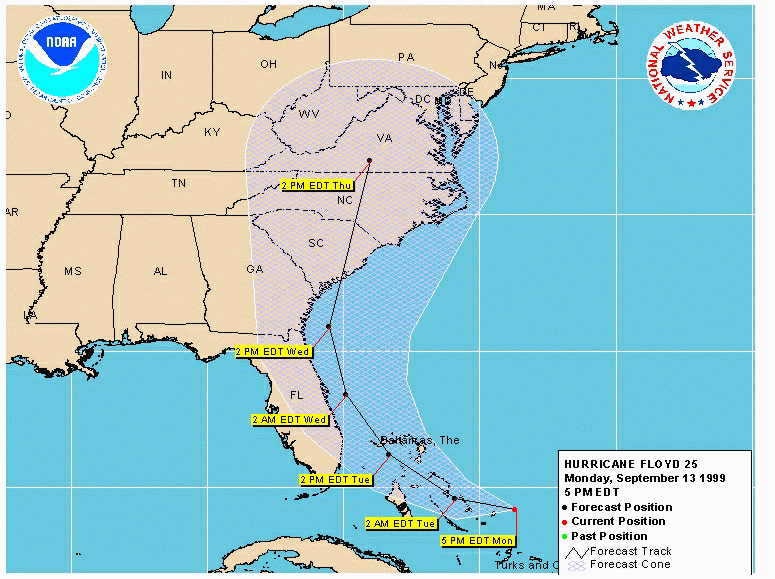
Forecast Cone: This polygon shapefile shows the area of uncertainty of the forecast. This cone is created only if there are forecast data present. It is a statistical area of uncertainty based upon the the fact that the further out in time the forecast is, the less accurate the forecast. Circles are drawn about each forecast point for the statistically predefined radii of uncertainty (defined as 53, 97, 137, 174, and 255 nm). These circles are combined to create the cone of uncertainty.
Past Points: This is another point shapefile that shows the actual track of the storm. This shapefile is populated by adding the initial point of successive forecast advisories. The attributes in the past point shapefile are the same as the forecast positions.
Past Track: This line shapefile connects the points of the past track.
Presentation.
Two forms of presentation of the data are created. The first, directly from ArcView, is a static jpeg image of each active storm. A link to the jpeg is made from the OS tropical page. The jpeg is created after zooming to the forecast cone and zomming out 125%.

Second is the ArcIMS presentation. The ArcIMS presentation is a simple page, derived from the default http template that comes with ArcIMS 3.x. The page contains the standard NWS Corporate banner, a simplified toolbar, and a customized layer list.
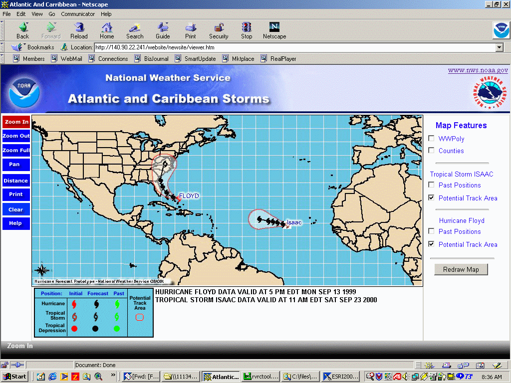
The map.
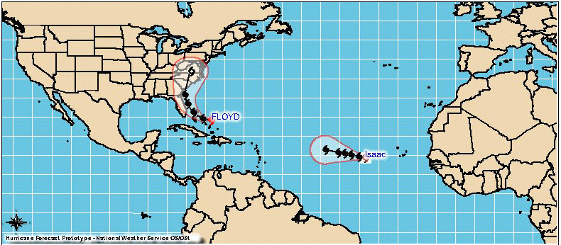
When the page is first accessed, a full view of the entire storm area is displayed. Any and all storms in the area are displayed. The storm name (without the type) is displayed at the initial position of the storm, for each storm.
The toolbar.
The toolbar consists of custom-made blue buttons. For those functions
that act as tools, as opposed to buttons (zoom in vs. print, for example),
the buttons are red when active. The functions behind the buttons
are the standard "out of the box" ArcIMS, zoom in, zoom out, pan,
distance (measure), clear (remove measure lines), and a "zoom full" button,
which is the standard ArcIMS zoom to full extent tool. There is also
a print tool, the print page having been modified to a standard 8 1/2 x
11, that allows the user to add a custom title and to use the legend on
the display page.

The Table of Contents (TOC)
Map layers that do not contain actual storm data appear at the top
of the TOC. The background map and latitude/longitude lines
are not controllable by the user. At the highest level, only county
boundaries can be turned on. As the user zooms in, additional layers
are available. The major cities are defaulted to "on" and the
county and state country-names are defaulted "off". The WWPoly is
experimental and is not used in the online version at present.
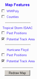
Storm layers, if present, appear next, each separated by a horizontal line. The complete name of the storm (e.g.,. Tropical Storm Isaac, Hurricane Floyd, etc.) is displayed first, followed by the "check" boxes to toggle on or off the forecast cone and past positions layers. The forecast points and track are not accessible by the user. The "refresh map" button has been renamed "redraw map."
The text box.

Future enhancements
We are improving the jpeg presentation and are beginning to decode storm reports for the Western Pacific, which are in a different format than the advisories. Once the decoding software is finished, a web site for the Western Pacific will be created. We also plan to investigate decoding a different text product from NHC which will have the information available that we have now, with additional information regarding the storm's speed and direction of movement.
River Conditions
Overview
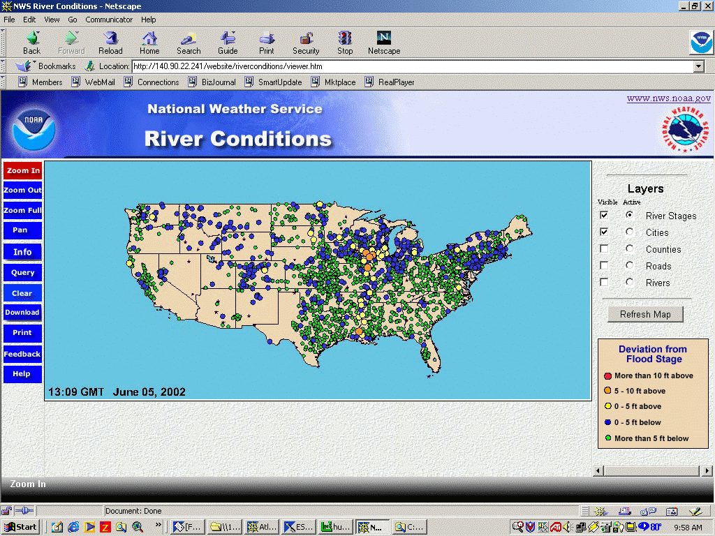
The river conditions project was designed to provide a national overview
of river conditions and to allow the users access to more detailed information.
ArcView GIS, version 3.2, is used to process the input data and create
output products via Avenue scripts. The ArcView application is run
on an hourly basis to create a new map as data are updated.
Processing:
Data from the two data sources, which are delivered to the GEO processor
in a delimited ASCII format, contain an identifier, date/time information,
and an observed river stage value. The two data streams are read
by ArcView, combined into a single "virtual" table, and sorted by site
identifier. The most recent observation is extracted for each location
and is checked to be sure that it is not older than 24 hours. The
table is then compared to a table containing locations with known problems;
matching records are flagged as missing. The data are then joined
a static "locations" table, containing the remainder of the data attributes.
A "delta", or deviation from flood stage, is calculated by subtracting
the observed stage from the flood stage. A check is made for data that
are out of range. Finally, the date and time of the each observation are
copied from the input data and the tables are "unjoined."
Output data.
Data are written to a shapefile and to a dBase file on the GEO server.
The shapefile is used to update a view that is symbolized based on the
the delta values. The layout containing the view is exported to a
jpeg file; the jpeg file is then sent to the web server via ftp.
The local dBase file is copied to the ArcIMS server. The dBase file
contains the same attributes as the shapefile used by ArcIMS. The
dBase file is joined to the shapefile by the id field, and the date, time,
observed, and delta fields are computed using the version of ArcView
running on the sever.
Presentation.
The Static Map
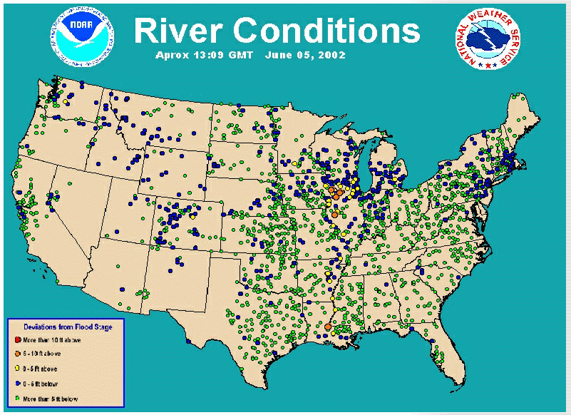
A sample of the static map image that is created from ArcView is shown below. The current version can be found at the HIC Home Page. The dots represent river gauges and are color-coded and sized according to their deviation from flood stage as described in the legend.
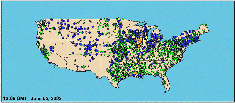
The ArcIMS map shown below was created at the same time as the static map image and shows the same data. The same symbology is used to denote the river gauge locations as was used in the static image
The HYDRO_URL field links, when available, to a hydrograph (defined as a graph showing the water level (stage), discharge, or other property of a river volume with respect to time). Clicking the cell opens a new window to the hydrograph pertaining to the particular point. The majority of the hydrographs linked from the NWS Central Region (ND, SD, WY, CO, NE, KS, MN, IA, MO, WI, MI, IL, IN, and KY) are from the Advanced Hydrologic Prediction Service (AHPS). Hydrographs may also come from the individual Weather Forecast Offices (WFO) or the U.S. Geological Survey. Many NWS hydrographs include forecast conditions as well as observations. Similarly, the WFO_URL provides a link to hydrologic products (statements, forecasts, and flood warnings) issued by WFOs.

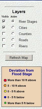
The TOC
The table of contents is a slightly modified standard ArcIMS html toc
which contains layers for river stages, which include the actual river
gauge location and deviation from flood stage, as well as additional layers
for selected cities, county boundaries, roads, and rivers. A legend
has been added to the bottom of the TOC.
Future:
Improvements to the presentation may include the following:
Overview
The Cooperative Precipitation web site was created to allow one of
the RFCs to experiment with IMS technology. Personnel at the West
Gulf RFC (WGRFC) used ArcExplorer 3.1 to design the look and feel
of the web site. At NWS Headquarters, the resultant map configuration
file (AXL file) was used to create the web site. Additional adjustments
were made to the AXL file to access local map shapefiles and to properly
handle the "progressive disclosure" of the precipitation values.
Input data and processing
The input data are provided by the WGRFC as a dBase file. There
are seven dBase files, one for each day of the week, containing total precipitation
recorded during the previous 24 hours. These data are updated once
daily. When new data are detected, an ArcView project joins the appropriate
day's shapefile with the dBase file and updates the shapefile.
Presentation:
With the exception of the NWS Corporate Banner, the web site is the standard out-of-the-box html template provided with ArcIMS software. Layers available to the user are precipitation values for each day of the week, urban areas, roads, RFC boundaries, and background map.
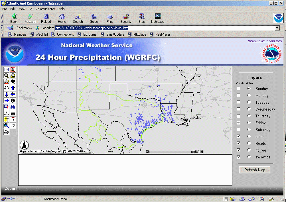
The full view image shows Friday's precipitation values as blue dots. When zoomed in, additional layers are available to the user including cities in the RFC, Mexican Cities, counties, and lakes. In addition, the actual precipitation values are displayed.
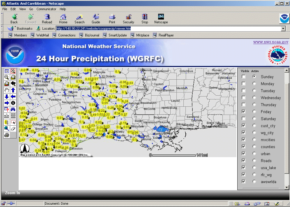
Zoomed in Cooperative Precipitation Web site
Conclusion:
GIS has been used to create/maintain map data for internal and external
use in the NWS since 1995. The AMDC is the the method of supplying
external users with updated NWS map data (forecast zones, counties, etc.).
ArcIMS shows promise as a tool to deliver existing products internally
and externally in an easy-to-use fashion.
Acknowledgments:
To Paula Kingsbury, QSS Group, for her excellent assistance in creating
the very first web sites, and customizing the river conditions web site.
To Dario Leonardo, EG&G Inc., for his unflagging support in administering
the web server. And to Billie Cooper, NWS OST, for proofing the text
of this paper again and again until it was ready for publication.