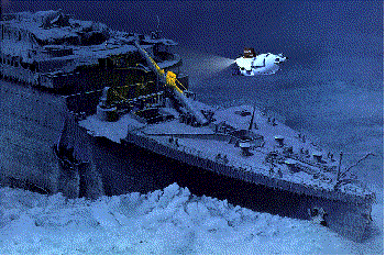
Although ArcView wasn't available to help the submarine ALVIN (figure 1) find the Titanic in 1986, today it is aiding the famous submarine and the oceanographers aboard it in the scientific exploration of the deep sea.
Two research expeditions aboard the R/V Atlantis II (support ship for ALVIN operated by Woods Hole Oceanographic Institution) in the summer of 1995 used ArcView 2 for dive planning and post-dive analysis. The dives were located approximately 300 miles west of the Oregon/Washington coastlines on the Juan de Fuca spreading ridge in water depths of ~2300m (over 1.5 miles deep). Chief Scientist of the first cruise, Dr. Robert Embley of the National Oceanic and Atmospheric Administration's (NOAA) VENTS Program (web link), conducted 11 dives in June/July and Chief Scientist Dr. Paul Johnson of the University of Washington led 10 dives in August/September.
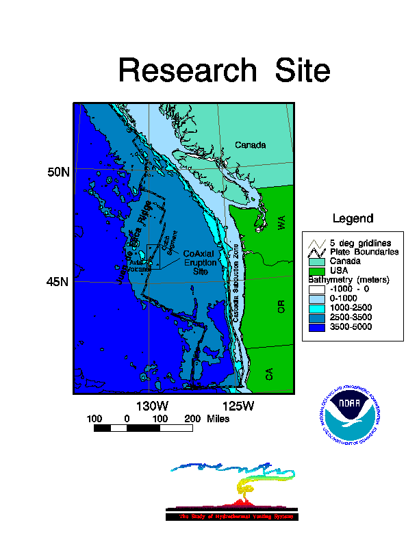
The focus of the dives for both cruises was an area of a recent lava eruption detected in 1993, named the CoAxial Site (web link) due to its juxtaposition between Axial Volcano and the Cobb Segment along the spreading axis. (figure 2) CoAxial is of utmost interest to researchers as it is the first deepsea eruption located using the Navy's SOund SUrveillance System (SOSUS) (web link) and then subsequently verified by oceanographic instruments aboard research vessels on site. In the past, SOSUS was exclusively used by the Navy for detecting Soviet submarine movements. The end of the Cold War has allowed scientists to use this technology for research, such as detection of submarine earthquakes/eruptions and even the location of whales.
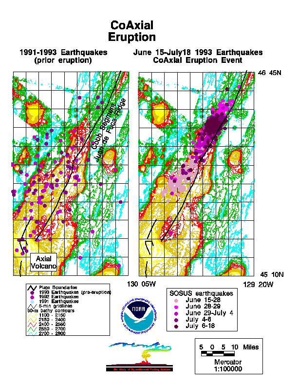
From the VENTS laboratory earthquake events are detected in real-time. The CoAxial eruption's earthquakes first began filling the computer monitors on June 26, 1993 (Figure 3) just a few weeks before a regularly scheduled research cruise to a nearby location. Never before had researchers pinpointed the exact time/location of a deep-sea eruption and be on the site within 2 weeks. Biologist, chemists and geologists from around the world had the opportunity to monitor the evolution of the eruption from its conception. Since 1993, scientists have returned to the eruption area on several expeditions, gathering a wide-range and amount of information.
Even prior to this specific
eruption, integrating the data from the various disciplines was
becoming increasingly complex.
Often individual scientists work only
within their specialty, rarely being exposed to results from
other disciplines that may have significant implications for their own work.
The NOAA VENTS program is one of the first efforts that is truly
interdisciplinary in approach, with scientists ranging from geophysicists to
microbiologists studying the same process; that is, the generation
of new oceanic crust in the deep sea. There is tremendous insight to be
gained through the comparison of interdisciplinary data bases in a graphic,
interactive environment. This is what prompted the development of an
advanced GIS system at NOAA/PMEL.
Early in 1993, VENTS began the design and development of a comprehensive
Juan de Fuca Ridge GIS database. Although available for use within a year, the
GIS was rarely accessed by researchers as it was viewed as too complex,
requiring the services of the GIS specialist or too limited with the
then available graphical user interface, GUI. It wasn't until 1995's
release of a highly functional GUI that gave researchers
with little GIS experience, the power of GIS as an easily-usable tool for
data integration, analysis and display.
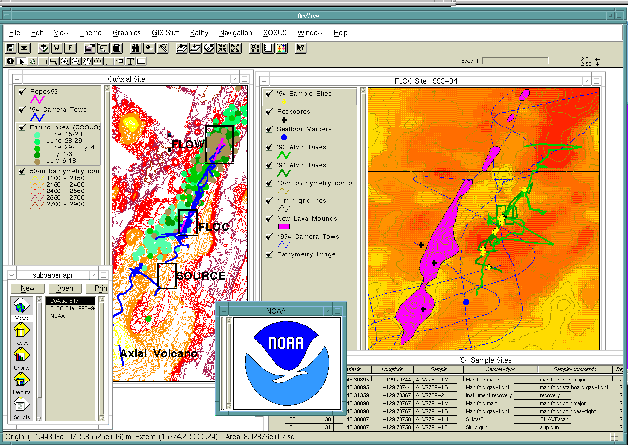
Powerful indeed, as scientists were able to evaluate ALVIN dive plans
with all available information available graphically at the touch of a
button using ArcView 2. Bathymetric contours, prior dive tracks,
marker and hydrothermal vent locations, previous sample sites,
categorized photographs from a deep-towed camera system, areas of new
lava flows and the SOSUS earthquake locations, all were themes available
to the scientists. (Figure 4)
This allowed decisions to be made as to which areas
needed to be re-visited and which new areas needed to be explored
thus most efficiently using the limited dives and bottom time of the
submersible.
ALVIN typically leaves the Atlantis II at 8:30 am and returns the same
day around 4:30 pm. At the depths of the CoAxial site, the submarine
usually needs 1 1/2 hours travel time to reach the seafloor and the same
amount of time to return to the surface. At most, only 5 hours are
available for exploring the bottom. This bottom time is limited by the
amount of battery power available. Dives which use the ALVIN's manipulator
arms extensively (big power drainers) might only have 3 hours on the bottom.
No matter the amount of bottom time, ALVIN and its support ship cost
~$25K/day to operate; therefore, each dive is carefully planned to make
effective use of this expensive national resource. ArcView 2 and the
VENTS ArcInfo database made this planning process easier, quicker and
more efficient for the diving scientists.
Another ALVIN dive consideration is that only 2 passengers may accompany
the pilot to the bottom, and communication with the surface is extremely
limited. Therefore it is impossible to have a geologist, chemist,
biologist and physical oceanographer on each dive. The 2 ALVIN
observers, no matter their specialty, must conduct activities for all
these disciplines. Having an integrated database that can easily relate
the dive's objectives during the dive planning process
helped tremendously in preparing the divers for their mission. For
example, biologists could visualize the geology of their dive sites and
the relationships of distances between features and target sampling
locations. The divers themselves could then create their own maps to
bring along with them inside the submarine. These maps included the
information they needed to complete their objectives.
ArcView 2 at sea was not only used to evaluate previously collected data,
new ALVIN tracklines, deployed markers and sample sites were easily
incorporated using Avenue scripts and ArcView functions. Tables from
spreadsheets could be added effortlessly to the ArcView project Tables.
Then the locations from this table could be displayed on the View using
the "Add Event Theme" function from the View menu bar. The dive tracks
were displayed as lines using the "GPSToShape" script included in the
Avenue Example Script Library. All of this was possible only hours after
the submarine landed on deck. The newly collected information was presented
in the nightly dive de-briefing meetings as colorful maps created
within ArcView's Layouts.
Figure 5.
The diving scientists were then more clearly
able to evaluate and relate their experiences to the other scientists.
GIS at sea with ALVIN was such a success that demand exceeded
supply as far as computers and ArcView software at sea were concerned. For
the cruises ArcView 2.1 was available on an EPS 486PC/66 with 16MB of RAM
and a PowerMac 7100/66 with 33MB of RAM; each had 17" monitors . Both
computers were networked to the ship's SUN Sparcstation. The ArcInfo VENTS
database was loaded directly on both machines for faster operation.
Originally the plan was to have one machine dedicated to data
input/processing for the GIS specialist and the other machine available
for use by the scientists. ArcView 2.1 was so popular
with scientists eager to
analyze their data that the GIS specialists frequently found themselves
without a machine to use! Fortunately data input was so easy with
ArcView and Avenue the that specialists didn't require a full-time machine.
Even so, future operations will be facilitated with additional computers and
ArcView 2.1 licenses.
There is a
large community of scientists outside of NOAA working
on similar problems in the deep sea. The expectation is that the
basic GIS architecture and approach developed by VENTS will be extended to
the broader scientific community, making the GIS not
only an analysis tool, but also a conduit for data exchange and
scientific discourse. We envision a distributed data base system, with
individual data sets residing with the scientists who collected
the data, but with all data products made network-accessible to all
participants. The system has also shown its value in bringing background
information into the field in a compact and flexible manner. The
concept of a "living" data base, with new information collected at
sea being incorporated immediately into the GIS onboard the ship, will
greatly enhance the efficiency of our field efforts."
The future of GIS in deep-sea oceanographic exploration is very bright.
VENTS scientists and their colleagues will probably never go to sea
using submersibles without a portable ArcView GIS system. Scientists
aboard these cruises from other institutions are writing proposals to develop
their own ArcView/ArcInfo GIS systems for deep-sea applications in other
parts of the ocean. There is also discussion of having ArcView available
on a laptop inside ALVIN for interactive GIS analysis during the dives
(although once on the bottom, even ArcView can't beat the "view"
out the porthole).
Figure 1. Underwater photograph of DSRV Alvin. ALVIN is used by scientists
thoughout the world to conduct research of the the world's oceans. Also shown
is an artist's rendition of ALVIN exploring the wreckage of the famous
passenger ship Titanic.
Figure 2. ArcView layout illustrating the location of the CoAxial research
site. The site lies along the Cobb Segment of the Juan de Fuca Spreading
system approximately 200 miles off the west coast of Oregon and Washington.
Figure 3. Earthquake locations detected by the SOSUS system prior and during
the CoAxial event. The system became operational in the fourth quarter of
1991 and has been in continual use through the present. ArcView graphically
illustrates the relatively few background events in comparison to the linear
progression of events occurring within a month associated with the eruptive
event.
Figure 4. Screen capture of an ArcView session used by ALVIN passengers
prior a dive. Divers could retrieve information regarding previous visits
to the dive site in preparation of their dive plans.
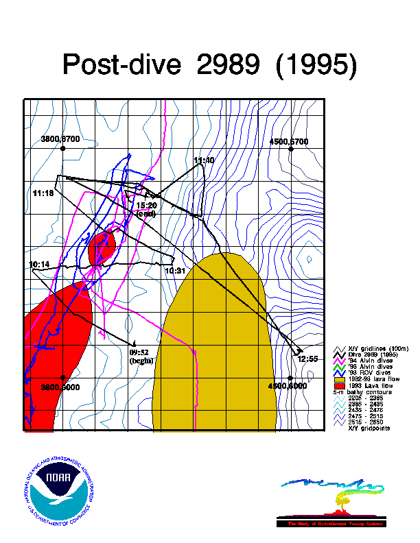
Figure 5. Post-dive map typically presented at the evening scientific
briefings at sea. Divers could easily relate sample sites and locations
of interesting observations to other researchers.
Bobbitt, A.M., GIS for ALVIN Exploration, RIDGE Events, 7(1):10-12, 1996
Wright, D.J., ArcView Supports Sea Floor Exploration, ARCNews, 18(1)14,
1996.
Wright, D.J., Rumblings on the ocean floor: GIS supports deep-sea research,
Geo Info Systems, 6(1):22-29, 1996.
VENTS Data
ALVIN
ArcView and ALVIN
Future Plans
Figure Descriptions
Related Publications
Andra Bobbitt
Research Assistand/GIS Specialist
NOAA VENTS Program
Cooperative Inst. for Marine Resource Studies
Oregon State University
2115 S.E. OSU Dr.
Newport, OR 97365
Telephone: (541)867-0177
FAX: (541)867-3907
email: bobbitt@pmel.noaa.gov
Chris G. Fox
Researcher
NOAA VENTS Program
Pacific Marine Environmental Laboratory
Ocean Environmental Research Division
2115 S.E. OSU Dr.
Newport, OR 97365
Telephone:(541)867-0276
FAX:(541)867-3907
email:email:fox@pmel.noaa.gov
Dawn J. Wright
Assistant Professor
Oregon State University
Department of Geosciences
104 Wilkinson Hall
Oregon State University
Corvallis, OR 97331-5506
Telephone:541-737-1229
Fax:541-737-1200
email:email:dawn@dusk.geo.orst.edu