ICE MAPS is a powerful custom map generator consisting of a combination of ArcInfo Arc Macro Language (AML) programs and a Perl script that work together to provide access to spatial and tabular data. The system allows Internet users to navigate to an area of interest within California, select the data layers desired for a final map, and have our Web server and GIS software produce the map. The user then has the option to download GIF or PostScript files of the custom-made map and its legend. The URL for ICE MAPS is http://ice.ucdavis.edu/ice_maps.
The Information Center for the Environment (ICE) is housed in the Division of Environmental Studies at the University of California, Davis (UCD). UCD ICE is a cooperative facility supporting projects of an interdepartmental faculty with funding from a diverse group of supporters, including the California Biodiversity Council, the California Department of Fish and Game, the California Department of Parks and Recreation, the California Water Resources Control Board, the Long Term Ecological Research (LTER) Program of the National Science Foundation, the Man and the Biosphere Directorate at the State Department, the National Biological Service (NBS), the National Park Service, the Nature Conservancy, and the US Environmental Protections Agency (EPA).
The main goals of UCD ICE include providing GIS, database systems, and modelling support to environmental resource projects, and developing easy-to-use public access to a wide variety of environmental information. UCD ICE is a bootstrap cooperative project that is developing easy-to-use public access to a wide variety of environmental information, located both on the UCD ICE Web server and throughout the rest of cyberspace. We support databases and Internet tools for numerous organizations and have helped hundreds of users who had no previous access or experience get connected to the Internet. UCD ICE also maintains extensive lists of on-line environmental and other bibliographies, of data management and meta-data sources, and of other environmental sites on the Internet. The UCD ICE Web server is now accessed over 17,000 times per week from all over the world.
UCD ICE may be accessed over the World-Wide Web using one's favorite Web browser (such as Mosaic or Netscape) at
or from numerous other environmental or governmental servers.
Most base layers for ICE MAPS have been provided by the California State Teale GIS Technology Center through our Memorandum of Understanding with the California Department of Fish and Game. Unfortunately, we are unable to redistribute this data in its raw form to other members of the public because of the nature of the agreements under which Teale data are supplied. Teale is required by state policy to recharge users for the costs of assembling and disseminating its data holdings. Current policy leads to an annual subscription charge of about $10,000, placing access to Teale data out of the reach of many organizations, such as local planners and watershed groups, which are dependent upon reliable natural resource data. We are, however, able to allow users to view and query derived data and maps via the Internet. If users require access to the underlying data, then they must contact the Teale GIS Technology Center directly.
Our intention in creating the CARA Web to GIS system was to move beyond the simple display of static snapshots of river resource information by allowing the user to interactively query the GIS and other databases via the Web. In response to the obvious need of the public and decision-makers to have access to river resource data, and our inability to redistribute a large proportion of our data holdings, we developed a method allowing Web users to combine data sets for visual display and local print out.
In this early system, each of the 10 CARA pilot basins had maps available for several themes, including vegetation, shaded relief, land ownership, major roads, natural diversity database (NDDB) occurrences, and rivers. These individual maps were already available in PostScript format to facilitate downloading and printing by the user, although they were only available as single theme maps. The user had no say in what features appeared on the output map. Our Internet users, including watershed groups and agency scientists, requested the ability to produce customized maps. In order to allow the user more control of the layers being mapped, we developed the the CARA Web to GIS system.
Several steps were required in developing the Web to GIS system:
The last three of these steps were accomplished by a Web server CGI program written in Perl. CGI (Common Gateway Interface) is a formal specification for running arbitrary programs from a Web server. Perl is a public domain scripting language that is commonly used for CGI programs. We chose it as the link between the HTML forms interface and ArcInfo mainly because our UNIX expert wanted to learn Perl and this use presented a suitable opportunity. (Perl is an acronym that expands to either "Practical Extraction and Report Language" or "Pathologically Eclectic Rubbish Lister" according to Wall and Schwartz 1991.)
Developing a WWW to ArcInfo interface for CARA required programming expertise with ArcInfo, UNIX, and Web server software. We had already written an AML that produces a plot of individual layers within the CARA demonstration basins. It was straightforward to modify the existing AML to accept parameters (arguments) defining the map to be produced. The Web to GIS system we developed using a Perl script in conjunction with an AML was successful and very rapidly became a popular Web site.
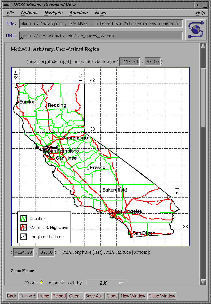
There are two types of navigation. Figure 1 shows the first method which we call Arbitrary, User-defined Regions. This method uses the map that appears near the top of the ICE MAPS page and several sets of the interface controls immediately above and below the map. The user navigates within the map by selecting a point on it with the mouse. The spot that is selected becomes the center of the new map. The zoom factor associated with the selectable map is controlled by using the pull-down menu and the pair of buttons indicating whether one is zooming in or out. The user can further refine the extent of the desired region by using the coordinate text entry boxes located just above and below the map. These entry boxes display the latitude and longitude coordinates on the on-screen map and can be edited by entering explicit coordinates.
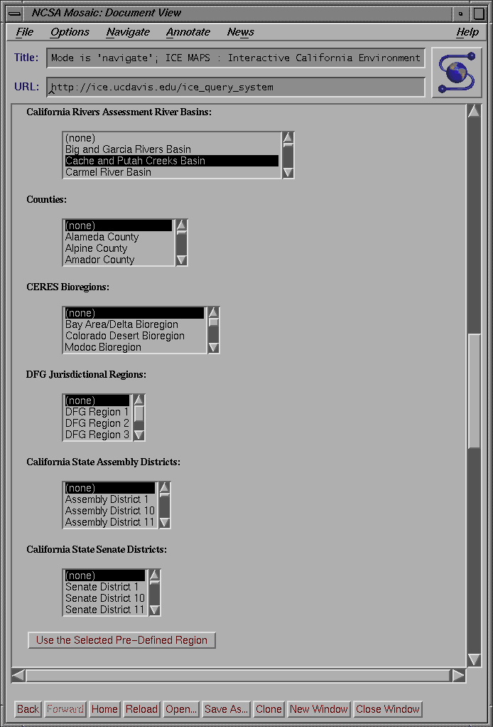
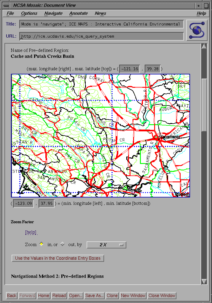
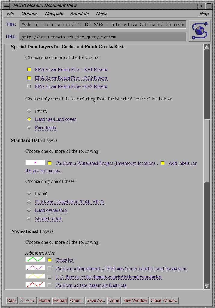
The second navigation method, Pre-defined Regions , is indicated in Figure 2 . In this case, the user chooses a pre-defined region by name from one of a number of lists. The selection of a region fixes the boundaries of the geographic region. A map for this region is displayed when the user activates the Use the Selected Pre-Defined Region button. The user may also set navigation layers (Figure 3) before using the Select Region button. Only one pre-defined region may be chosen at a time. Should the user decide not to include a region of the selected category, the none choice should be selected.
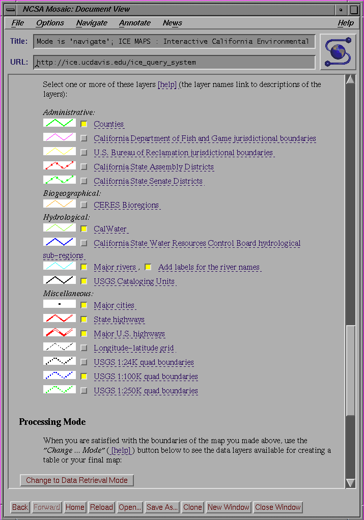
To aid the user in navigating to the region of interest, there are a number of different GIS data layers from which to choose (Figure 3). Examples are county boundaries, major rivers, USGS Cataloging Units, and major US highways. The user chooses the layers by clicking on the check box. Each layer also includes a small in-lined image that serves as a legend for the map symbols. The text for the layer serves as a link to metadata describing the source information for that layer.
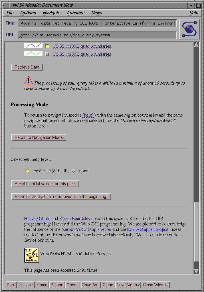
Once the user is satisfied with the boundaries of the geographic region, which may include many iterations and intermediate maps (Figure 4 ), the Change to Data Retrieval Mode button on the ICE MAPS screen is selected (bottom of Figure 3). This switches the interface to data retrieval mode.
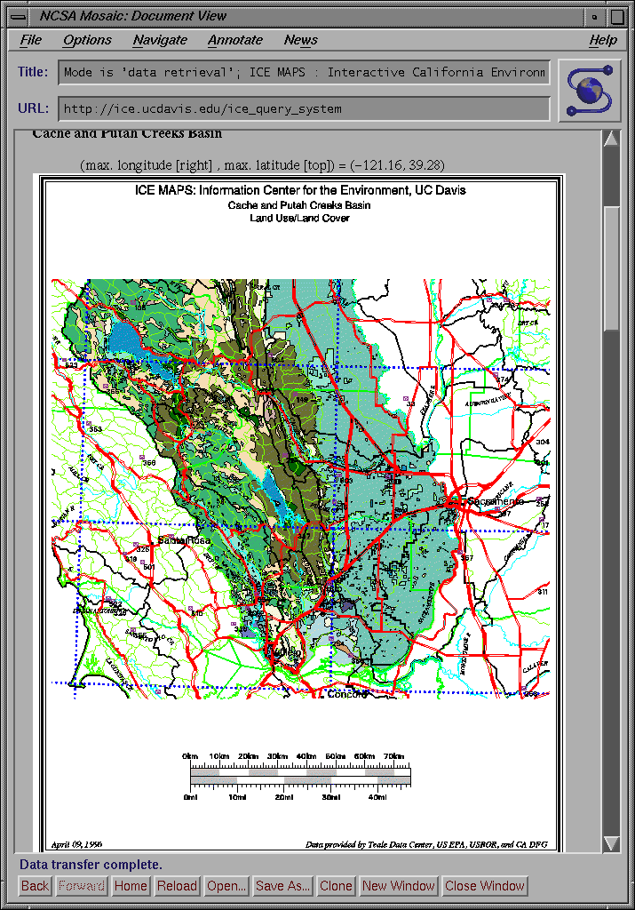
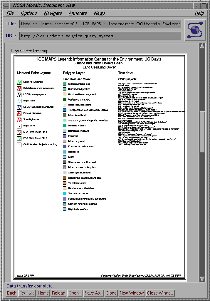
The output of Data Retrieval Mode consists of a map (in several formats), hyper-text links to sources of information related to the user's query, and optional tables of information. The response form includes an in-lined GIF file of the map (Figure 7) and the legend (Figure 8). Map formats available for downloading include PostScript and GIF. For some data and navigational layers, there are hyper-text links to on-line sources of information related to those layers. An optional kind of output is tabular dta contained in one of more files. If these tables are created, there will be hyper-links to them.
An extensive and helpful set of instructions exists to help users use ICE MAPS. These instructions are located at http://ice.ucdavis.edu/ice_maps/help.html .
Environmental decision making in California and throughout the country is becoming increasingly decentralized. Hundreds of cooperative grassroots organizations, such as watershed councils, cooperative resources management planning efforts, and friends of the river groups, have emerged to promote environmental protection and restoration work. State and federal agencies have been particularly active in supporting projects to protect natural resources, yet these agencies need to better understand the successes and limitations of competing approaches.
All of these activities require a body of environmental information that is freely available and is viewed by competing parties as reliable and impartial. To meet this need, new cross-organizational data access centers are needed. Information must be accessible at low cost and in standardized formats to the non-specialists of impoverished grassroots groups and local governments. Given their diverse needs and capabilities, users should be able to customize queries and maps to their individual requirements.
UCD ICE has strived to provide a model of how to better deliver environmental information to the public. Users may access statewide databases and GIS coverages of river environments through standardized, freely-available software. Our recently developed interactive natural resource query system, ICE MAPS, provides a dramatic improvement over previous systems by allowing Internet users to navigate to desired regions and design and output customized maps. We are expanding the system to include tabular queries and ultimately plan to incorporate the remote submission of updates for ICE environmental databases using HTML forms.
We acknowledge the influence of the Xerox PARC Map Viewer and the Esri-Mapper project in the development of ICE MAPS.
The California Department of Fish and Game (DFG) has graciously provided data layers that are included in ICE MAPS. Many additional layers were provided by DFG through a license agreement with the Teale GIS Technology Center.
The work described here was supported by the California Resources Agency and the U.S. EPA (R819658) Center for Ecological Health Research at UC Davis. Although the information in this document has been funded in part by the United States Environmental Protection Agency, it may not necessarily reflect the views of the Agency and no official endorsement should be inferred.
Wall, Larry and Randal L. Schwartz. Programming perl . Sebastopol, CA: O'Reilly & Associates, Inc., 1991.
Karen Beardsley
GIS Coordinator, Information Center for the Environment
Division of Environmental Studies
University of California, Davis
Davis, California 95616
Telephone: (916) 752-0532
Fax: (916) 752-3350
E-mail:
kbeardsley@ucdavis.edu
James F. Quinn
Director, Information Center for the Environment
Professor, Division of Environmental Studies, UC Davis
E-mail:
jfquinn@ucdavis.edu