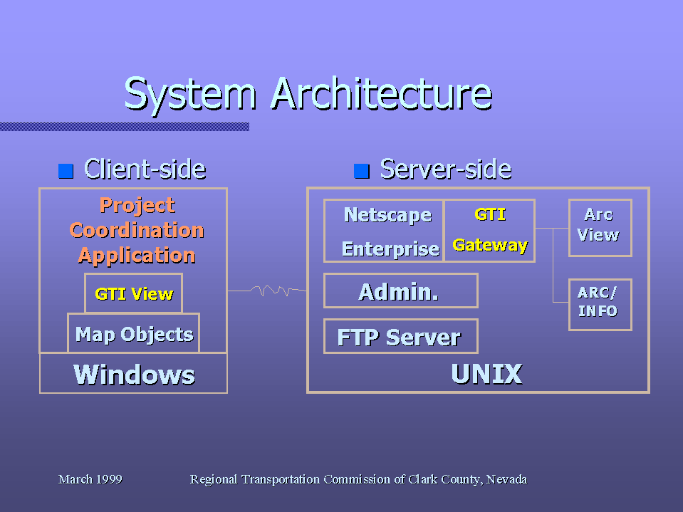
Figure 1: The Project Conflict Avoidance application architecture and communication environment.
Author: David Granata
Paper Number: 442
The Regional Transportation Commission (RTC) of Clark County, Nevada is responsible for planning and coordinating the major transportation projects for the greater Las Vegas area. The local entities and utility agencies as infrastructure providers have major construction projects that involve and impact regional transportation. Through the Utility Coordination Subcommittee, the RTC provides a forum for each entity to be informed of each other's projects in an effort to minimize construction costs, impacts on regional transportation, and the general public.
Ineffective coordinations of these major construction projects have
large impacts such as extra costs, regional transportation congestion,
and inconvenience to the general public. Project conflicts arise
from spatial and temporal issues. Spatial, or locational project
conflicts cause problems with traffic congestion when several major street
arteries have projects proceeding at the same time in the same general
area. Temporal, or time, conflict causes problems with unnecessary
costs and prolonged traffic disruption. These problems and extra
costs can be minimized or eliminated through effective coordination of
all the transportation related projects.
The local entities and utility agencies can make better project scheduling
decisions to improve coordination and minimize project conflicts by employing
a Geographic Information Systems (GIS) application. This application
improves project coordination by capitalizing on GIS capabilities to provide
location and time information about projects through map inquiries.
This GIS application utilizes a server based approach with network access
to minimize the software and hardware costs and requirements to the individual
local entities and utility agencies. This application provides an
interactive graphical environment to query, update, and add information
about construction projects. This capability makes it possible for
the entities and utility agencies to be pro-active in their project scheduling
and allow for more effective traffic management.
The Regional Transportation Commission (RTC), as the Metropolitan Planning Organization (MPO) for Clark County Nevada, is responsible for planning and coordinating the major transportation projects for the greater Las Vegas Valley Metropolitan area. The local jurisdictional Public Works and public and private Utility agencies, as infrastructure providers, have major construction projects that involve and impact regional transportation. The RTC created the Utility Coordination Committee (UCC) to provide a forum for each entity to be informed of each other's projects in an effort to minimize construction costs, impacts on regional mobility, and impacts to the general public.
The RTC defined and developed a client/server-based
GIS application to support this construction project conflict avoidance
effort. This application links together all of the UCC agencies and allows
construction project information to be captured, updated, viewed, and analyzed
on-line in a real-time environment.
THE PROBLEM
Ineffective coordination of major construction projects impacts on costs, regional transportation congestion, and inconvenience to the general public. Project conflicts arise from spatial and temporal issues. Spatial, or conflicts between construction projects due to location, cause problems with traffic congestion and frustration to the motoring public. An example of this type of conflict occurs when several major arterial streets have construction projects proceeding at the same time in the same general area. Temporal, or conflicts caused by construction project schedules, cause problems with unnecessary costs when the same work is re-done in the same area at different times as well as creating prolonged traffic disruption.
Poor coordination can be costly. Agencies spend more money and time on projects where coordination has not been done well. Higher costs for construction are passed on to the public. Situations were adjacent arterial streets having concurrent ongoing construction causes travel delays, route closures, and inconvenience to the traveling public. Construction done and redone in the same area requiring streets to be cut, patched, and re-cut in short succession creates a poor image for public agencies and adds costs. These problems and extra costs can be minimized or eliminated through effective coordination of all the transportation related construction projects.
The UCC meets once a month to review a
listing of the major construction projects. A spreadsheet was manually
compiled from the construction project information sheets supplied by the
UCC members. The various agencies use this forum to coordinate the projects
on the list. This methodology has been successful but it has long been
identified that automation would improve coordination even more. The Public
Works and Utility agencies knew that they could make better project scheduling
decisions and improve coordination while minimizing project conflicts by
employing a GIS application. This application would improve project coordination
by capitalizing on the inherent GIS capabilities to provide location and
time information about construction projects through map inquiries.
THE SOLUTION
A need assessment study was conducted to determine the best solution to construction project conflict avoidance. This study identified and documented the construction project coordination problem, the requirements for a solution as defined by the various agencies, the constraints for a solution as defined by the environments of the various agencies, a conceptual solution meeting the requirements and constraints, the anticipated projected costs and benefits to the solution, any risks associated with the solution, and recommendations.
The study identified that the chosen solution would need to minimize costs for hardware and software. A centralized common database would be needed. The addition of GIS staff to run this application was not a solution. Finally, for the application to be useful the information had to be timely and accurate by keeping the responsibility of data input with each of the agencies. The application would need to create a "virtual mainframe" computer environment between the UCC agencies. These influences required a unique approach for a GIS computer application. The application solution required client/server-based technology. The communication environment existed by using the internet. The identified high-end GIS functionality and administrative/security functions would require unix-based server technology.
New approaches in the GIS industry were
essential for the defined solution. Due to the risks defined with this
approach, it was determined that contracting for outside expertise would
be necessary. The need assessment documented what the application software
would be required to deliver. A contract was created for the defined application.
The contract specifications were based on the need assessment documents
that had been produced. The contract stipulations required software that
created a "virtual mainframe" in delivering a distributed application using
a centralized database, supply the defined GIS functionality, provide the
identified spatial and temporal conflict analysis functions, and exploit
the UCC membership's existing computers and network connections in order
to minimize costs. A consulting firm with proprietary software that would
enable the defined approach was found in GIS Technologies, Incorporated
(GTI) of Redlands, California.
THE APPLICATION ARCHITECTURE
Creating a "virtual mainframe" environment involved client/server technology. Communications for this environment would require using the internet. Communications between the client workstation software and the server software would have to be handled using HTTP and FTP technologies. To keep costs low, the expensive high-end GIS functionality would need to be provided from the server also using the HTTP and FTP communication environment. Establishing this communication environment is the key component to making the defined application work. GTI proprietary software already existed that developed this type of communication environment.
Figure 1: The Project Conflict
Avoidance application architecture and communication environment.
The client-side software operates in the windows operating system environment. MapObjects (Esri) provides the base GIS functions. Proprietary software of GTI View provides the thick client approach using HTTP and FTP communications. The thick client approach downloads files to the local workstation so that GIS functions can be run using the client CPU as much as possible to improve response time performance. GTI View would also need to be customized to supply the construction project conflict avoidance specific functions such as; conflict identification both spatial and temporal, login security, add/modify/delete/digitize data, and to generate report and plot products.
The server-side software operates in the UNIX operating system environment. Proprietary software of GTI Gateway is required to provide the thick client approach over the Internet and the HTTP and FTP communications environment. GTI Gateway also provides the high-end GIS functions that are required through it's capability to serve ArcView (Esri) processes or scripts and Arc/Info (Esri) processes or AML's over the Internet. Custom functions for; database management routines to check-out and check-in files, database add/modify/delete processes, user account management routines and security authentication, and for the file transfer communications environment are server-side software functions.
The presentation provides a live demonstration of the client application.
The subsequent HTML link provided a walk-thru of that demonstration using
screen captures.
P442DEMO.htm
The Public Works and Utility agencies of the UCC can accurately visualize the construction projects in an easy graphical manner. This allows the agencies to make better construction project scheduling decisions leading to improved coordination and minimizing conflicts. The application goal of minimizing cost is achieved by using the existing workstations and exploiting the existing Internet communications. Application response time is maximized using a thick client/server approach.
The windows-based client-side approach provides a familiar easy-to-use user interface to the application. Taking this approach makes the application easy to use for the non-GIS professional. The inherent GIS graphical qualities allow clearer visualization and understanding of the construction projects. Because of that fact, the UCC members can become pro-active in scheduling construction projects as well as with conflict avoidance.
Improved visualization of construction
projects will allow the RTC to manage traffic flow within the region more
efficiently. More effective construction project conflict avoidance is
sure to improve the RTC's, Public Works entities, and Utility agency's
image and reputation with the public.
FUTURE
The future course for this project is to
monitor the usefulness of this application. Through utilization and experience
with this application the UCC membership is sure to identify desired enhancements
and improvements in the software's sophistication. The longer range goal
is to provide up-to-date construction project information to the public
through the Internet. The information gathered through this application
will be the basis for such an effort.
Author's Information:
David Granata
Senior GIS Analyst
Regional Transportation
Commission
of Clark County, Nevada
600 S. Grand Central
Pkwy.; Suite 350
Las Vegas, Nevada 89106-4512
Phone: 702.676.1500
E-mail: granata@rtc.co.clark.nv.us