Paper # 397
Minnesota Department of Natural Resources
LandView -- Map Objects Application
Development -- July, 2001
|
Paper # 397 Minnesota Department of Natural Resources
|
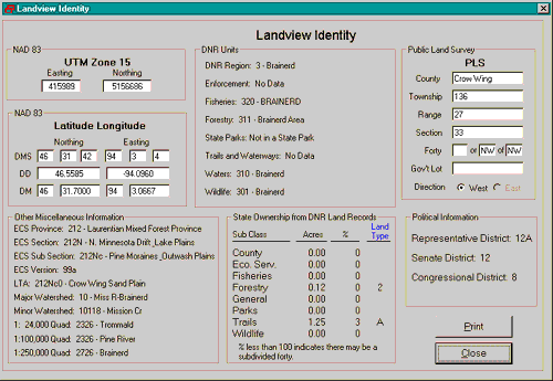
The Identity tool allows querying
many databases for information about a specific location. Select the tool
by clicking on the button at the top of the Display Window that looks like ![]() .
Once selected, move the cursor to the desired location on the map and click
the left mouse button to bring up another window with a wealth of information
about the location such as latitude/longitude, DNR Land Ownership, PLS,
DNR Divisional Administration, etc (See above Graphic).
.
Once selected, move the cursor to the desired location on the map and click
the left mouse button to bring up another window with a wealth of information
about the location such as latitude/longitude, DNR Land Ownership, PLS,
DNR Divisional Administration, etc (See above Graphic).
Note: The text where it says "Land Types" in the information box is clickable. It lists what the different Land Type Codes mean for easy reference.