Paper # 397
Minnesota Department of Natural Resources
LandView -- Map Objects Application
Development -- July, 2001
|
Paper # 397 Minnesota Department of Natural Resources
|
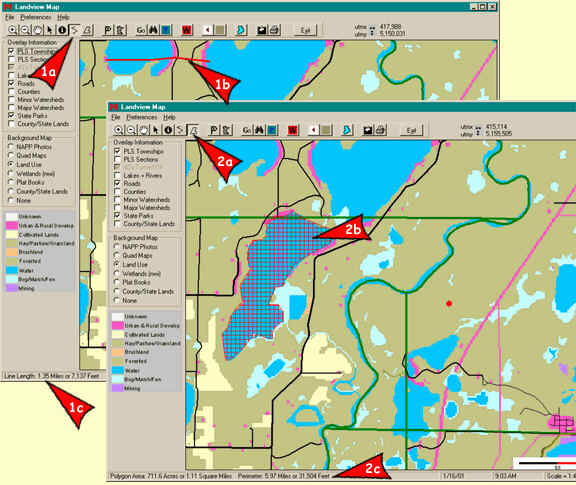
Distance Tool
The Distance Tool is used for calculating
a distance from within the Display Window. Use it by selecting the button
that looks like ![]() (1a).
To begin the distance calculation, click once with the left mouse button
at the desired location and continue clicking in different places on the
map until the intended path has been drawn out (1b). When the path
is complete, double click the mouse at the end of the path (this will end
the line). The distance in miles and feet of the path will be displayed
at the bottom of the screen (1c).
(1a).
To begin the distance calculation, click once with the left mouse button
at the desired location and continue clicking in different places on the
map until the intended path has been drawn out (1b). When the path
is complete, double click the mouse at the end of the path (this will end
the line). The distance in miles and feet of the path will be displayed
at the bottom of the screen (1c).
Note: When using this tool the line must be completed with a double click from within the map canvas before you can use any other tools or menu options.
Area Tool
The Area tool allows the user to
calculate the total acreage, square miles, and perimeter of a user defined
region on a map from within the Display Window. Enable it by selecting
the button that looks like ![]() (2a). Use it by drawing a polygon on the map for the desired area
to be calculated. Do this by clicking once and moving the mouse several
times and clicking to make vertices (2b). To finish the process
double click the mouse at the point that closes the polygon (the last point
closes the polygon at the place where you made the first click). The acreage,
square miles, and perimeter of the region will be displayed at the bottom
of the screen (2c).
(2a). Use it by drawing a polygon on the map for the desired area
to be calculated. Do this by clicking once and moving the mouse several
times and clicking to make vertices (2b). To finish the process
double click the mouse at the point that closes the polygon (the last point
closes the polygon at the place where you made the first click). The acreage,
square miles, and perimeter of the region will be displayed at the bottom
of the screen (2c).
Note: When using this tool the line must be completed with a double click from within the map canvas before you can use any other tools or menu options.