Technical issues and time constraints have historically made it prohibitive to complete geomorphologic analyses on relatively large and complex study areas. This paper will present the results of a study that utilized a GIS to investigate watershed and channel morphologic relationships on the USDA-ARS Walnut Gulch Experimental Watershed near Tombstone, Arizona. The goal of this study was to derive predictive relationships for stream channel characteristics using a high-resolution ArcInfo GIS (ARC) database (1). Over two hundred channel cross-sections were surveyed within the boundaries of the watershed, and a suite of ARC AMLs were developed to analyze each of the subwatersheds contributing runoff to the sample points. Each of these subwatersheds were characterized based on information extracted from the GIS, including such variables as watershed area, stream order, flow length, and slope. Regression analysis showed highly significant relationships between the channel characteristics (average width, depth, and cross-sectional area) and watershed variables. These results indicate that the procedures used in this study could greatly improve our understanding of geomorphologic processes, as well as provide tools to assist in the parameterization of hydrologic models.
With the advent of geographic information systems (GIS), quantitative analyses necessary for watershed and hydrologic modeling could be carried out rapidly and accurately, allowing for the construction and execution of large-scale geomorphologic investigations. This paper presents the results of a project that utilized the ArcInfo GIS in watershed and channel morphologic analyses on a large-scale, high-resolution database. A detailed geomorphologic study of channel cross-sections was undertaken on Walnut Gulch Experimental Watershed near Tombstone, Arizona, which is administered by the USDA-ARS. A GIS database was developed for Walnut Gulch with a scale and resolution not usually attempted (Burrough, 1986), and theme layers needed to complete the watershed analysis were created using innovative mapping techniques. Field data was subjected to statistical analysis, which provided the mathematical link between data stored in the GIS and that collected in the field.
ARC Macro Language (AML) routines were created to aid in the derivation of subwatershed boundaries and in characterizing areas contributing runoff to each of the 222 sample points randomly located on Walnut Gulch. These AMLS were set up such that once a subwatershed was created, multiple watershed parameters were automatically extracted from the GIS and transformed to flat file format for importation into statistics and spreadsheet packages. A 10m resolution digital elevation model (DEM) served as the theme layer from which subwatersheds and some watershed characteristics such as slope, flow length, and elevation change were derived. In the field multiple measurements of channel width and depth were taken at each of the sample points. Deviations in channel shape were accounted for on a watershed scale through the sample design and at the local level by repeated measurements.
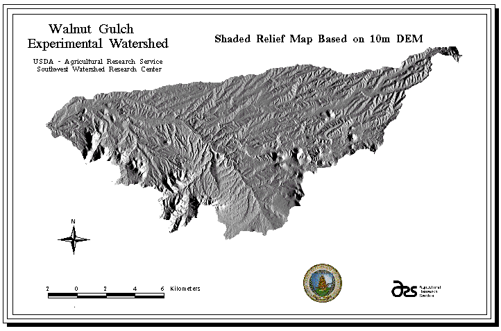
Located in southeastern Arizona, the vegetation of Walnut Gulch Experimental Watershed is characterized as scrub-grassland. Although limited in scope, urbanization exists within the watershed boundary. Cattle grazing and recreational activities are the major land uses. Vegetation within the watershed is representative of the transition zone between the Chihuahua and Sonoran deserts, and is composed primarily of grassland and scrub rangeland vegetation. A high alluvial fan of Cenozoic age, very thick (greater than 400m in depth) and coarse-grained underlies the watershed (Breckenfield et al., 1995) and contributes runoff to the San Pedro River watershed (Renard et al., 1993). Due to the enormous thickness and extent of the alluvial fill, the groundwater reserves are substantial, and can be found at depths ranging from 50 to 145m (Libby et al., 1970).
The climate of Walnut Gulch has been classified as semiarid or steppe. Mean annual temperature in the city of Tombstone is 17.6 deg. C, with mean annual precipitation of 324 mm. Annual precipitation is highly variable, both in timing and amount. Rain occurs primarily during two distinctive storm seasons: summer rains are the product of monsoonal, highly localized, convective storms; winter rains are generally low-intensity events that cover a larger proportion of the watershed. The majority of runoff occurring on Walnut Gulch is the product of summer storms, and is therefore episodic and of relatively high intensity (Renard et al., 1993).
Theme layers with a high degree of accuracy and resolution were developed within ARC for Walnut Gulch. Most of the primary theme layers were developed using 1:5000 orthophotographs. A 10m resolution DEM was created from spot elevation data, contours, and the stream network coverage using the ARC tool "topogrid" (Environmental Systems Research Institute, 1994). GIS coverages important to the study included polygon maps for soils, range sites, vegetation, geology, surface elevation, and stream networks (a combination of polygon and vector topology).
Channel Network
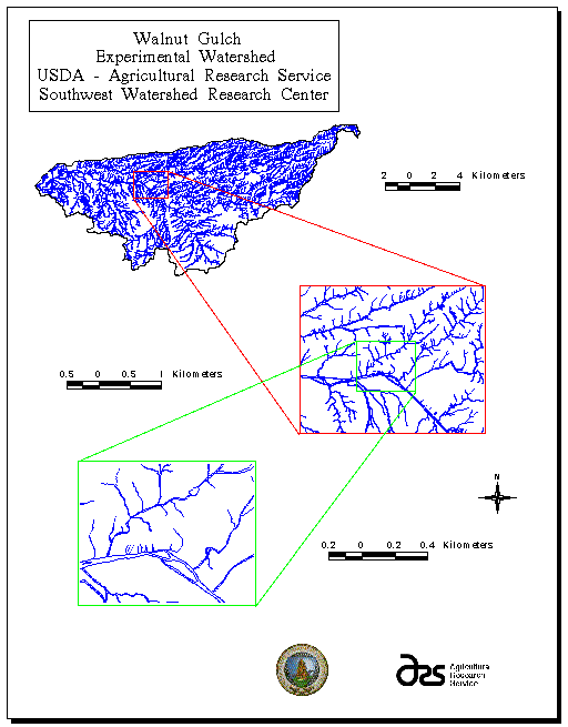
Of primary importance to the study was the creation of a highly resolved channel network theme layer. Orthophotograph mylar sheets at 1:5000 scale served as the base information from which stream channel information was drawn. Incised channels greater than approximately 1.5 meters wide were digitized as polygons, with channel islands and bars defined where visible on the orthophotographs. Channels less than approximately 1.5 meters were digitized in a more typical GIS fashion; as vectors which bisect the channel boundaries. Where visible, alluvial fans were delineated as part of the channel system. This channel network coverage therefore contains a great deal of information related to channel geometry, information which may be extracted from the GIS and compared to data collected in the field.
Sample points for the collection of field data were located randomly across Walnut Gulch using a random number generator and ArcInfo. Although the sample locations are referred herein as "points," measurements of channel and geomorphologic characteristics were focused not at a single location, but rather on the internal drainage links. At the closest channel link to a randomly located point, published procedures for measuring channel shape were followed (Osterkamp et al., 1983; Gordon et al., 1992; Harrelson et al., 1994). A channel link is defined as a channel section between two channel confluences (Leopold et al., 1964).
At each location indicators of bankfull depth, such as break in slope, change in vegetation or bank materials, and bank staining, were used to locate the top of the channel cross-sections. A light-gauge line was pulled perpendicular to the channel at the bankfull depth and drawn level using a small line level. At each break in slope across the channel the length from the left bank and depth to channel bottom were recorded. Average values for channel width, depth, and cross-sectional area were derived from these measurements.
One of the most time-consuming and challenging aspects of performing geomorphologic assessments has been the characterization of watersheds necessary to derive predictive relationships (Gordon et al., 1992). To provide a basis for investigating the statistical relationships between watershed and hydrologic variables, an array of variables was constructed from field-based and GIS data collected during this project. Dependent variables were measured in the field and were used to quantify several channel shape characteristics that are influenced by upstream basin characteristics. A suite of AMLs was developed to aid in the extraction of data and the characterization of watersheds contributing to each sample point. The rapid and consistent extraction of relevant information allowed for the complete characterization of a large number of sample points. This process would not have been feasible given the time available without a GIS.
Stream Channel Ordering
Because stream order has been shown to be highly correlated with channel shape (Strahler, 1964; Leopold et al., 1964) a stream ordering routine was developed in AML that takes advantage of vector topology. To utilize the rapid processing afforded by vector topology, the stream channels delineated in the GIS were all reduced to single lines. The resulting lines were transformed back into vectors and analyzed using the ordering AML program. Similar in concept to the ordering routine developed by Lanfear (1990), this AML works in ARCEDIT rather than as an external process, and can be error-checked using routine ARCPLOT visual aids. The AML analyzes the attributes of each stream vector but uses the associated "from nodes" (fnodes) of the channel network as the database element on which to sort.
According to Strahler ordering, a channel can only increase in order if two channels converge which are of the same order. Each of the fnodes are tested as to whether or not the incoming arcs satisfy that criteria: if they do then the downstream arc is ordered by adding one to the upstream order value; if one of the upstream arcs is unordered, then the downstream arc is skipped during that pass through the data; and if both upstream arcs are ordered but not of the same value, then the downstream arc is assigned an order value equal to the greater of the two upstream arcs. Because arcs can only be ordered if all the upstream arcs have been ordered previously, the AML was set to sift repeatedly through the fnodes until all arcs had been fully ordered.
Originally, it was thought that the GRID function for stream ordering would suit the project's needs, but this procedure failed to function properly at the high level of resolution of the channel network. Rather than calculating the stream order properly, the order was reset to one when a channel made a severe turn or several channels converged at the same location. The AML developed for this study eliminates these problems and has the additional advantages of working in ARCEDIT, a module available to all ARC license holders, and of being readily transportable to other stream channel maps. One prerequisite of the AML is that the streams all be oriented in the proper direction, with the "fnode" at a higher elevation than the "to node" (tnode). This reorientation of the channels can be accomplished with a slight modification to the AML found in the help section of the "topogrid" tool (Environmental Systems Research Institute, 1994).
Subwatershed Characteristics
Channel shape was found to be influenced by multiple watershed parameters in addition to stream order. These parameters were extracted from the GIS for each of the subwatersheds contributing runoff to the sample points. The first step in extracting these parameters was the creation of individual subwatersheds for each of the 222 sample points. Because it influences virtually all other watershed parameters, Anderson (1957) referred to the size of a watershed as "the devil's own variable." For instance, due to the change in surface area on which precipitation may fall, basin size directly influences the amount of runoff occurring at a basin outlet, which has a direct and profound impact on channel shape. The proper articulation of subwatersheds contributing runoff to each sample point was of paramount interest.
To characterize the areas contributing runoff to each of the sample points, a GRID-based AML was created which automated the delineation of subbasins and extracted spatial information relevant to the project. Proper articulation of the subbasins was achieved using the "watershed" function in GRID, with the 10m-resolution DEM serving as the base map from which other coverages were created.
A principal goal of this research was to establish a methodology for predicting channel shape from watershed characteristics. Since it is a function of both channel width and average depth, channel cross-sectional area thus reflects the total channel response to its hydrologic regime. Using ARC with a high resolution GIS, such as exists for Walnut Gulch, channel width can be extracted for each of the stream channel links within the watershed. Therefore, given a strong statistical relationship between cross-sectional area and watershed parameters, it would be possible to predict channel depth and fully articulate channel geometry throughout Walnut Gulch for the entire channel network theme layer. This will benefit the application of a host of hydrologic models (HEC-1, Army Corps of Engineers-Feldman, 1995; the USGS DR3M model-Alley and Smith, 1982; KINEROS-Woolhiser et. al, 1990, for example) that are widely used by both local government agencies and consultants for design, planning, and assessment of flood hazards.
Strong predictive relationships were found to exist between stream channel variables and watershed parameters. Although the relationship of channel depth to most watershed variables was relatively weak, the empirical relationships between both channel width and cross-sectional area and associated watershed parameters illustrates the strong link between spatially distributed geomorphologic data and channel shape. Stream order was found to be related to many stream channel morphology and watershed variables(Table 1).
Table 1: Mean values for watershed and channel variables in relationship to stream order.
| stream order / N | width (cm) | depth (cm) | area (m^2) | watershed area (m^2) | maximum flow length (m) | relief (m) | cumulative channel length (m) |
| 1 / 58 | 279.65 | 26.32 | 0.80 | 69741.38 | 422.26 | 31.16 | 300.50 |
| 2 / 65 | 404.32 | 34.57 | 1.47 | 154355.38 | 702.59 | 53.98 | 864.26 |
| 3 / 40 | 563.03 | 40.10 | 2.54 | 442815.00 | 1325.96 | 73.25 | 2075.43 |
| 4 / 26 | 924.81 | 52.90 | 5.42 | 1959137.04 | 3132.12 | 128.03 | 9864.40 |
| 5 / 20 | 1967.64 | 52.57 | 10.58 | 8448395.00 | 9664.59 | 294.21 | 69728.28 |
| 6 / 13 | 3329.99 | 79.69 | 26.21 | 72517823.08 | 21667.60 | 495.08 | 265811.54 |
N = number of samples
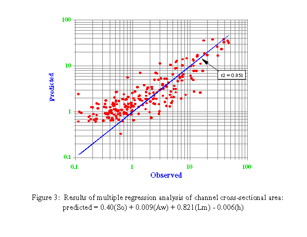
Several GIS-derived watershed variables, notably watershed area and the maximum flow length within a watershed were shown to be important factors for predicting channel shape (Table 2). Maximum flow length is defined as the length of the flow path from the farthest reaches of the watershed in question to its outlet. Cumulative channel length was found by summing the lengths of all channels within the subwatershed. The strong correlations among variables is not surprising, since watershed area is strongly linked to total runoff and channel shape, and the flow length within a watershed is an indicator of flow energy and power during a storm, especially when correlated with relief (Leopold and Maddock, 1953; Osterkamp and Hedman, 1977; Dunkerly, 1992). Multiple regression analysis shows that cross-sectional area was strongly related to many watershed characteristics (Table 3; Figure 3). Because the relationships between channel shape and watershed variables are strong, they can be used to attribute a GIS database for use in hydrologic modeling where little to no field research has been conducted. Digital elevation models and terrain analysis packages allow for the gross characterization of surface morphology, but are limited in application for smaller features such as channel morphology. With verification, these relationships may be applied on other watersheds in the Southwest, thereby reducing the dependency on time-intensive and costly field surveys.
Table 2: Results of simple linear regression analysis between channel shape and watershed variables.
| Dependent | Independent | r^2 | coefficient | constant | SEyx |
| log depth | log watershed area | 0.33 | 0.15 | 0.70 | 0.22 |
| log depth | log max flowlength | 0.33 | 0.11 | 0.75 | 0.22 |
| log width | log watershed area | 0.72 | 0.34 | 0.86 | 0.21 |
| width | max flowlength | 0.78 | 0.14 | 339.27 | 452.88 |
| log cross-sectional area | log watershed area | 0.68 | 0.49 | -2.44 | 0.34 |
| cross-sectional area | max flowlength | 0.79 | 0.001 | 1.83 | 3.46 |
| case | regression model | r^2 | SEyx |
| 1 | 0.686(So) + 0.065(Aw) + 0.909(Lm) - 0.006(h) | 0.849 | 3.36 |
| 2 | 0.40(So) + 0.009(Ap) + 0.821(Lm) - 0.006(h) | 0.851 | 3.35 |
| 3 | 0.72(So) + 0.095(Aw) +0.001(Lm) - 0.007(h) - 0.001(Dl) | 0.851 | 3.34 |
| 4 | 0.616(So) + 0.001(Lm) + 0.001(S) | 0.849 | 3.42 |
where: So = stream order; Aw = subwatershed area (m^2); Ap = area:perimeter ratio (m); Lm = maximum flow length (m); h = relief (m); Dl = sum of drainage lengths (m); S = basin slope (deg); r^2 = coefficient of determination; and, SEyx = standard error of Y estimate
A primary goal of this project was to create a high-resolution, highly accurate representation of Walnut Gulch within a GIS environment. On an area such as Walnut Gulch, where watershed processes are investigated at different scales and an abundant amount of research is performed, a GIS can be a valuable asset. Small changes in spatial data can be measured and stored within the GIS, which should aid in the development and refinement of large-scale models sensitive to minor perturbations in their parameters.
GIS analysis affords the researcher an enormous improvement in the time necessary to analyze spatially distributed data. The protocol and programs developed during this research allowed for the analysis of over two hundred watersheds. These analyses each represented an enormous amount of computational work, far beyond the ability of a person to do either by hand, using conventional programming or spreadsheets given the amount of time required to complete this project.
A more thorough understanding of the hydrologic principles and geomorphologic interrelationships of Walnut Gulch was the final objective of this project. It has been said that there are perhaps only three truly independent variables; climate, geology, and time and that all else can be derived from the interaction between them (Osterkamp, 1995). However, for the purposes of geomorphologic investigation, it is necessary to utilize variables that are more easily obtained and quantified. Strong relationships were developed among channel shape characteristics and watershed parameters. Channel cross-sectional area appears to be a function of several basic watershed variables that govern the hydrologic response and therefore the shape of channels within Walnut Gulch. It is recognized that field research is the most appropriate method to obtain accurate measurements of parameters necessary for the parameterization of hydrologic models. Where field work is unavailable or limited, however, substitute parameters must be used in the place of measured values. In the southwestern United States, the hydrologic relationships that were derived using both field-based and GIS analysis tools may be implemented within hydrologic models, thereby reducing the time and costs associated with parameterizing these models.
(1) Names are necessary to report factually on available data; however, the USDA neither guarantees nor warrants the standard of the product, and the use of the name by USDA implies no approval of the product to the exclusion of others that may also be suitable.
Alley, W. M., and P. E. Smith, 1982. Distributed routing rainfall-runoff model - version II. Computer program documentation user's manual. USGS-WRD open-file report 82-344. Gulf Coast Hydroscience Center, NSTL Station, Mississippi.
Anderson, H. W., 1957. Relating sediment yield to watershed variables. Transactions of the American Geophysical Union 45: 307-321.
Breckenfield, D. J., W. A. Svetlik, and C. E. McGuire, 1995. Soil Survey of Walnut Gulch Experimental Watershed. United States Department of Agriculture, Soil Conservation Service.
Burrough, P. A., 1986. Principles of Geographical Information Systems for Land Use . Oxford University Press. New York. 194 pp.
Dunkerly, D. L., 1992. Channel geometry, bed material, and inferred flow conditions in ephemeral stream systems, Barrier Range, western N.S.W. Australia. Hydrological Processes 6:417-433.
Environmental Systems Research Institute (Esri), 1994. ArcInfo ver. 7.0 manual (on-line documentation), Environmental Systems Research Institute, Corp. Redlands, CA.
Feldman, A. D., 1995. HEC-1 flood hydrograph package. Chapter 4 of Computer Models of Watershed Hydrology. Water Resources Pub. Highlands Ranch, CO. pp. 119-150.
Gordon, N. D., T. A. McMahon, and B. L. Finlayson, 1992. Stream Hydrology an Introduction for Ecologists. John Wiley and Sons. New York. 526 pp.
Harrelson, C. C., C. L. Rawlins, and J. P. Potyondy, 1994. Stream channel reference sites: an illustrated guide to field technique. USDA Forest Service General Technical Report RM-245. 61 pp.
Lanfear, K. J., 1990. A fast algorithm for automatically computing Strahler stream order. Water Resources Bulletin 26(6):977-981.
Leopold, L. B., and T. Maddock, Jr., 1953. The hydraulic geometry of stream channels and some physiographic implications. U.S. Geological Survey Professional Paper 252.
Leopold, L. B., M. G. Wolman, and J. P. Miller, 1964. Fluvial Processes in Geomorphology. W. H. Freeman & Co. San Francisco. 522 pp.
Libby, F. J., D. E. Wallace, and D. P. Spangler, 1970. Seismic refraction studies of the subsurface geology of the Walnut Gulch Experimental Watershed, AZ. USDA-ARS 41-164. 14 pp.
Osterkamp, W. R., and E.R. Hedman, 1977. Variation of width and discharge for natural high-gradient stream channels. Water Resources Research 13(2):256-258.
Osterkamp, W. R., L.J. Lane, and G.R. Foster, 1983. An analytical treatment of channel-morphology relations. U.S. Geological Survey Professional Paper 1288. 21 pp.
Renard, K. G., L. J. Lane, J. R. Simanton, W. E. Emmerich, J. J. Stone, M. A. Weltz, D. C. Goodrich, and D. S. Yakowitz, 1993. Agricultural impacts in an arid environment: Walnut Gulch studies. Hydrologic Science and Technology 9(1-4): 145-190.
Strahler, A. N., 1964. Quantitative geomorphology of drainage basins and channel networks. in: Handbook of Applied Hydrology, Ven Te Chow editor. McGraw Hill, New York. pp. 4-39 - 4-76.
Woolhiser, D. A., R. E. Smith, and D. C. Goodrich, 1990. KINEROS - A kinematic runoff and erosion model; documentation and user manual. USDA-ARS Pub. ARS-77. 130 pp.
D. Phillip Guertin
University of Arizona
Advanced Resource Technology Group
325 Biological Sciences East
Tucson, Arizona 85721
tel: 520-621-1723
fax: 520-621-8801
phil@nexus.srnr.arizona.edu
David C. Goodrich
USDA ARS - Southwest Watershed Research Center
2000 E. Allen Rd.
Tucson, Arizona 85719
tel: 520-670-6380 ext. 162
fax: 520-670-5550
goodrich@tucson.ars.ag.gov