Connecting Students with Community Partners
Additional partners; the city GIS director, State of North Carolina
Archivists, the director of Raleigh City Planning, and faculty from the
NCSU School of Forestry Wood and Paper Products Lab were consulted and
visited. Professors and graduate students spent hours in field research
gathering information for the middle school teachers and students to use
in their projects.
Field trips for middle school students were funded through grants and
coordinated by the teachers and professors. These trips were informative,
educational, and motivational. The actual field experiences made the virtual
information come alive. Before the field trips, the project was abstract
to the students, another academic exercise. Afterwards they could visualize
what life was like in the 1953 Ė 1971 time period and how this history
would be recorded. Students were motivated to continue their research and
be persistent.
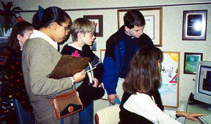 |
The GIS students explored the history of Raleigh through GIS at the
Raleigh GIS office, maps at the State of NC Archives, and a tour
of the historic sections of the city. We first visited the Raleigh GIS
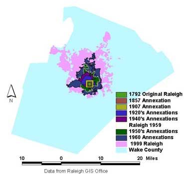
office. Colleen Sharpe, director, showed us the city annexation map. It
illustrated the growth of the city. Students immediately saw how we could
use GIS to show change over time from the late 1700ís to the present. |
| An annexation map of Raleigh helped both students and teachers visualize
how GIS can be used to show change over time. |
 |
| Employees shared several of the current GIS projects for the City of
Raleigh. Students were impressed to learn that legislators frequently requested
GIS models before making decisions. Students looked at the GIS databases
of land parcels. Finding their homes in the database complete with pictures
particularly amazed them. They also noted issues of privacy associated
with such information. The Raleigh GIS office supplied us with databases
for annexation, county streets, public schools, land parcels, and census
tracts. |
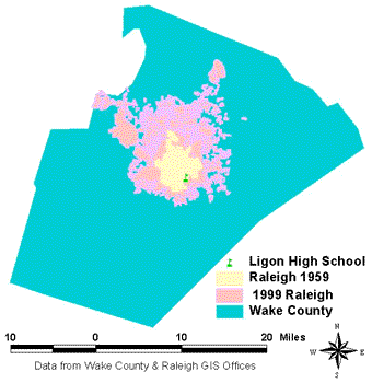 |
LHS was the only high school for Blacks in the Raleigh City School
System. In 1971, under orders to desegregate, the city and county school
systems consolidated. Black students were then bused out of their neighborhoods
to high schools all over the county. Using GIS we can effectively illustrate
the Diaspora from a geographic perspective. Wake County is shown in blue,
the city of Raleigh in 1950 in yellow, and the current city limits in pink. |
|
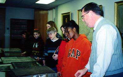 |
Our next stop was the State of North Carolina Archives. Ed Morris displayed
maps of Raleigh and Wake County sequentially from the original William
Christmas plan for the city to a current map of Raleigh. Students were
most impressed with a "Birdís Eye View" map drawn of Raleigh from a hot
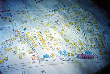
air balloon in the 1800ís and the historic Sanborn maps. They were appalled
that changes were made to the maps by pasting over original information.
Mr. Morris provided us with copies of maps from many time periods. Some
of these maps were later digitized to form the basis for the a student's
Railroad Development GIS project and another studentís Raleigh Trolley
Tour GIS project and web site. The maps were used extensively by the Wake
County Heritage class in their study of architectural history of the area. |
| The historic Sanborn maps illustrated areas of Raleigh designated "colored"
or "Negro." The maps were shocking and revelatory for many of the project
participants, but familiar territory for the Alumni whose daily lives had
been lived in its separate spaces. Seeing these maps led us to understand
the GIS project in different terms. We began to understand that the history
of the segregated period from an African American perspective was frequently
not recorded as "official" history, and that representing the information
about the Alumni's lives in GIS formats would challenge the boundaries
of official layers of GIS information. |
|
|
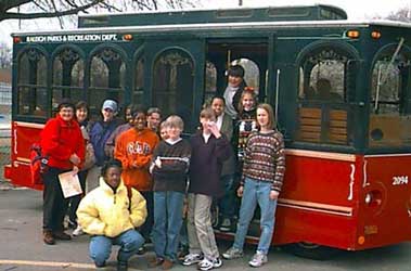 |
The GIS class completed their day, exploring historic areas of the
city on the Great Raleigh Trolley tour. Dr. Candy Beal, author of Raleigh:
the First 200 Years (1992), narrated the tour that included buildings
of historical significance in the downtown area. Several sites had significance
for the Ligon History project including the home and business owned by
J. W. Ligon, Chavis Park, Saint Augustineís College, St. Agnes Hospital,
the downtown shopping districts, Mooreís Square (known in the 50ís as Baptist
Grove), Washington School, and Shaw University. Students took pictures
during this tour that were added as hotlinks to the GIS model of Mr. Hunter's
Mental Map of the 1950ís. Josh Carter, a student in both the GIS class
and the Electronic Publishing class, has made a web site of the tour and
will make a GIS model of the tour with hotlinks to all the web pages. |
|
Students in the GIS class had an excellent experience on this field
trip. The sequence of the visits helped them visualize complex mapping
concepts and made the history come alive. They saw GIS models of the city
and its growth, then the hand drawn maps that showed the same development.
On the trolley trip they saw the buildings and experienced their locations.
This day motivated students to gather data and find ways to communicate
the history.
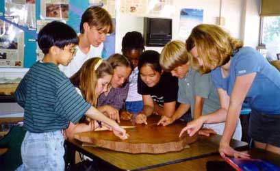 |
Inspired by "tree cookies" saved from mature willow oaks cut from the
property during renovation, Virginia Owens introduced her sixth grade science
students to the study of dendrochronology. Owens consulted scientists at
the NCSU College of Forestry Wood and Paper Products lab to prepare for
this study. Unfortunately the lab was not a safe place for students to
visit, so Owens and Hagevik visited the lab and photographed the scientists
as they processed the tree cookies. They also consulted specialists at
US Division of Forest Resources, the US Forest Service, and the Forest
History Society. Guest speakers spoke to the students and helped them do
field research on trees on the campus. Because of this support student
dendrochronologists learned complex scientific information and were able
to determine the age of the tree. For an overview of this aspect of the
project visit "Ligon's
History in the Rings." |
Return to Exploring the Past to Influence the
Future
Background Information about the School | School
Connecting to the Alumni | School Connecting with
the Community
Background on the Collaboration | Community
Connecting with the School
Role of GIS in the Project | Sharing
the Project Products | How did students benefit
from the project?
...To Guide the Future
